Honnedaga Lake Topo Map New York
To zoom in, hover over the map of Honnedaga Lake
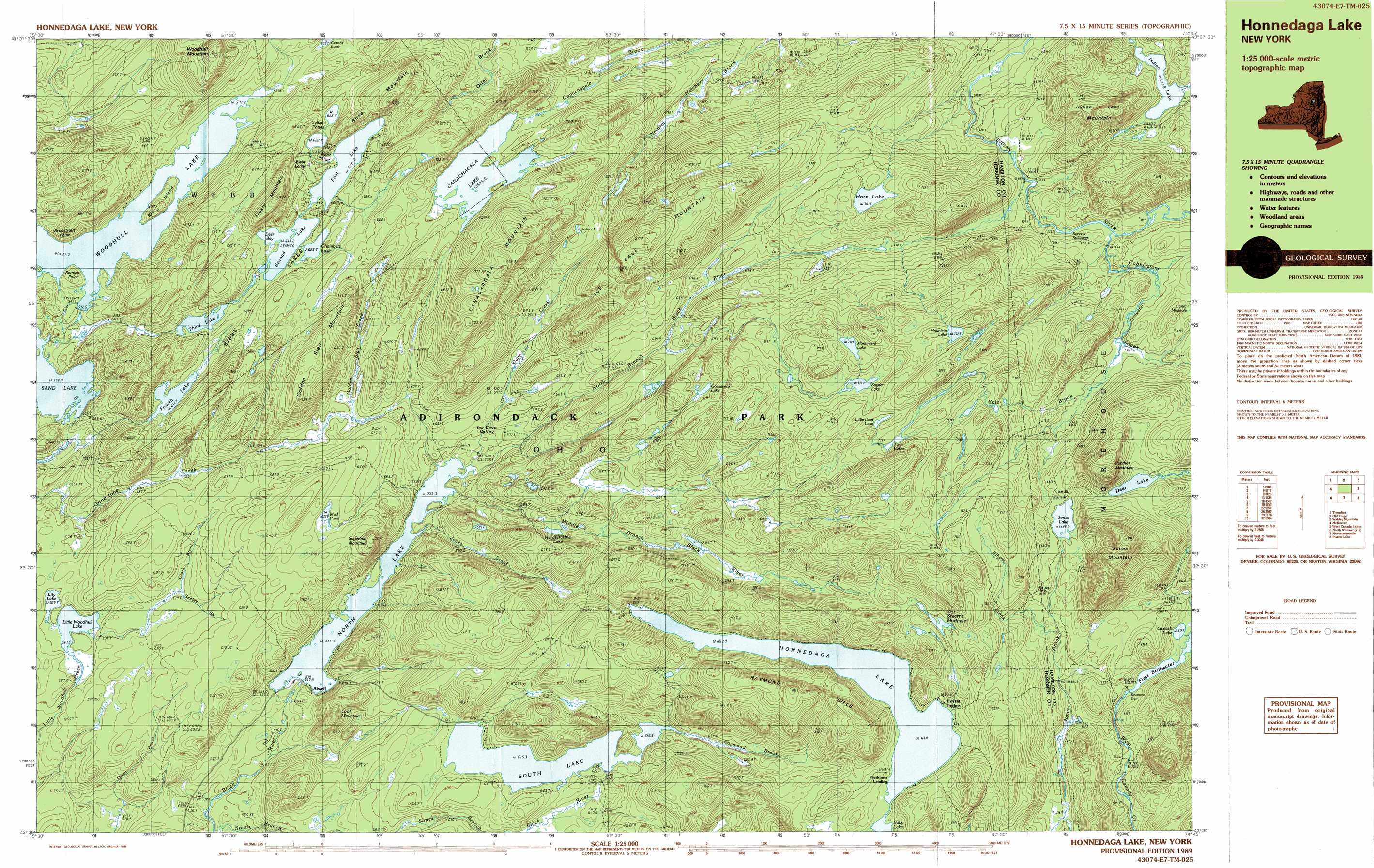
USGS Topo Quad 43074e7 - 1:25,000 scale
| Topo Map Name: | Honnedaga Lake |
| USGS Topo Quad ID: | 43074e7 |
| Print Size: | ca. 39" wide x 24" high |
| Southeast Coordinates: | 43.5° N latitude / 74.75° W longitude |
| Map Center Coordinates: | 43.5625° N latitude / 74.875° W longitude |
| U.S. State: | NY |
| Filename: | k43074e7.jpg |
| Download Map JPG Image: | Honnedaga Lake topo map 1:25,000 scale |
| Map Type: | Topographic |
| Topo Series: | 7.5´x15´ |
| Map Scale: | 1:25,000 |
| Source of Map Images: | United States Geological Survey (USGS) |
| Alternate Map Versions: |
Honnedaga Lake NY 1989, updated 1989 Download PDF Buy paper map Honnedaga Lake NY 1989, updated 1989 Download PDF Buy paper map |
1:24,000 Topo Quads surrounding Honnedaga Lake
Stillwater Mountain |
Eagle Bay |
Sargent Ponds |
||
Thendara |
Limekiln Lake |
Wakely Mountain |
||
Otter Lake |
Honnedaga Lake |
Spruce Lake |
||
North Wilmurt |
Morehouseville |
Piseco Lake |
||
Hinckley |
Jerseyfield Lake |
Tomany Mountain |
> Back to 43074e1 at 1:100,000 scale
> Back to 43074a1 at 1:250,000 scale
> Back to U.S. Topo Maps home
Honnedaga Lake topo map: Gazetteer
Honnedaga Lake: Bays
Deer Bay elevation 618m 2027′Honnedaga Lake: Benches
Bisby Lodge elevation 627m 2057′Honnedaga Lake: Capes
Brooktrout Point elevation 576m 1889′Remson Point elevation 582m 1909′
Honnedaga Lake: Dams
Swanson Dam elevation 636m 2086′Honnedaga Lake: Islands
Big Island elevation 608m 1994′Honnedaga Lake: Lakes
Baby Lake elevation 667m 2188′Bisby Lakes elevation 617m 2024′
Canachagala Lake elevation 656m 2152′
Caswell Lake elevation 632m 2073′
Chamber Lake elevation 625m 2050′
Combs Lake elevation 575m 1886′
Deer Lake elevation 724m 2375′
First Lake elevation 618m 2027′
Fourth Lake elevation 610m 2001′
Gooseneck Lake elevation 714m 2342′
Hardscrabble Lake elevation 627m 2057′
Honnedaga Lake elevation 667m 2188′
Horn Lake elevation 701m 2299′
Indian Lake elevation 654m 2145′
Jones Lake elevation 688m 2257′
Lily Lake elevation 569m 1866′
Little Deer Lake elevation 749m 2457′
Little Woodhull Lake elevation 567m 1860′
Monument Lake elevation 758m 2486′
Mountain Lake elevation 772m 2532′
Mud Pond elevation 633m 2076′
North Lake elevation 555m 1820′
Sand Lake elevation 556m 1824′
Second Lake elevation 618m 2027′
Second Stillwater elevation 630m 2066′
Snyder Lake elevation 733m 2404′
Stearns Mudhole elevation 717m 2352′
Sylvan Ponds elevation 625m 2050′
Third Lake elevation 615m 2017′
Twin Lakes elevation 737m 2417′
Woodhull Lake elevation 571m 1873′
Honnedaga Lake: Populated Places
Atwell elevation 556m 1824′Herkimer Landing elevation 668m 2191′
Honnedaga Lake: Reservoirs
First Stillwater elevation 632m 2073′South Lake elevation 615m 2017′
Honnedaga Lake: Streams
Clark Brook elevation 570m 1870′Cobblestone Creek elevation 630m 2066′
Elbow Brook elevation 666m 2185′
Golden Stair Creek elevation 557m 1827′
Hoxie Brook elevation 581m 1906′
Ice Cave Creek elevation 555m 1820′
Jocks Brook elevation 555m 1820′
Little Salmon Outlet elevation 602m 1975′
Middle Branch Black River elevation 556m 1824′
Muskrat Creek elevation 654m 2145′
Nelson Brook elevation 581m 1906′
North Branch Black River elevation 564m 1850′
Raymond Brook elevation 616m 2020′
Seeley Brook elevation 587m 1925′
South Branch Black River elevation 529m 1735′
Yale Brook elevation 660m 2165′
Honnedaga Lake: Summits
Canachagala Mountain elevation 791m 2595′Cool Mountain elevation 687m 2253′
Golden Stair Mountain elevation 733m 2404′
Ice Cave Mountain elevation 817m 2680′
Indian Lake Mountain elevation 795m 2608′
Jones Mountain elevation 880m 2887′
Panther Mountain elevation 850m 2788′
Raymond Hills elevation 793m 2601′
Rose Mountain elevation 709m 2326′
Sugarloaf Mountain elevation 694m 2276′
Trusty Mountain elevation 720m 2362′
Woodhull Mountain elevation 719m 2358′
Honnedaga Lake: Valleys
Ice Cave Valley elevation 563m 1847′Honnedaga Lake digital topo map on disk
Buy this Honnedaga Lake topo map showing relief, roads, GPS coordinates and other geographical features, as a high-resolution digital map file on DVD:
New York, Vermont, Connecticut & Western Massachusetts
Buy digital topo maps: New York, Vermont, Connecticut & Western Massachusetts