Starbuck Mountain Topo Map New York
To zoom in, hover over the map of Starbuck Mountain
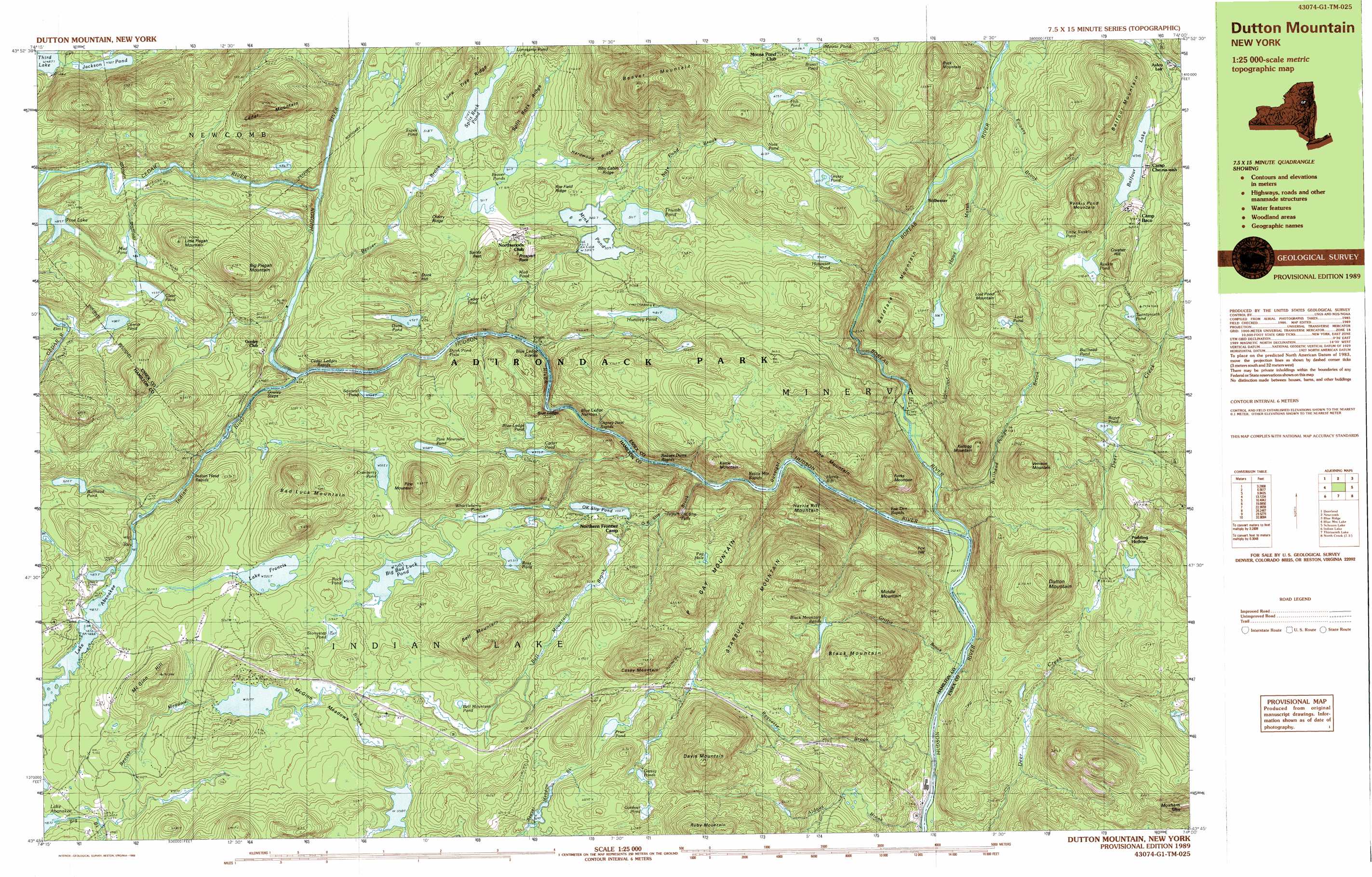
USGS Topo Quad 43074g1 - 1:25,000 scale
| Topo Map Name: | Starbuck Mountain |
| USGS Topo Quad ID: | 43074g1 |
| Print Size: | ca. 39" wide x 24" high |
| Southeast Coordinates: | 43.75° N latitude / 74° W longitude |
| Map Center Coordinates: | 43.8125° N latitude / 74.125° W longitude |
| U.S. State: | NY |
| Filename: | k43074g1.jpg |
| Download Map JPG Image: | Starbuck Mountain topo map 1:25,000 scale |
| Map Type: | Topographic |
| Topo Series: | 7.5´x15´ |
| Map Scale: | 1:25,000 |
| Source of Map Images: | United States Geological Survey (USGS) |
| Alternate Map Versions: |
Dutton Mountain NY 1989, updated 1989 Download PDF Buy paper map Dutton Mountain NY 1997, updated 2000 Download PDF Buy paper map |
1:24,000 Topo Quads surrounding Starbuck Mountain
Kempshall Mountain |
Mount Adams |
Dix Mountain |
||
Dunbrook Mountain |
Vanderwhacker Mountain |
Blue Ridge |
||
Burgess Mountain |
Starbuck Mountain |
Schroon Lake |
||
Sabael |
Gore Mountain |
North Creek |
Chestertown |
|
Kunjamuk River |
Bakers Mills |
Johnsburg |
The Glen |
> Back to 43074e1 at 1:100,000 scale
> Back to 43074a1 at 1:250,000 scale
> Back to U.S. Topo Maps home
Starbuck Mountain topo map: Gazetteer
Starbuck Mountain: Benches
Blue Ledge elevation 494m 1620′Starbuck Mountain: Islands
Elm Island elevation 476m 1561′Starbuck Mountain: Lakes
Balfour Lake elevation 545m 1788′Beaver Ponds elevation 514m 1686′
Bell Mountain Pond elevation 545m 1788′
Big Bad Luck Pond elevation 515m 1689′
Bissell Pond elevation 640m 2099′
Black Mountain Ponds elevation 603m 1978′
Blue Ledge Pond elevation 487m 1597′
Bullhead Pond elevation 500m 1640′
Bullhead Pond elevation 570m 1870′
Carter Pond elevation 475m 1558′
Cedar Pond elevation 501m 1643′
Clear Pond elevation 493m 1617′
Corner Pond elevation 490m 1607′
Cranberry Pond elevation 515m 1689′
Dunk Pond elevation 472m 1548′
Fish Pond elevation 655m 2148′
Frank Pond elevation 518m 1699′
Gardner Pond elevation 581m 1906′
Grassy Pond elevation 621m 2037′
Grassy Ponds elevation 575m 1886′
Hotwater Pond elevation 540m 1771′
Huntley Pond elevation 481m 1578′
Jackson Pond elevation 490m 1607′
Lake Francis elevation 505m 1656′
Little Rankin Pond elevation 603m 1978′
Lonesome Pond elevation 519m 1702′
Lost Pond elevation 585m 1919′
Mink Pond elevation 510m 1673′
Mud Pond elevation 483m 1584′
Mud Pond elevation 486m 1594′
Nate Pond elevation 613m 2011′
O K Slip Pond elevation 492m 1614′
Pine Lake elevation 485m 1591′
Pine Mountain Pond elevation 502m 1646′
Prier Pond elevation 568m 1863′
Pug Hole elevation 580m 1902′
Rankin Pond elevation 578m 1896′
Rock Pond elevation 520m 1706′
Roper Pond elevation 515m 1689′
Ross Pond elevation 531m 1742′
Split Rock Pond elevation 514m 1686′
Squirrel Pond elevation 466m 1528′
Stonystep Pond elevation 520m 1706′
Thumb Pond elevation 511m 1676′
Twentyninth Pond elevation 615m 2017′
Whortleberry Pond elevation 506m 1660′
Starbuck Mountain: Pillars
Prospect Rock elevation 569m 1866′Starbuck Mountain: Populated Places
Aiden Lair elevation 497m 1630′Northwoods Club elevation 539m 1768′
Pudding Hollow elevation 533m 1748′
Stillwater elevation 458m 1502′
Starbuck Mountain: Reservoirs
Lake Abanakee elevation 488m 1601′Starbuck Mountain: Ridges
Biby Cabin Ridge elevation 552m 1811′Cherry Ridge elevation 561m 1840′
Hardwood Ridge elevation 579m 1899′
Lone Tree Ridge elevation 601m 1971′
Rye Field Ridge elevation 545m 1788′
Split Rock Ridge elevation 615m 2017′
Starbuck Mountain: Streams
Aldous Brook elevation 332m 1089′Beaver Brook elevation 438m 1437′
Beaver Meadow Brook elevation 491m 1610′
Bell Mountain Brook elevation 491m 1610′
Boreas River elevation 354m 1161′
Bullhead Pond Brook elevation 355m 1164′
Cedar River elevation 444m 1456′
Griffin Brook elevation 339m 1112′
Indian River elevation 427m 1400′
Nate Pond Brook elevation 428m 1404′
O K Slip Brook elevation 383m 1256′
Powers Brook elevation 459m 1505′
Raquette Brook elevation 341m 1118′
Starbuck Mountain: Summits
Bad Luck Mountain elevation 653m 2142′Baldface Mountain elevation 626m 2053′
Balfour Mountain elevation 727m 2385′
Beaver Mountain elevation 882m 2893′
Bell Mountain elevation 713m 2339′
Big Pisgah Mountain elevation 622m 2040′
Black Mountain elevation 698m 2290′
Buck Mountain elevation 667m 2188′
Casey Mountain elevation 745m 2444′
Cedar Mountain elevation 752m 2467′
Crusher Hill elevation 672m 2204′
Davis Mountain elevation 780m 2559′
Dunk Hill elevation 612m 2007′
Dutton Mountain elevation 702m 2303′
Forks Mountain elevation 591m 1938′
Fox Hill elevation 552m 1811′
Harris Rift Mountain elevation 549m 1801′
Kellogg Mountain elevation 639m 2096′
Kettle Mountain elevation 580m 1902′
Little Pisgah Mountain elevation 614m 2014′
Lost Pond Mountain elevation 660m 2165′
McGinn Hill elevation 620m 2034′
Middle Mountain elevation 674m 2211′
P Gay Mountain elevation 713m 2339′
Pine Mountain elevation 636m 2086′
Pine Mountain elevation 626m 2053′
Rankin Pond Mountain elevation 692m 2270′
Saints Rest elevation 580m 1902′
Starbuck Mountain elevation 772m 2532′
Venison Mountain elevation 702m 2303′
Starbuck Mountain: Swamps
Howe Marsh elevation 456m 1496′McGinn Meadows elevation 528m 1732′
Starbuck Mountain digital topo map on disk
Buy this Starbuck Mountain topo map showing relief, roads, GPS coordinates and other geographical features, as a high-resolution digital map file on DVD:
New York, Vermont, Connecticut & Western Massachusetts
Buy digital topo maps: New York, Vermont, Connecticut & Western Massachusetts