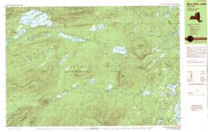
Burgess Mountain Topo Map New York
To zoom in, hover over the map of Burgess Mountain
USGS Topo Quad 43074g3 - 1:25,000 scale
| Topo Map Name: | Burgess Mountain |
| USGS Topo Quad ID: | 43074g3 |
| Print Size: | ca. 39" wide x 24" high |
| Southeast Coordinates: | 43.75° N latitude / 74.25° W longitude |
| Map Center Coordinates: | 43.8125° N latitude / 74.375° W longitude |
| U.S. State: | NY |
| Filename: | k43074g3.jpg |
| Download Map JPG Image: | Burgess Mountain topo map 1:25,000 scale |
| Map Type: | Topographic |
| Topo Series: | 7.5´x15´ |
| Map Scale: | 1:25,000 |
| Source of Map Images: | United States Geological Survey (USGS) |
| Alternate Map Versions: |
Blue Mtn Lake NY 1989, updated 1989 Download PDF Buy paper map Blue Mtn Lake NY 1997, updated 1999 Download PDF Buy paper map |
1:24,000 Topo Quads surrounding Burgess Mountain
> Back to 43074e1 at 1:100,000 scale
> Back to 43074a1 at 1:250,000 scale
> Back to U.S. Topo Maps home
Burgess Mountain topo map: Gazetteer
Burgess Mountain: Airports
Eagle Nest Seaplane Base elevation 577m 1893′Burgess Mountain: Capes
Bluff Point elevation 548m 1797′Mallard Point elevation 512m 1679′
Popple Point elevation 546m 1791′
Burgess Mountain: Islands
Long Island elevation 556m 1824′Osprey Island elevation 551m 1807′
Burgess Mountain: Lakes
Barker Pond elevation 565m 1853′Blue Mountain Lake elevation 546m 1791′
Brady Pond elevation 682m 2237′
Cascade Pond elevation 652m 2139′
Crystal Lake elevation 573m 1879′
Dishrag Pond elevation 760m 2493′
Eagle Lake elevation 546m 1791′
First Lake elevation 486m 1594′
Grassy Pond elevation 567m 1860′
Grassy Pond elevation 495m 1624′
Lake Durant elevation 540m 1771′
Little Grassy Pond elevation 501m 1643′
Long Pond elevation 586m 1922′
Mitchell Ponds elevation 653m 2142′
Potter Pond elevation 634m 2080′
Rock Lake elevation 521m 1709′
Rock Pond elevation 540m 1771′
Second Lake elevation 488m 1601′
Slim Pond elevation 655m 2148′
Sprague Pond elevation 563m 1847′
Stephens Pond elevation 596m 1955′
Unknown Pond elevation 494m 1620′
Wilson Pond elevation 658m 2158′
Burgess Mountain: Parks
Byron Park elevation 507m 1663′Burgess Mountain: Populated Places
Blue Mountain Lake elevation 556m 1824′Eagle Nest elevation 574m 1883′
Indian Lake elevation 531m 1742′
Burgess Mountain: Reservoirs
Adirondack Lake elevation 506m 1660′Indian Lake elevation 503m 1650′
Burgess Mountain: Ridges
Blue Ridge elevation 972m 3188′White Birch Ridge elevation 549m 1801′
Burgess Mountain: Streams
Bear Trap Brook elevation 507m 1663′Beaver Brook elevation 551m 1807′
Big Brook elevation 487m 1597′
Browns Brook elevation 558m 1830′
Dun Brook elevation 486m 1594′
Johnny Mack Brook elevation 522m 1712′
Nicholas Brook elevation 505m 1656′
Rock River elevation 470m 1541′
Round Pond Brook elevation 487m 1597′
Sprague Brook elevation 546m 1791′
Burgess Mountain: Summits
Blue Mountain elevation 1143m 3750′Burgess Mountain elevation 973m 3192′
Crow Hill elevation 595m 1952′
Ledger Mountain elevation 662m 2171′
Little Mill Mountain elevation 603m 1978′
Metcalf Mountain elevation 1007m 3303′
Mill Mountain elevation 661m 2168′
Round Top elevation 844m 2769′
Sawyer Mountain elevation 788m 2585′
Stark Hills elevation 696m 2283′
Sugarloaf Mountain elevation 849m 2785′
Burgess Mountain: Swamps
Bear Trap Swamp elevation 544m 1784′O'Neil Flow elevation 550m 1804′
Burgess Mountain: Trails
Northville Lake Placid Trail elevation 550m 1804′Burgess Mountain digital topo map on disk
Buy this Burgess Mountain topo map showing relief, roads, GPS coordinates and other geographical features, as a high-resolution digital map file on DVD:
New York, Vermont, Connecticut & Western Massachusetts
Buy digital topo maps: New York, Vermont, Connecticut & Western Massachusetts


