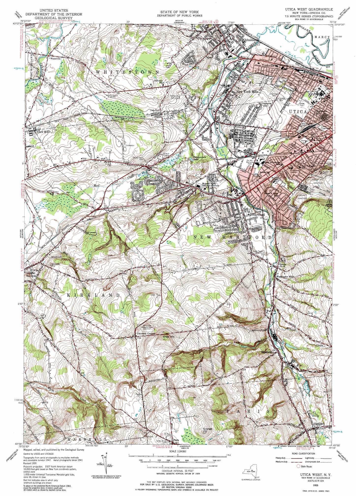
Utica West Topo Map New York
To zoom in, hover over the map of Utica West
USGS Topo Quad 43075a3 - 1:24,000 scale
| Topo Map Name: | Utica West |
| USGS Topo Quad ID: | 43075a3 |
| Print Size: | ca. 21 1/4" wide x 27" high |
| Southeast Coordinates: | 43° N latitude / 75.25° W longitude |
| Map Center Coordinates: | 43.0625° N latitude / 75.3125° W longitude |
| U.S. State: | NY |
| Filename: | o43075a3.jpg |
| Download Map JPG Image: | Utica West topo map 1:24,000 scale |
| Map Type: | Topographic |
| Topo Series: | 7.5´ |
| Map Scale: | 1:24,000 |
| Source of Map Images: | United States Geological Survey (USGS) |
| Alternate Map Versions: |
Utica West NY 1949 Download PDF Buy paper map Utica West NY 1955, updated 1957 Download PDF Buy paper map Utica West NY 1955, updated 1989 Download PDF Buy paper map Utica West NY 2010 Download PDF Buy paper map Utica West NY 2013 Download PDF Buy paper map Utica West NY 2016 Download PDF Buy paper map |
1:24,000 Topo Quads surrounding Utica West
Lee Center |
Westernville |
North Western |
Remsen |
Hinckley |
Verona |
Rome |
Oriskany |
South Trenton |
Newport |
Vernon |
Clinton |
Utica West |
Utica East |
Ilion |
Munnsville |
Oriskany Falls |
Cassville |
West Winfield |
Millers Mills |
Hamilton |
Hubbardsville |
Brookfield |
Unadilla Forks |
Schuyler Lake |
> Back to 43075a1 at 1:100,000 scale
> Back to 43074a1 at 1:250,000 scale
> Back to U.S. Topo Maps home
Utica West topo map: Gazetteer
Utica West: Airports
Saint Elizabeth Hospital Heliport elevation 174m 570′Saint Lukes Memorial Hospital Heliport elevation 174m 570′
Utica West: Channels
Highland Congregation of Jehovahs Witnesses elevation 143m 469′Utica West: Lakes
Yahnundasis Lake elevation 150m 492′Utica West: Parks
Addison Miller Park elevation 155m 508′Charles A Gaetano Stadium elevation 163m 534′
Dix Mix Memorial Field elevation 157m 515′
Duffy Plaza elevation 169m 554′
Horatio Seymour Park elevation 156m 511′
Lincoln Playground elevation 145m 475′
Pixley Park elevation 156m 511′
Pulaski Park elevation 138m 452′
Romano Plaza elevation 170m 557′
Utica West: Populated Places
Applewood Community elevation 180m 590′Brookside Manor elevation 208m 682′
Chadwicks elevation 216m 708′
Chuckery Corners elevation 324m 1062′
Millgate Meadows elevation 164m 538′
New Hartford elevation 165m 541′
New York Mills elevation 142m 465′
Paris elevation 454m 1489′
Sauquoit elevation 264m 866′
Sauquoit Mobile Home Park elevation 256m 839′
Walesville elevation 144m 472′
Washington Mills elevation 189m 620′
Whitesboro elevation 129m 423′
Yorkville elevation 132m 433′
Utica West: Streams
Deans Creek elevation 140m 459′Mud Creek elevation 131m 429′
Nail Creek elevation 164m 538′
Roberts Creek elevation 200m 656′
Sauquoit Creek elevation 120m 393′
Sherman Brook elevation 166m 544′
Utica West: Summits
Burrstone Hill elevation 183m 600′Crow Hill elevation 399m 1309′
Grange Hill elevation 473m 1551′
Harts Hill elevation 210m 688′
The Knob elevation 208m 682′
Utica West: Valleys
The Glen elevation 212m 695′Utica West digital topo map on disk
Buy this Utica West topo map showing relief, roads, GPS coordinates and other geographical features, as a high-resolution digital map file on DVD:
New York, Vermont, Connecticut & Western Massachusetts
Buy digital topo maps: New York, Vermont, Connecticut & Western Massachusetts