Verona Topo Map New York
To zoom in, hover over the map of Verona
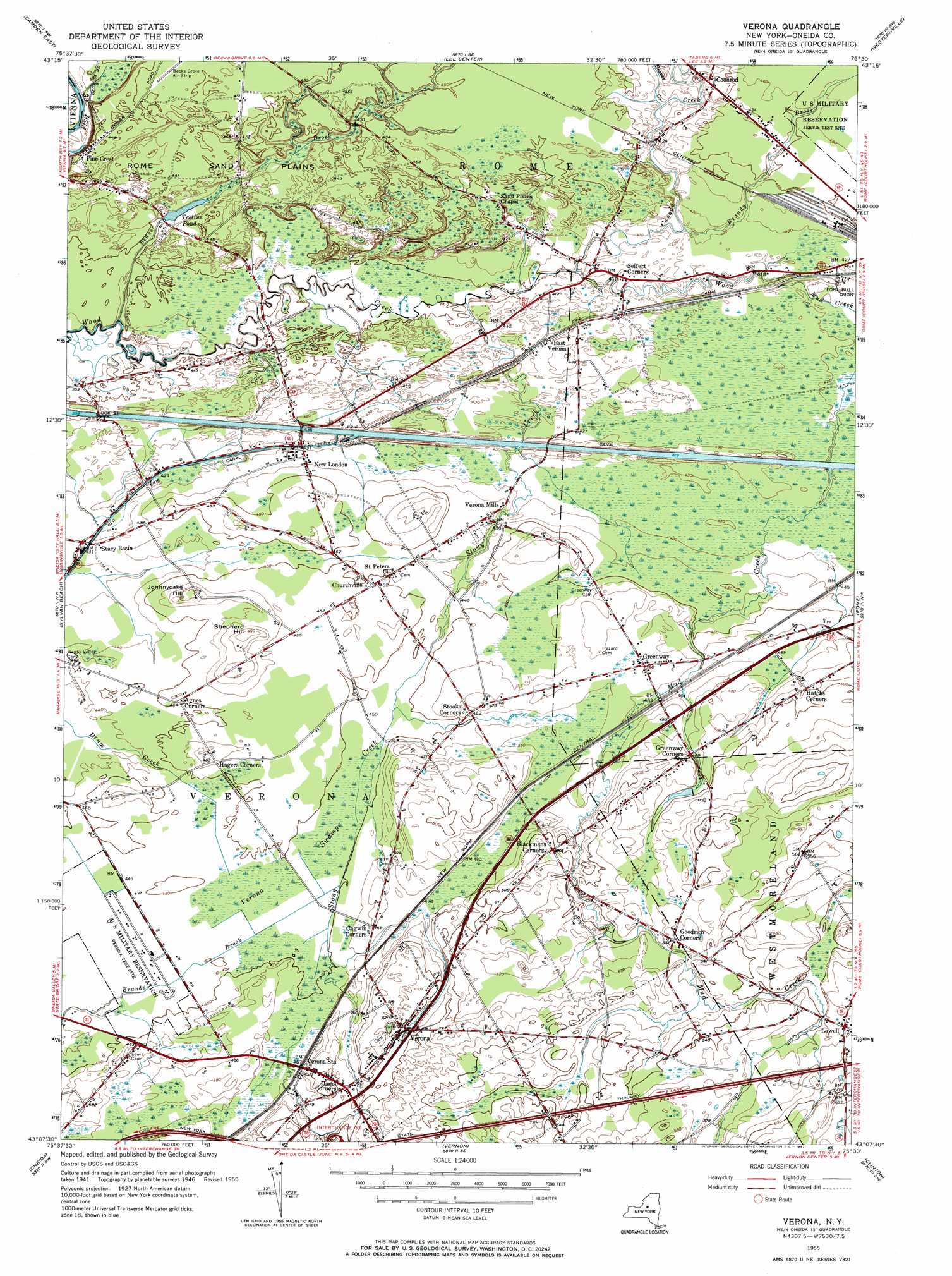
USGS Topo Quad 43075b5 - 1:24,000 scale
| Topo Map Name: | Verona |
| USGS Topo Quad ID: | 43075b5 |
| Print Size: | ca. 21 1/4" wide x 27" high |
| Southeast Coordinates: | 43.125° N latitude / 75.5° W longitude |
| Map Center Coordinates: | 43.1875° N latitude / 75.5625° W longitude |
| U.S. State: | NY |
| Filename: | o43075b5.jpg |
| Download Map JPG Image: | Verona topo map 1:24,000 scale |
| Map Type: | Topographic |
| Topo Series: | 7.5´ |
| Map Scale: | 1:24,000 |
| Source of Map Images: | United States Geological Survey (USGS) |
| Alternate Map Versions: |
Verona NY 1948 Download PDF Buy paper map Verona NY 1955, updated 1957 Download PDF Buy paper map Verona NY 1955, updated 1967 Download PDF Buy paper map Verona NY 1955, updated 1967 Download PDF Buy paper map Verona NY 2010 Download PDF Buy paper map Verona NY 2013 Download PDF Buy paper map Verona NY 2016 Download PDF Buy paper map |
1:24,000 Topo Quads surrounding Verona
Westdale |
Florence |
Point Rock |
West Leyden |
Boonville |
Camden West |
Camden East |
Lee Center |
Westernville |
North Western |
Jewell |
Sylvan Beach |
Verona |
Rome |
Oriskany |
Canastota |
Oneida |
Vernon |
Clinton |
Utica West |
Cazenovia |
Morrisville |
Munnsville |
Oriskany Falls |
Cassville |
> Back to 43075a1 at 1:100,000 scale
> Back to 43074a1 at 1:250,000 scale
> Back to U.S. Topo Maps home
Verona topo map: Gazetteer
Verona: Dams
Lock 21 elevation 128m 419′Verona: Flats
Rome Sand Plains elevation 136m 446′Verona: Lakes
Teelins Pond elevation 124m 406′Verona: Populated Places
Agnes Corners elevation 138m 452′Blackmans Corners elevation 155m 508′
Boyd Manor elevation 170m 557′
Cagwin Corners elevation 143m 469′
Churchville elevation 137m 449′
Coonrod elevation 133m 436′
Dams Corner elevation 150m 492′
East Verona elevation 131m 429′
Goodrich Corners elevation 162m 531′
Greenway elevation 143m 469′
Greenway Corners elevation 146m 479′
Hatchs Corners elevation 148m 485′
Lowell elevation 175m 574′
New London elevation 131m 429′
Pine Crest elevation 136m 446′
Seifert Corners elevation 126m 413′
Stacy Basin elevation 130m 426′
Verona elevation 151m 495′
Verona Mills elevation 135m 442′
Verona Mobile Home Park elevation 140m 459′
Verona Station elevation 142m 465′
Verona: Streams
Beaver Brook elevation 114m 374′Beaver Brook elevation 127m 416′
Brandy Brook elevation 124m 406′
Canada Creek elevation 122m 400′
Mud Creek elevation 128m 419′
Stony Creek elevation 137m 449′
Stony Creek elevation 122m 400′
Verona: Summits
Johnnycake Hill elevation 143m 469′Shepherd Hill elevation 150m 492′
Verona: Swamps
Verona Swamp elevation 136m 446′Verona digital topo map on disk
Buy this Verona topo map showing relief, roads, GPS coordinates and other geographical features, as a high-resolution digital map file on DVD:
New York, Vermont, Connecticut & Western Massachusetts
Buy digital topo maps: New York, Vermont, Connecticut & Western Massachusetts