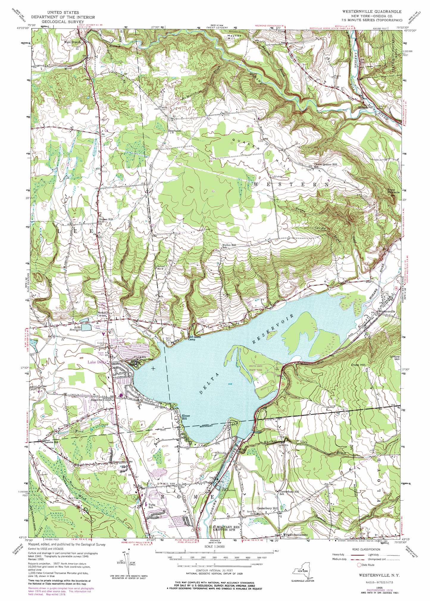
Westernville Topo Map New York
To zoom in, hover over the map of Westernville
USGS Topo Quad 43075c4 - 1:24,000 scale
| Topo Map Name: | Westernville |
| USGS Topo Quad ID: | 43075c4 |
| Print Size: | ca. 21 1/4" wide x 27" high |
| Southeast Coordinates: | 43.25° N latitude / 75.375° W longitude |
| Map Center Coordinates: | 43.3125° N latitude / 75.4375° W longitude |
| U.S. State: | NY |
| Filename: | o43075c4.jpg |
| Download Map JPG Image: | Westernville topo map 1:24,000 scale |
| Map Type: | Topographic |
| Topo Series: | 7.5´ |
| Map Scale: | 1:24,000 |
| Source of Map Images: | United States Geological Survey (USGS) |
| Alternate Map Versions: |
Westernville NY 1955, updated 1957 Download PDF Buy paper map Westernville NY 1955, updated 1968 Download PDF Buy paper map Westernville NY 1955, updated 1977 Download PDF Buy paper map Westernville NY 1955, updated 1978 Download PDF Buy paper map Westernville NY 1955, updated 1984 Download PDF Buy paper map Westernville NY 2010 Download PDF Buy paper map Westernville NY 2013 Download PDF Buy paper map Westernville NY 2016 Download PDF Buy paper map |
1:24,000 Topo Quads surrounding Westernville
North Osceola |
High Market |
Constableville |
Port Leyden |
|
Florence |
Point Rock |
West Leyden |
Boonville |
Forestport |
Camden East |
Lee Center |
Westernville |
North Western |
Remsen |
Sylvan Beach |
Verona |
Rome |
Oriskany |
South Trenton |
Oneida |
Vernon |
Clinton |
Utica West |
Utica East |
> Back to 43075a1 at 1:100,000 scale
> Back to 43074a1 at 1:250,000 scale
> Back to U.S. Topo Maps home
Westernville topo map: Gazetteer
Westernville: Populated Places
Beartown elevation 384m 1259′Canterbury Hill elevation 180m 590′
Delta Lake Trailer Court elevation 195m 639′
Elmer Hill elevation 177m 580′
Hawkins Corner elevation 177m 580′
Hillside elevation 207m 679′
Lake Delta elevation 181m 593′
Lil Fair Mobile Home Park elevation 182m 597′
Stokes Corner elevation 195m 639′
Stoneybrook Mobile Terrace elevation 203m 666′
West Branch elevation 308m 1010′
Westernville elevation 171m 561′
Wright Settlement elevation 161m 528′
Westernville: Reservoirs
Delta Reservoir elevation 167m 547′Rome Reservoir elevation 195m 639′
Westernville: Streams
Ava Brook elevation 295m 967′Big Gulf elevation 230m 754′
Deans Gulf elevation 167m 547′
East Branch Mohawk River elevation 284m 931′
Haynes Brook elevation 225m 738′
Hurlbut Glen Brook elevation 140m 459′
McMullen Brook elevation 244m 800′
Potash Creek elevation 167m 547′
Spinks Brook elevation 167m 547′
Spring Brook elevation 293m 961′
Turtle Lot Brook elevation 314m 1030′
West Branch Mohawk River elevation 284m 931′
Westernville: Summits
Dopp Hill elevation 289m 948′Haynes Hill elevation 323m 1059′
Quaker Hill elevation 403m 1322′
Tripp Pinnacle elevation 324m 1062′
Westernville digital topo map on disk
Buy this Westernville topo map showing relief, roads, GPS coordinates and other geographical features, as a high-resolution digital map file on DVD:
New York, Vermont, Connecticut & Western Massachusetts
Buy digital topo maps: New York, Vermont, Connecticut & Western Massachusetts