Otter Lake Topo Map New York
To zoom in, hover over the map of Otter Lake
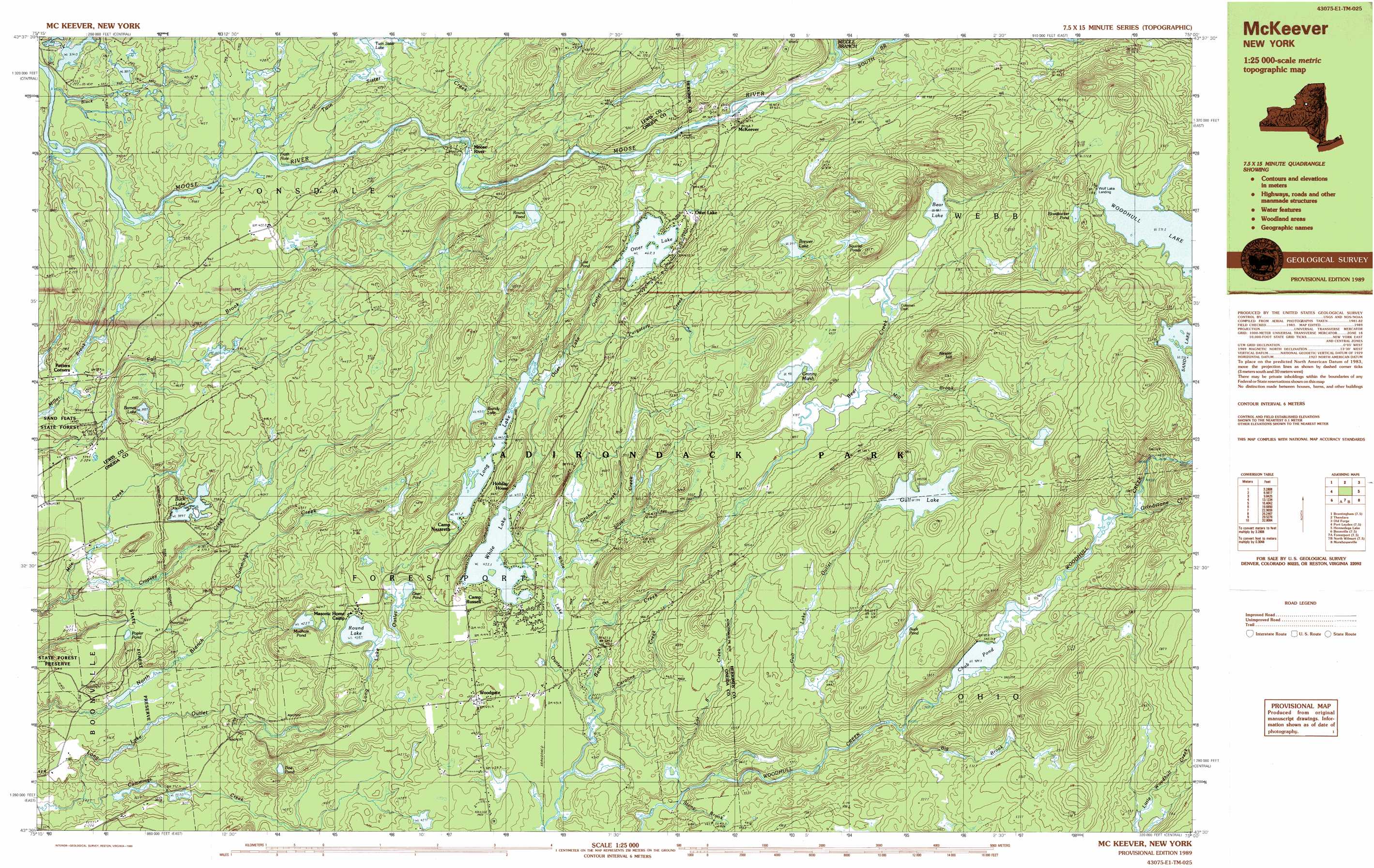
USGS Topo Quad 43075e1 - 1:25,000 scale
| Topo Map Name: | Otter Lake |
| USGS Topo Quad ID: | 43075e1 |
| Print Size: | ca. 39" wide x 24" high |
| Southeast Coordinates: | 43.5° N latitude / 75° W longitude |
| Map Center Coordinates: | 43.5625° N latitude / 75.125° W longitude |
| U.S. State: | NY |
| Filename: | k43075e1.jpg |
| Download Map JPG Image: | Otter Lake topo map 1:25,000 scale |
| Map Type: | Topographic |
| Topo Series: | 7.5´x15´ |
| Map Scale: | 1:25,000 |
| Source of Map Images: | United States Geological Survey (USGS) |
| Alternate Map Versions: |
Mc Keever NY 1989, updated 1989 Download PDF Buy paper map |
1:24,000 Topo Quads surrounding Otter Lake
Crystal Dale |
Stillwater Mountain |
Eagle Bay |
||
Brantingham |
Thendara |
Limekiln Lake |
||
Port Leyden |
Otter Lake |
Honnedaga Lake |
||
Boonville |
Forestport |
North Wilmurt |
Morehouseville |
|
North Western |
Remsen |
Hinckley |
Jerseyfield Lake |
> Back to 43075e1 at 1:100,000 scale
> Back to 43074a1 at 1:250,000 scale
> Back to U.S. Topo Maps home
Otter Lake topo map: Gazetteer
Otter Lake: Bends
Froth Hole elevation 396m 1299′Otter Lake: Dams
Coleman Dam elevation 492m 1614′Otter Lake: Lakes
Barnes Lake elevation 395m 1295′Bear Lake elevation 488m 1601′
Bloodsucker Pond elevation 592m 1942′
Brandy Lake elevation 471m 1545′
Brewer Lake elevation 541m 1774′
Buck Lake elevation 389m 1276′
Buck Pond elevation 536m 1758′
Chub Pond elevation 485m 1591′
Deer Pond elevation 431m 1414′
Doe Pond elevation 405m 1328′
Gull Lake elevation 544m 1784′
Long Lake elevation 447m 1466′
Lost Pond elevation 472m 1548′
Mudhole Pond elevation 423m 1387′
Otter Lake elevation 462m 1515′
Poplar Pond elevation 371m 1217′
Round Lake elevation 428m 1404′
Round Pond elevation 497m 1630′
Squirrel Ponds elevation 532m 1745′
Twin Sister Lake elevation 426m 1397′
White Lake elevation 435m 1427′
Otter Lake: Parks
Sand Flats State Park elevation 375m 1230′Otter Lake: Populated Places
McKeever elevation 465m 1525′Otter Lake elevation 471m 1545′
Wolf Lake Landing elevation 571m 1873′
Woodgate elevation 451m 1479′
Otter Lake: Streams
Big Brook elevation 483m 1584′Black Creek elevation 369m 1210′
Caroline Creek elevation 426m 1397′
Cropsey Creek elevation 362m 1187′
Graham Creek elevation 437m 1433′
Grindstone Creek elevation 493m 1617′
Gull Lake Outlet elevation 469m 1538′
Long Lake Outlet elevation 340m 1115′
Lot 8 Creek elevation 415m 1361′
Middle Branch Moose River elevation 461m 1512′
Mill Brook elevation 477m 1564′
Otter Lake Outlet elevation 450m 1476′
Purgatory Creek elevation 453m 1486′
Silver Creek elevation 438m 1437′
South Branch Moose River elevation 456m 1496′
Stony Brook elevation 420m 1377′
Twin Sister Creek elevation 397m 1302′
White Lake Outlet elevation 426m 1397′
Otter Lake: Summits
Neejer Hill elevation 591m 1938′Otter Lake: Swamps
Granny Marsh elevation 492m 1614′Otter Lake digital topo map on disk
Buy this Otter Lake topo map showing relief, roads, GPS coordinates and other geographical features, as a high-resolution digital map file on DVD:
New York, Vermont, Connecticut & Western Massachusetts
Buy digital topo maps: New York, Vermont, Connecticut & Western Massachusetts