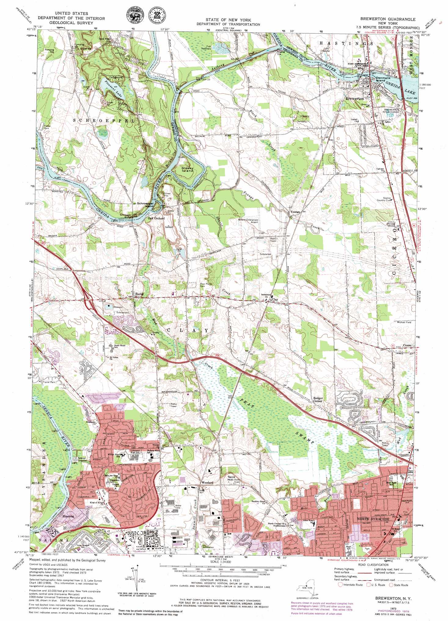
Brewerton Topo Map New York
To zoom in, hover over the map of Brewerton
USGS Topo Quad 43076b2 - 1:24,000 scale
| Topo Map Name: | Brewerton |
| USGS Topo Quad ID: | 43076b2 |
| Print Size: | ca. 21 1/4" wide x 27" high |
| Southeast Coordinates: | 43.125° N latitude / 76.125° W longitude |
| Map Center Coordinates: | 43.1875° N latitude / 76.1875° W longitude |
| U.S. State: | NY |
| Filename: | o43076b2.jpg |
| Download Map JPG Image: | Brewerton topo map 1:24,000 scale |
| Map Type: | Topographic |
| Topo Series: | 7.5´ |
| Map Scale: | 1:24,000 |
| Source of Map Images: | United States Geological Survey (USGS) |
| Alternate Map Versions: |
Brewerton NY 1940 Download PDF Buy paper map Brewerton NY 1957, updated 1959 Download PDF Buy paper map Brewerton NY 1957, updated 1965 Download PDF Buy paper map Brewerton NY 1973, updated 1974 Download PDF Buy paper map Brewerton NY 1973, updated 1979 Download PDF Buy paper map Brewerton NY 2010 Download PDF Buy paper map Brewerton NY 2013 Download PDF Buy paper map Brewerton NY 2016 Download PDF Buy paper map |
1:24,000 Topo Quads surrounding Brewerton
Oswego East |
New Haven |
Mexico |
Dugway |
Williamstown |
Fulton |
Pennellville |
Central Square |
Mallory |
Panther Lake |
Lysander |
Baldwinsville |
Brewerton |
Cicero |
Cleveland |
Jordan |
Camillus |
Syracuse West |
Syracuse East |
Manlius |
Skaneateles |
Marcellus |
South Onondaga |
Jamesville |
Oran |
> Back to 43076a1 at 1:100,000 scale
> Back to 43076a1 at 1:250,000 scale
> Back to U.S. Topo Maps home
Brewerton topo map: Gazetteer
Brewerton: Airports
Airlane Enterprises Airport elevation 114m 374′Michael Field-Onondaga Flight School Airport elevation 121m 396′
Brewerton: Areas
Ohsahaunytahseughka elevation 115m 377′Brewerton: Bridges
Schroeppel Bridge elevation 111m 364′Brewerton: Canals
Anthony Cut elevation 111m 364′Brewerton: Crossings
Brewerton Interchange elevation 116m 380′Brewerton: Dams
Lock 23 elevation 111m 364′Brewerton: Guts
Morgan Cut elevation 114m 374′Brewerton: Islands
Denmans Island elevation 113m 370′Glosky Island elevation 116m 380′
Schroeppel Island elevation 116m 380′
Brewerton: Lakes
Pleasant Lake elevation 123m 403′Brewerton: Parks
Fort Brewerton State Park elevation 116m 380′Brewerton: Populated Places
Bayberry elevation 122m 400′Brewerton elevation 117m 383′
Casual Estates elevation 113m 370′
Clay elevation 120m 393′
Elmcrest elevation 114m 374′
Euclid elevation 114m 374′
North Syracuse elevation 128m 419′
Oak Orchard elevation 112m 367′
Rodger Corner elevation 118m 387′
Woodard elevation 137m 449′
Youngs elevation 113m 370′
Brewerton: Streams
Black Creek elevation 112m 367′Mill Brook elevation 114m 374′
Mud Creek elevation 111m 364′
Shaver Creek elevation 112m 367′
Youngs Creek elevation 111m 364′
Brewerton: Summits
Terre Hill elevation 150m 492′Brewerton: Swamps
Peat Swamp elevation 114m 374′Brewerton digital topo map on disk
Buy this Brewerton topo map showing relief, roads, GPS coordinates and other geographical features, as a high-resolution digital map file on DVD:
New York, Vermont, Connecticut & Western Massachusetts
Buy digital topo maps: New York, Vermont, Connecticut & Western Massachusetts