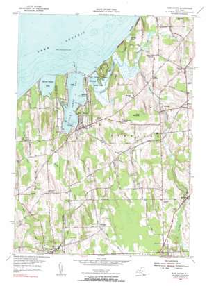
Fair Haven Topo Map New York
To zoom in, hover over the map of Fair Haven
USGS Topo Quad 43076c6 - 1:24,000 scale
| Topo Map Name: | Fair Haven |
| USGS Topo Quad ID: | 43076c6 |
| Print Size: | ca. 21 1/4" wide x 27" high |
| Southeast Coordinates: | 43.25° N latitude / 76.625° W longitude |
| Map Center Coordinates: | 43.3125° N latitude / 76.6875° W longitude |
| U.S. State: | NY |
| Filename: | o43076c6.jpg |
| Download Map JPG Image: | Fair Haven topo map 1:24,000 scale |
| Map Type: | Topographic |
| Topo Series: | 7.5´ |
| Map Scale: | 1:24,000 |
| Source of Map Images: | United States Geological Survey (USGS) |
| Alternate Map Versions: |
Fair Haven NY 1943, updated 1954 Download PDF Buy paper map Fair Haven NY 1954, updated 1956 Download PDF Buy paper map Fair Haven NY 1954, updated 1956 Download PDF Buy paper map Fair Haven NY 1954, updated 1983 Download PDF Buy paper map Fair Haven NY 2010 Download PDF Buy paper map Fair Haven NY 2013 Download PDF Buy paper map Fair Haven NY 2016 Download PDF Buy paper map |
1:24,000 Topo Quads surrounding Fair Haven
West Of Texas |
||||
West Ninemile Point |
Oswego West |
Oswego East |
||
Sodus Point |
North Wolcott |
Fair Haven |
Hannibal |
Fulton |
Rose |
Wolcott |
Victory |
Cato |
Lysander |
Lyons |
Savannah |
Montezuma |
Weedsport |
Jordan |
> Back to 43076a1 at 1:100,000 scale
> Back to 43076a1 at 1:250,000 scale
> Back to U.S. Topo Maps home
Fair Haven topo map: Gazetteer
Fair Haven: Bays
Blind Sodus Bay elevation 75m 246′Little Sodus Bay elevation 75m 246′
Meadow Cove elevation 75m 246′
Fair Haven: Capes
Eldridges Point elevation 77m 252′Fox Point elevation 81m 265′
Pearson Point elevation 75m 246′
Sabin Point elevation 78m 255′
Fair Haven: Cliffs
McIntyres Bluff elevation 86m 282′Sitts Bluff elevation 96m 314′
The Bluffs elevation 80m 262′
Fair Haven: Islands
Grass Island elevation 75m 246′Fair Haven: Lakes
Juniper Pond elevation 74m 242′The Pond elevation 75m 246′
Fair Haven: Parks
Fair Haven Beach State Park elevation 109m 357′Fair Haven: Populated Places
Crocketts elevation 109m 357′Fair Haven elevation 87m 285′
Fintches Corners elevation 118m 387′
Martville elevation 108m 354′
North Fair Haven elevation 80m 262′
North Victory elevation 130m 426′
Sterling elevation 96m 314′
Sterling Valley elevation 88m 288′
Fair Haven: Streams
Blind Sodus Creek elevation 75m 246′Sterling Creek elevation 75m 246′
Sterling Valley Creek elevation 75m 246′
Fair Haven: Summits
Gulf Hill elevation 129m 423′Juniper Hill elevation 125m 410′
Kevilles Hill elevation 126m 413′
Sidmans Hill elevation 125m 410′
The Ridge elevation 120m 393′
Wilde Hill elevation 125m 410′
Fair Haven: Swamps
Pond Hundred elevation 87m 285′The Moat elevation 75m 246′
Fair Haven digital topo map on disk
Buy this Fair Haven topo map showing relief, roads, GPS coordinates and other geographical features, as a high-resolution digital map file on DVD:
New York, Vermont, Connecticut & Western Massachusetts
Buy digital topo maps: New York, Vermont, Connecticut & Western Massachusetts


