Sandy Creek Topo Map New York
To zoom in, hover over the map of Sandy Creek
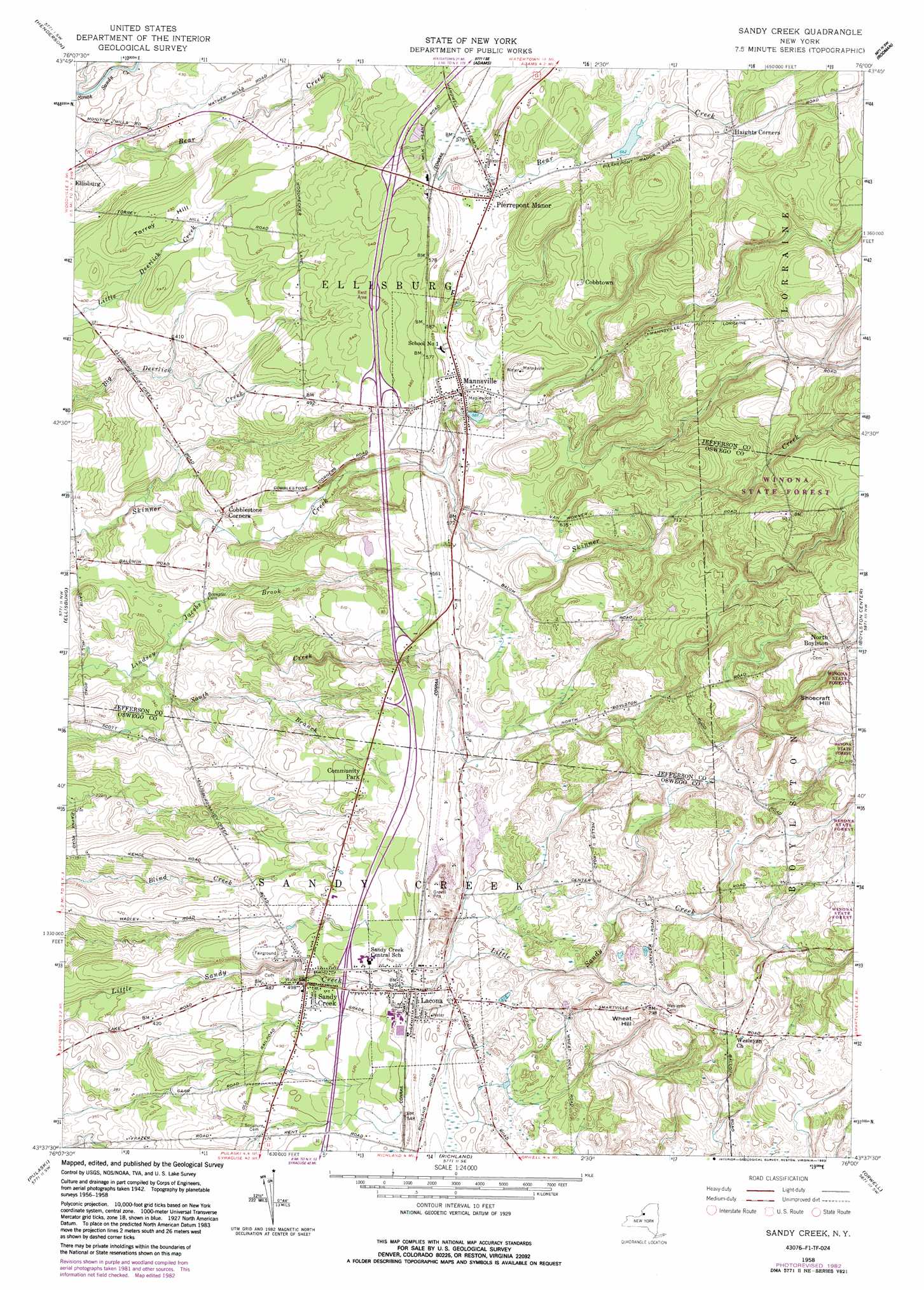
USGS Topo Quad 43076f1 - 1:24,000 scale
| Topo Map Name: | Sandy Creek |
| USGS Topo Quad ID: | 43076f1 |
| Print Size: | ca. 21 1/4" wide x 27" high |
| Southeast Coordinates: | 43.625° N latitude / 76° W longitude |
| Map Center Coordinates: | 43.6875° N latitude / 76.0625° W longitude |
| U.S. State: | NY |
| Filename: | o43076f1.jpg |
| Download Map JPG Image: | Sandy Creek topo map 1:24,000 scale |
| Map Type: | Topographic |
| Topo Series: | 7.5´ |
| Map Scale: | 1:24,000 |
| Source of Map Images: | United States Geological Survey (USGS) |
| Alternate Map Versions: |
Sandy Creek NY 1942, updated 1957 Download PDF Buy paper map Sandy Creek NY 1958, updated 1960 Download PDF Buy paper map Sandy Creek NY 1958, updated 1973 Download PDF Buy paper map Sandy Creek NY 1958, updated 1983 Download PDF Buy paper map Sandy Creek NY 1958, updated 1983 Download PDF Buy paper map Sandy Creek NY 2010 Download PDF Buy paper map Sandy Creek NY 2013 Download PDF Buy paper map Sandy Creek NY 2016 Download PDF Buy paper map |
1:24,000 Topo Quads surrounding Sandy Creek
Point Peninsula |
Henderson Bay |
Sackets Harbor |
Watertown |
Rutland Center |
Stony Point |
Henderson |
Adams |
Rodman |
Barnes Corners |
Ellisburg |
Sandy Creek |
Boylston Center |
Worth Center |
|
Texas |
Pulaski |
Richland |
Orwell |
Redfield |
New Haven |
Mexico |
Dugway |
Williamstown |
Westdale |
> Back to 43076e1 at 1:100,000 scale
> Back to 43076a1 at 1:250,000 scale
> Back to U.S. Topo Maps home
Sandy Creek topo map: Gazetteer
Sandy Creek: Populated Places
Cobbtown elevation 220m 721′Community Park elevation 156m 511′
Lacona elevation 170m 557′
Mannsville elevation 189m 620′
North Boylston elevation 300m 984′
Pierrepont Manor elevation 190m 623′
Sandy Creek elevation 152m 498′
Sandy Creek: Streams
Jacobs Brook elevation 100m 328′South Branch Lindsey Creek elevation 94m 308′
Sandy Creek: Summits
Shoecraft Hill elevation 327m 1072′Torrey Hill elevation 150m 492′
Wheat Hill elevation 247m 810′
Sandy Creek digital topo map on disk
Buy this Sandy Creek topo map showing relief, roads, GPS coordinates and other geographical features, as a high-resolution digital map file on DVD:
New York, Vermont, Connecticut & Western Massachusetts
Buy digital topo maps: New York, Vermont, Connecticut & Western Massachusetts