Adams Topo Map New York
To zoom in, hover over the map of Adams
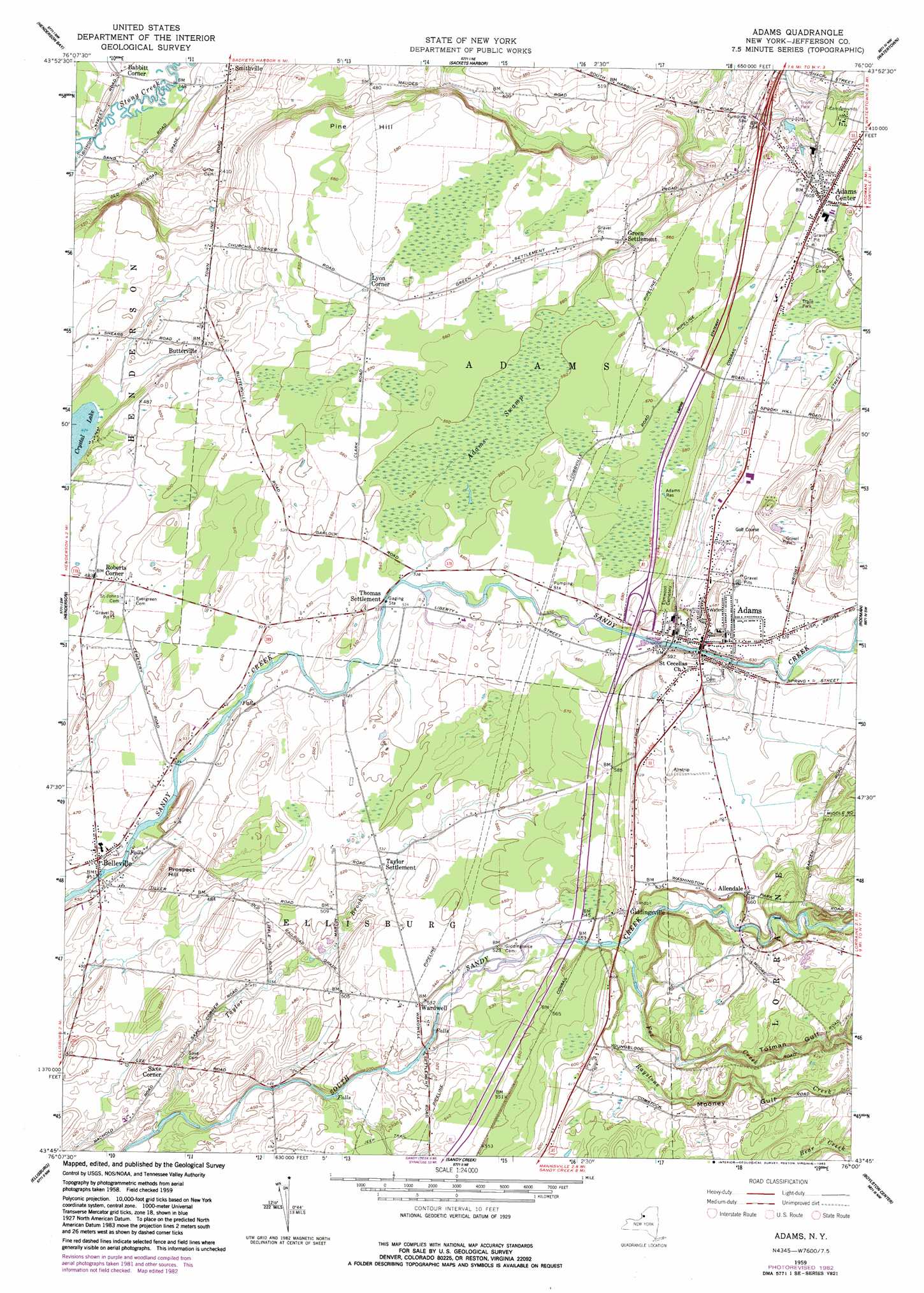
USGS Topo Quad 43076g1 - 1:24,000 scale
| Topo Map Name: | Adams |
| USGS Topo Quad ID: | 43076g1 |
| Print Size: | ca. 21 1/4" wide x 27" high |
| Southeast Coordinates: | 43.75° N latitude / 76° W longitude |
| Map Center Coordinates: | 43.8125° N latitude / 76.0625° W longitude |
| U.S. State: | NY |
| Filename: | o43076g1.jpg |
| Download Map JPG Image: | Adams topo map 1:24,000 scale |
| Map Type: | Topographic |
| Topo Series: | 7.5´ |
| Map Scale: | 1:24,000 |
| Source of Map Images: | United States Geological Survey (USGS) |
| Alternate Map Versions: |
Adams NY 1959, updated 1961 Download PDF Buy paper map Adams NY 1959, updated 1976 Download PDF Buy paper map Adams NY 1959, updated 1983 Download PDF Buy paper map Adams NY 2010 Download PDF Buy paper map Adams NY 2013 Download PDF Buy paper map Adams NY 2016 Download PDF Buy paper map |
1:24,000 Topo Quads surrounding Adams
Cape Vincent South |
Chaumont |
Dexter |
Brownville |
Black River |
Point Peninsula |
Henderson Bay |
Sackets Harbor |
Watertown |
Rutland Center |
Stony Point |
Henderson |
Adams |
Rodman |
Barnes Corners |
Ellisburg |
Sandy Creek |
Boylston Center |
Worth Center |
|
Texas |
Pulaski |
Richland |
Orwell |
Redfield |
> Back to 43076e1 at 1:100,000 scale
> Back to 43076a1 at 1:250,000 scale
> Back to U.S. Topo Maps home
Adams topo map: Gazetteer
Adams: Lakes
Crystal Lake elevation 129m 423′Adams: Parks
Firemen's Park elevation 187m 613′Adams: Populated Places
Adams elevation 187m 613′Adams Center elevation 195m 639′
Allendale elevation 201m 659′
Babbitt Corner elevation 106m 347′
Belleville elevation 140m 459′
Butterville elevation 144m 472′
Giddingsville elevation 182m 597′
Green Settlement elevation 168m 551′
Lyon Corner elevation 171m 561′
Roberts Corner elevation 148m 485′
Saxe Corner elevation 141m 462′
Taylor Settlement elevation 159m 521′
Thomas Settlement elevation 162m 531′
Wardwell elevation 162m 531′
Adams: Reservoirs
Adams Reservoir elevation 178m 583′Adams: Streams
Fox Creek elevation 169m 554′Raystone Creek elevation 170m 557′
Taylor Brook elevation 115m 377′
Adams: Summits
Pine Hill elevation 174m 570′Prospect Hill elevation 163m 534′
Adams: Swamps
Adams Swamp elevation 166m 544′Adams: Valleys
Mooney Gulf elevation 194m 636′Totman Gulf elevation 191m 626′
Adams digital topo map on disk
Buy this Adams topo map showing relief, roads, GPS coordinates and other geographical features, as a high-resolution digital map file on DVD:
New York, Vermont, Connecticut & Western Massachusetts
Buy digital topo maps: New York, Vermont, Connecticut & Western Massachusetts