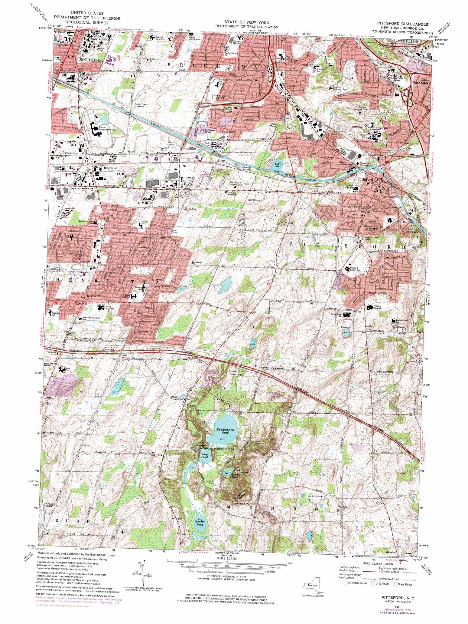
Pittsford Topo Map New York
To zoom in, hover over the map of Pittsford
USGS Topo Quad 43077a5 - 1:24,000 scale
| Topo Map Name: | Pittsford |
| USGS Topo Quad ID: | 43077a5 |
| Print Size: | ca. 21 1/4" wide x 27" high |
| Southeast Coordinates: | 43° N latitude / 77.5° W longitude |
| Map Center Coordinates: | 43.0625° N latitude / 77.5625° W longitude |
| U.S. State: | NY |
| Filename: | o43077a5.jpg |
| Download Map JPG Image: | Pittsford topo map 1:24,000 scale |
| Map Type: | Topographic |
| Topo Series: | 7.5´ |
| Map Scale: | 1:24,000 |
| Source of Map Images: | United States Geological Survey (USGS) |
| Alternate Map Versions: |
Mendon Ponds NY 1931 Download PDF Buy paper map Mendon Ponds NY 1935 Download PDF Buy paper map Mendon Ponds NY 1935 Download PDF Buy paper map Mendon Ponds NY 1935, updated 1947 Download PDF Buy paper map Mendon Ponds NY 1952, updated 1954 Download PDF Buy paper map Mendon Ponds NY 1952, updated 1959 Download PDF Buy paper map Mendon Ponds NY 1952, updated 1970 Download PDF Buy paper map Pittsford NY 1971, updated 1974 Download PDF Buy paper map Pittsford NY 1971, updated 1978 Download PDF Buy paper map Pittsford NY 1971, updated 1978 Download PDF Buy paper map Pittsford NY 1994, updated 2000 Download PDF Buy paper map Pittsford NY 2010 Download PDF Buy paper map Pittsford NY 2013 Download PDF Buy paper map Pittsford NY 2016 Download PDF Buy paper map |
1:24,000 Topo Quads surrounding Pittsford
Hilton |
Braddock Heights |
Ninemile Point |
Furnaceville |
|
Spencerport |
Rochester West |
Rochester East |
Webster |
Ontario |
Clifton |
West Henrietta |
Pittsford |
Fairport |
Macedon |
Caledonia |
Rush |
Honeoye Falls |
Victor |
Canandaigua |
Geneseo |
Livonia |
Honeoye |
Bristol Center |
Canandaigua Lake |
> Back to 43077a1 at 1:100,000 scale
> Back to 43076a1 at 1:250,000 scale
> Back to U.S. Topo Maps home
Pittsford topo map: Gazetteer
Pittsford: Airports
Strong Memorial Hospital Heliport elevation 165m 541′Pittsford: Basins
Woodchuck Hollow elevation 203m 666′Pittsford: Dams
Lock 32 elevation 144m 472′Pittsford: Lakes
Deep Pond elevation 196m 643′Devils Bathtub elevation 198m 649′
Hundred Acre Pond elevation 196m 643′
Lost Pond elevation 197m 646′
Quaker Pond elevation 193m 633′
Round Pond elevation 198m 649′
Pittsford: Parks
Dugan Yard elevation 135m 442′Golden Flyer Stadium elevation 128m 419′
Growney Stadium elevation 132m 433′
Veterans Memorial Park elevation 168m 551′
Pittsford: Populated Places
Henrietta elevation 183m 600′Pittsford elevation 150m 492′
Ridgeland elevation 160m 524′
West Brighton elevation 174m 570′
Pittsford: Streams
East Branch Allen Creek elevation 119m 390′West Brook elevation 125m 410′
Pittsford digital topo map on disk
Buy this Pittsford topo map showing relief, roads, GPS coordinates and other geographical features, as a high-resolution digital map file on DVD:
New York, Vermont, Connecticut & Western Massachusetts
Buy digital topo maps: New York, Vermont, Connecticut & Western Massachusetts