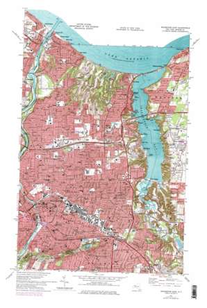
Rochester East Topo Map New York
To zoom in, hover over the map of Rochester East
USGS Topo Quad 43077b5 - 1:24,000 scale
| Topo Map Name: | Rochester East |
| USGS Topo Quad ID: | 43077b5 |
| Print Size: | ca. 21 1/4" wide x 27" high |
| Southeast Coordinates: | 43.125° N latitude / 77.5° W longitude |
| Map Center Coordinates: | 43.1875° N latitude / 77.5625° W longitude |
| U.S. State: | NY |
| Filename: | o43077b5.jpg |
| Download Map JPG Image: | Rochester East topo map 1:24,000 scale |
| Map Type: | Topographic |
| Topo Series: | 7.5´ |
| Map Scale: | 1:24,000 |
| Source of Map Images: | United States Geological Survey (USGS) |
| Alternate Map Versions: |
Rochester East NY 1931 Download PDF Buy paper map Rochester East NY 1935 Download PDF Buy paper map Rochester East NY 1935, updated 1945 Download PDF Buy paper map Rochester East NY 1935, updated 1950 Download PDF Buy paper map Rochester East NY 1952, updated 1954 Download PDF Buy paper map Rochester East NY 1952, updated 1961 Download PDF Buy paper map Rochester East NY 1952, updated 1970 Download PDF Buy paper map Rochester East NY 1971, updated 1974 Download PDF Buy paper map Rochester East NY 1971, updated 1979 Download PDF Buy paper map Rochester East NY 1971, updated 1979 Download PDF Buy paper map Rochester East NY 2010 Download PDF Buy paper map Rochester East NY 2013 Download PDF Buy paper map Rochester East NY 2016 Download PDF Buy paper map |
1:24,000 Topo Quads surrounding Rochester East
> Back to 43077a1 at 1:100,000 scale
> Back to 43076a1 at 1:250,000 scale
> Back to U.S. Topo Maps home
Rochester East topo map: Gazetteer
Rochester East: Bays
Big Massaug Cove elevation 74m 242′Helds Cove elevation 74m 242′
Ides Cove elevation 74m 242′
Irondequoit Bay elevation 74m 242′
Rochester East: Bridges
Frederick Douglass-Susan B. Anthony Memorial Bridge elevation 156m 511′Irondequoit Bay Bridge elevation 74m 242′
Irondequoit Bay Outlet Bridge elevation 74m 242′
Veterans Memorial Bridge elevation 74m 242′
Rochester East: Capes
Birds and Worms elevation 74m 242′Inspiration Point elevation 121m 396′
Point Lookout elevation 76m 249′
Point Pleasant elevation 78m 255′
Rattlesnake Point elevation 81m 265′
Stony Point elevation 74m 242′
Rochester East: Islands
Snider Island elevation 75m 246′Rochester East: Lakes
Durand Lake elevation 82m 269′Eastman Lake elevation 78m 255′
Lake Riley elevation 152m 498′
Rochester East: Parks
Cobbs Hill Park elevation 188m 616′Durand Eastman Park elevation 99m 324′
Ellison Park elevation 76m 249′
Highland Park elevation 182m 597′
Irondequoit Bay Park elevation 98m 321′
Pulaski Park elevation 146m 479′
Seneca Park elevation 96m 314′
Silver Stadium (historical) elevation 136m 446′
Rochester East: Populated Places
Bay View elevation 74m 242′Brighton elevation 136m 446′
Cobbs Hill elevation 165m 541′
Forest Lawn elevation 80m 262′
German Village elevation 112m 367′
Glen Edith elevation 76m 249′
Glen Haven elevation 78m 255′
Harper Park Rochester elevation 136m 446′
Irondequoit elevation 116m 380′
Newport elevation 87m 285′
Oklahoma Beach elevation 77m 252′
Rochester elevation 154m 505′
Rock Beach elevation 78m 255′
Sea Breeze elevation 98m 321′
Sebastian Mobile Home Park elevation 135m 442′
Twelve Corners elevation 150m 492′
Rochester East: Reservoirs
Buell Pond (historical) elevation 120m 393′Cobbs Hill Reservoir elevation 193m 633′
Rochester East: Streams
Allen Creek elevation 85m 278′Densmore Creek elevation 74m 242′
Hobbie Creek elevation 90m 295′
Irondequoit Creek elevation 74m 242′
Rochester East: Summits
Cobbs Hill elevation 192m 629′Pinnacle Hill elevation 224m 734′
Rochester East digital topo map on disk
Buy this Rochester East topo map showing relief, roads, GPS coordinates and other geographical features, as a high-resolution digital map file on DVD:
New York, Vermont, Connecticut & Western Massachusetts
Buy digital topo maps: New York, Vermont, Connecticut & Western Massachusetts


