Spencerport Topo Map New York
To zoom in, hover over the map of Spencerport
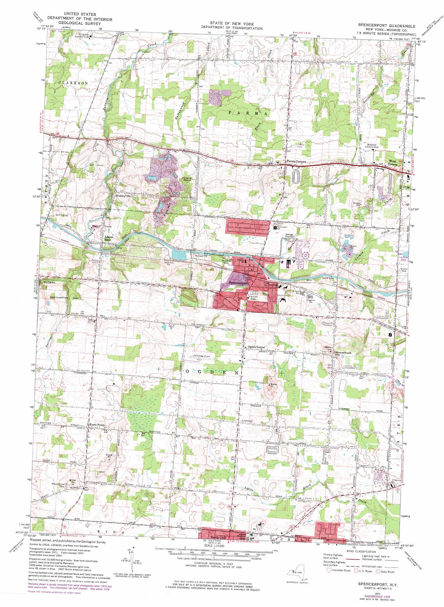
USGS Topo Quad 43077b7 - 1:24,000 scale
| Topo Map Name: | Spencerport |
| USGS Topo Quad ID: | 43077b7 |
| Print Size: | ca. 21 1/4" wide x 27" high |
| Southeast Coordinates: | 43.125° N latitude / 77.75° W longitude |
| Map Center Coordinates: | 43.1875° N latitude / 77.8125° W longitude |
| U.S. State: | NY |
| Filename: | o43077b7.jpg |
| Download Map JPG Image: | Spencerport topo map 1:24,000 scale |
| Map Type: | Topographic |
| Topo Series: | 7.5´ |
| Map Scale: | 1:24,000 |
| Source of Map Images: | United States Geological Survey (USGS) |
| Alternate Map Versions: |
Spencerport NY 1932 Download PDF Buy paper map Spencerport NY 1934 Download PDF Buy paper map Spencerport NY 1934 Download PDF Buy paper map Spencerport NY 1952, updated 1953 Download PDF Buy paper map Spencerport NY 1952, updated 1960 Download PDF Buy paper map Spencerport NY 1952, updated 1970 Download PDF Buy paper map Spencerport NY 1971, updated 1974 Download PDF Buy paper map Spencerport NY 1971, updated 1978 Download PDF Buy paper map Spencerport NY 2010 Download PDF Buy paper map Spencerport NY 2013 Download PDF Buy paper map Spencerport NY 2016 Download PDF Buy paper map |
1:24,000 Topo Quads surrounding Spencerport
Kendall |
Hamlin |
Hilton |
Braddock Heights |
|
Holley |
Brockport |
Spencerport |
Rochester West |
Rochester East |
Byron |
Churchville |
Clifton |
West Henrietta |
Pittsford |
Stafford |
Le Roy |
Caledonia |
Rush |
Honeoye Falls |
> Back to 43077a1 at 1:100,000 scale
> Back to 43076a1 at 1:250,000 scale
> Back to U.S. Topo Maps home
Spencerport topo map: Gazetteer
Spencerport: Airports
Spencerport Airpark elevation 186m 610′Spencerport: Populated Places
Adams Basin elevation 153m 501′Catfield elevation 131m 429′
Hinkleyville elevation 144m 472′
Ogden Center elevation 187m 613′
Parma Corners elevation 132m 433′
September Place Mobile Home Park elevation 128m 419′
Spencerport elevation 169m 554′
Town Pump elevation 196m 643′
West Greece elevation 130m 426′
Spencerport: Streams
Spring Creek elevation 161m 528′Spencerport: Summits
Pine Hill elevation 166m 544′Woodchuck Hill elevation 200m 656′
Spencerport digital topo map on disk
Buy this Spencerport topo map showing relief, roads, GPS coordinates and other geographical features, as a high-resolution digital map file on DVD:
New York, Vermont, Connecticut & Western Massachusetts
Buy digital topo maps: New York, Vermont, Connecticut & Western Massachusetts