Argyle Topo Map Michigan
To zoom in, hover over the map of Argyle
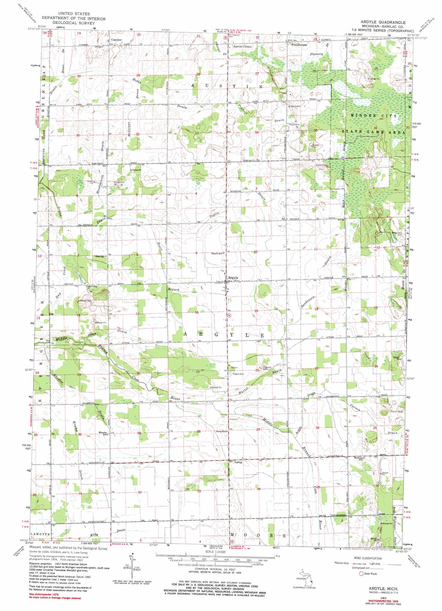
USGS Topo Quad 43082e8 - 1:24,000 scale
| Topo Map Name: | Argyle |
| USGS Topo Quad ID: | 43082e8 |
| Print Size: | ca. 21 1/4" wide x 27" high |
| Southeast Coordinates: | 43.5° N latitude / 82.875° W longitude |
| Map Center Coordinates: | 43.5625° N latitude / 82.9375° W longitude |
| U.S. State: | MI |
| Filename: | o43082e8.jpg |
| Download Map JPG Image: | Argyle topo map 1:24,000 scale |
| Map Type: | Topographic |
| Topo Series: | 7.5´ |
| Map Scale: | 1:24,000 |
| Source of Map Images: | United States Geological Survey (USGS) |
| Alternate Map Versions: |
Argyle MI 1963, updated 1964 Download PDF Buy paper map Argyle MI 1963, updated 1982 Download PDF Buy paper map Argyle MI 2011 Download PDF Buy paper map Argyle MI 2014 Download PDF Buy paper map Argyle MI 2016 Download PDF Buy paper map |
1:24,000 Topo Quads surrounding Argyle
Elkton |
Bad Axe West |
Bad Axe East |
Bad Axe Se |
Harbor Beach |
Gagetown |
New Greenleaf |
Ubly |
Minden City |
Ruth |
Cass City |
Shabbona |
Argyle |
Palms |
Deckerville |
Kingston |
Decker |
Snover |
Sandusky |
Carsonville |
Clifford |
Marlette |
Juhl |
Peck |
Applegate |
> Back to 43082e1 at 1:100,000 scale
> Back to 43082a1 at 1:250,000 scale
> Back to U.S. Topo Maps home
Argyle topo map: Gazetteer
Argyle: Canals
Brice Wightman Drain elevation 235m 770′Main Hartel Drain elevation 238m 780′
Argyle: Populated Places
Argyle elevation 241m 790′Austin Center elevation 241m 790′
Cumber elevation 247m 810′
Freidberger elevation 241m 790′
Laing elevation 233m 764′
Argyle: Post Offices
Argyle Post Office elevation 241m 790′Cumber Post Office (historical) elevation 247m 810′
Freiburgers Post Office (historical) elevation 240m 787′
Laing Post Office (historical) elevation 233m 764′
Argyle: Streams
Argyle Drain elevation 232m 761′Brown Drain elevation 232m 761′
Carson Drain elevation 235m 770′
Flannery Drain elevation 237m 777′
Franzel Drain elevation 235m 770′
Hartel Drain elevation 231m 757′
Hawksworth Drain elevation 232m 761′
Hobbs Drain elevation 232m 761′
Ingles Drain elevation 229m 751′
McIntyre Drain elevation 234m 767′
Sanderson Drain elevation 235m 770′
Swan Drain elevation 228m 748′
Wheeler Drain elevation 225m 738′
Argyle: Valleys
South Branch Ingles Draw elevation 234m 767′Argyle digital topo map on disk
Buy this Argyle topo map showing relief, roads, GPS coordinates and other geographical features, as a high-resolution digital map file on DVD:
 map DVD")