Burnside Topo Map Michigan
To zoom in, hover over the map of Burnside
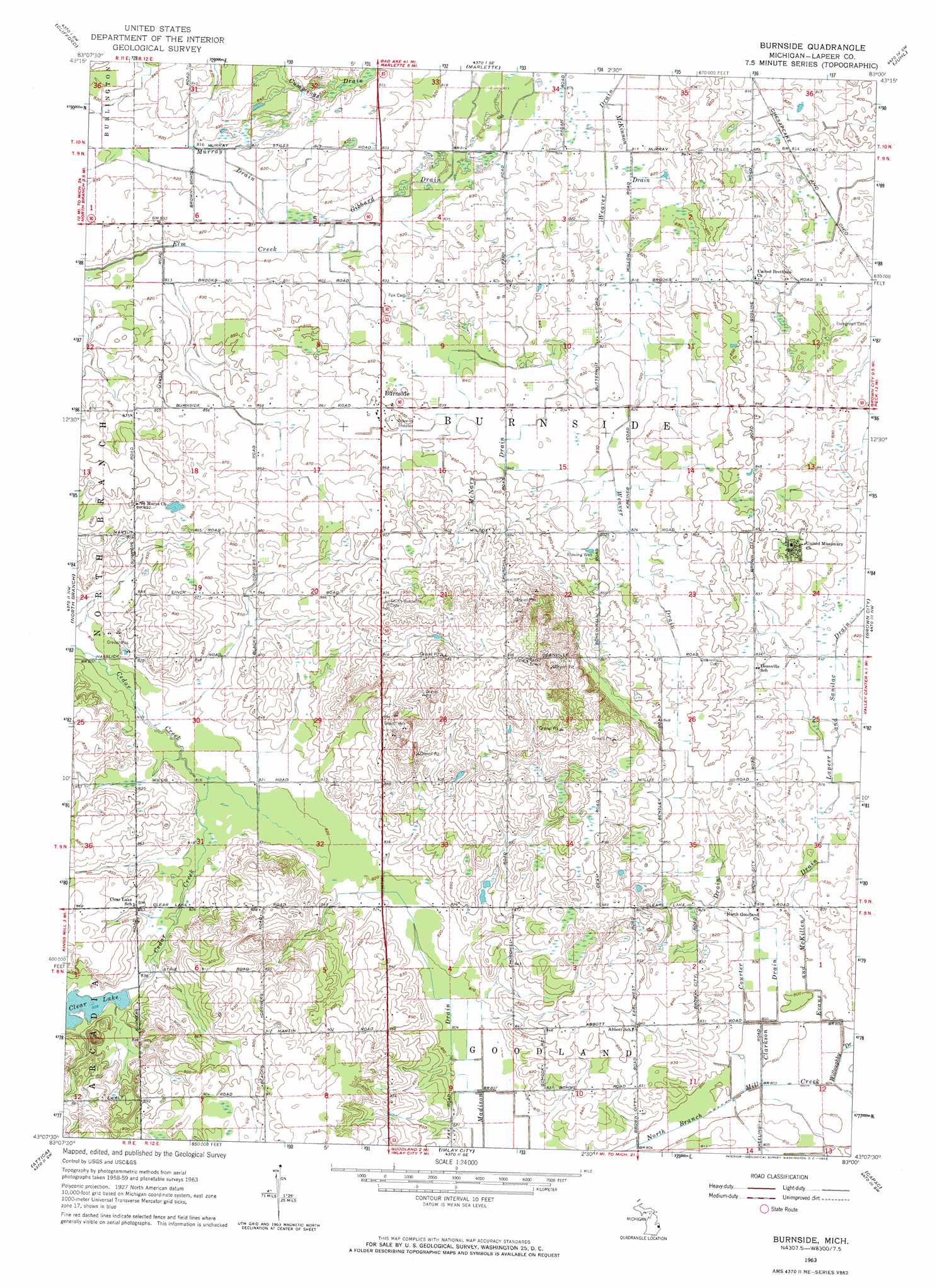
USGS Topo Quad 43083b1 - 1:24,000 scale
| Topo Map Name: | Burnside |
| USGS Topo Quad ID: | 43083b1 |
| Print Size: | ca. 21 1/4" wide x 27" high |
| Southeast Coordinates: | 43.125° N latitude / 83° W longitude |
| Map Center Coordinates: | 43.1875° N latitude / 83.0625° W longitude |
| U.S. State: | MI |
| Filename: | o43083b1.jpg |
| Download Map JPG Image: | Burnside topo map 1:24,000 scale |
| Map Type: | Topographic |
| Topo Series: | 7.5´ |
| Map Scale: | 1:24,000 |
| Source of Map Images: | United States Geological Survey (USGS) |
| Alternate Map Versions: |
Burnside MI 1963, updated 1964 Download PDF Buy paper map Burnside MI 1963, updated 1964 Download PDF Buy paper map Burnside MI 2011 Download PDF Buy paper map Burnside MI 2014 Download PDF Buy paper map Burnside MI 2017 Download PDF Buy paper map |
1:24,000 Topo Quads surrounding Burnside
East Dayton |
Kingston |
Decker |
Snover |
Sandusky |
Mayville |
Clifford |
Marlette |
Juhl |
Peck |
Barnes Lake |
North Branch |
Burnside |
Brown City |
Yale |
Lapeer |
Attica |
Imlay City |
Capac |
Brockway |
Metamora |
Thornville |
Almont |
Allenton |
Memphis |
> Back to 43083a1 at 1:100,000 scale
> Back to 43082a1 at 1:250,000 scale
> Back to U.S. Topo Maps home
Burnside topo map: Gazetteer
Burnside: Canals
Clarkson Drain elevation 244m 800′Courter Drain elevation 247m 810′
Cummings Drain elevation 256m 839′
Evans and McKillen Drain elevation 247m 810′
Gibbard Drain elevation 247m 810′
Madison Drain elevation 244m 800′
McKimmon Drain elevation 247m 810′
McNary Drain elevation 257m 843′
Murray Drain elevation 250m 820′
Weaver Drain elevation 252m 826′
Weaver Drain elevation 250m 820′
Burnside: Lakes
Clear Lake elevation 252m 826′Burnside: Populated Places
Burnside elevation 259m 849′Burnside: Post Offices
Burnside Post Office (historical) elevation 259m 849′Deanville Post Office (historical) elevation 253m 830′
Index Post Office (historical) elevation 253m 830′
Burnside digital topo map on disk
Buy this Burnside topo map showing relief, roads, GPS coordinates and other geographical features, as a high-resolution digital map file on DVD:
 map DVD")