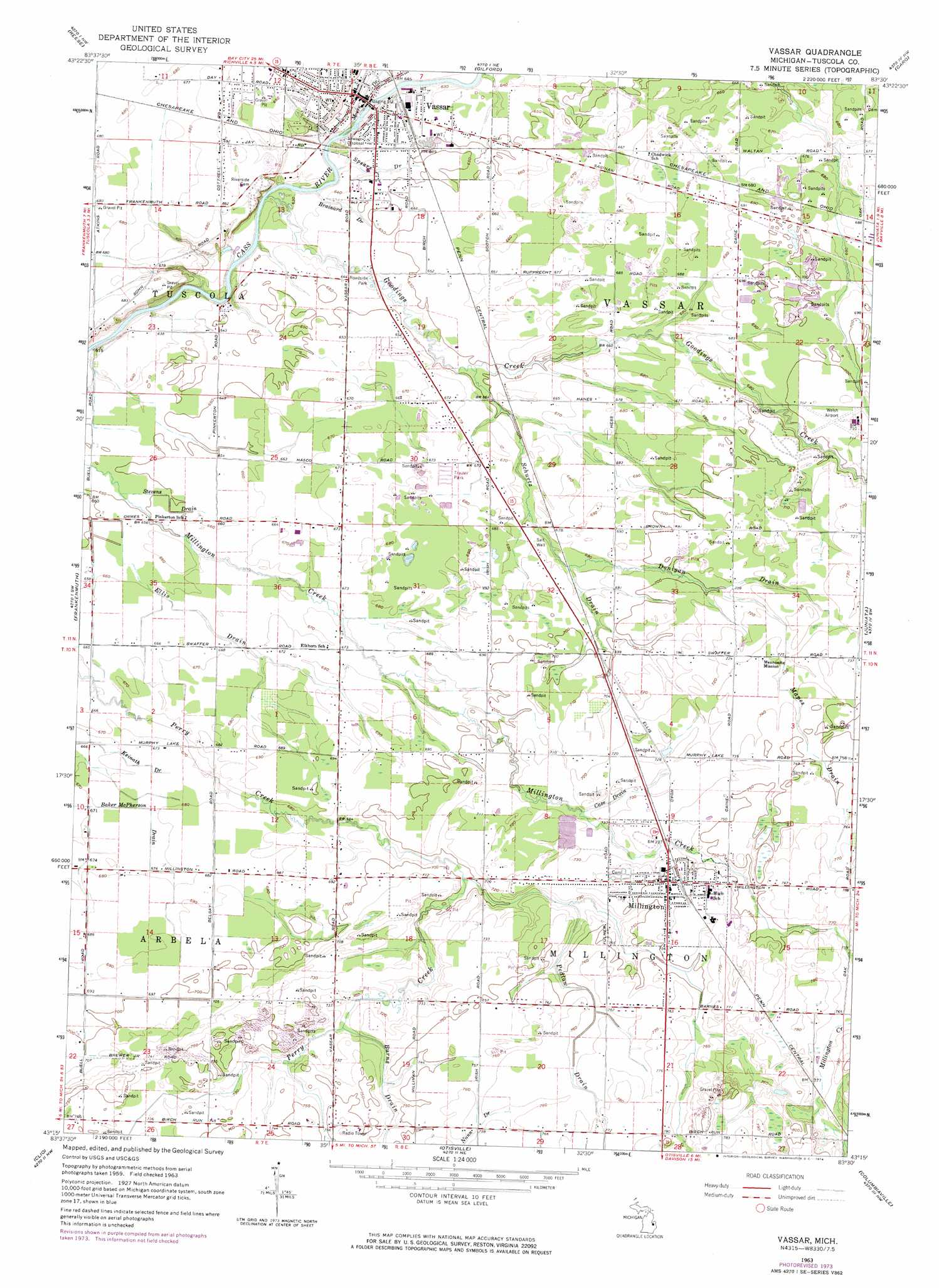
Vassar Topo Map Michigan
To zoom in, hover over the map of Vassar
USGS Topo Quad 43083c5 - 1:24,000 scale
| Topo Map Name: | Vassar |
| USGS Topo Quad ID: | 43083c5 |
| Print Size: | ca. 21 1/4" wide x 27" high |
| Southeast Coordinates: | 43.25° N latitude / 83.5° W longitude |
| Map Center Coordinates: | 43.3125° N latitude / 83.5625° W longitude |
| U.S. State: | MI |
| Filename: | o43083c5.jpg |
| Download Map JPG Image: | Vassar topo map 1:24,000 scale |
| Map Type: | Topographic |
| Topo Series: | 7.5´ |
| Map Scale: | 1:24,000 |
| Source of Map Images: | United States Geological Survey (USGS) |
| Alternate Map Versions: |
Vassar MI 1963, updated 1964 Download PDF Buy paper map Vassar MI 1963, updated 1974 Download PDF Buy paper map Vassar MI 2011 Download PDF Buy paper map Vassar MI 2014 Download PDF Buy paper map Vassar MI 2017 Download PDF Buy paper map |
1:24,000 Topo Quads surrounding Vassar
Essexville |
Quanicassee |
Fairgrove |
Colling |
Ellington |
Saginaw Ne |
Reese |
Gilford |
Caro |
East Dayton |
Birch Run North |
Frankenmuth |
Vassar |
Juniata |
Mayville |
Birch Run South |
Clio |
Otisville |
Columbiaville |
Barnes Lake |
Flushing |
Flint North |
Davison |
Elba |
Lapeer |
> Back to 43083a1 at 1:100,000 scale
> Back to 43082a1 at 1:250,000 scale
> Back to U.S. Topo Maps home
Vassar topo map: Gazetteer
Vassar: Airports
Jensen Field elevation 230m 754′Tanke Field elevation 204m 669′
Vassar: Canals
Brainard Drain elevation 195m 639′Case Drain elevation 220m 721′
Donigan Drain elevation 216m 708′
Keinath Drain elevation 204m 669′
Mapes Drain elevation 225m 738′
Pedlow Drain elevation 229m 751′
Schurtz Drain elevation 204m 669′
Spears Drain elevation 195m 639′
Stevens Drain elevation 198m 649′
Vassar: Parks
Arthur Latham Park elevation 223m 731′Millington Bank Historical Marker elevation 230m 754′
Millington School District Number Two Historical Marker elevation 232m 761′
Silas A Lane House Historical Marker elevation 209m 685′
Vassar's Logging Era Historical Marker elevation 192m 629′
Wightman Building Historical Marker elevation 195m 639′
Vassar: Populated Places
Millington elevation 229m 751′Partridge's RV and Mobile Home Park elevation 196m 643′
Vassar elevation 195m 639′
Woodvalley Mobile Home Park elevation 205m 672′
Vassar: Post Offices
Millington Post Office elevation 229m 751′Vassar Post Office elevation 196m 643′
Vassar: Streams
Goodings Creek elevation 190m 623′Moore Drain elevation 189m 620′
Vassar digital topo map on disk
Buy this Vassar topo map showing relief, roads, GPS coordinates and other geographical features, as a high-resolution digital map file on DVD:
 map DVD")