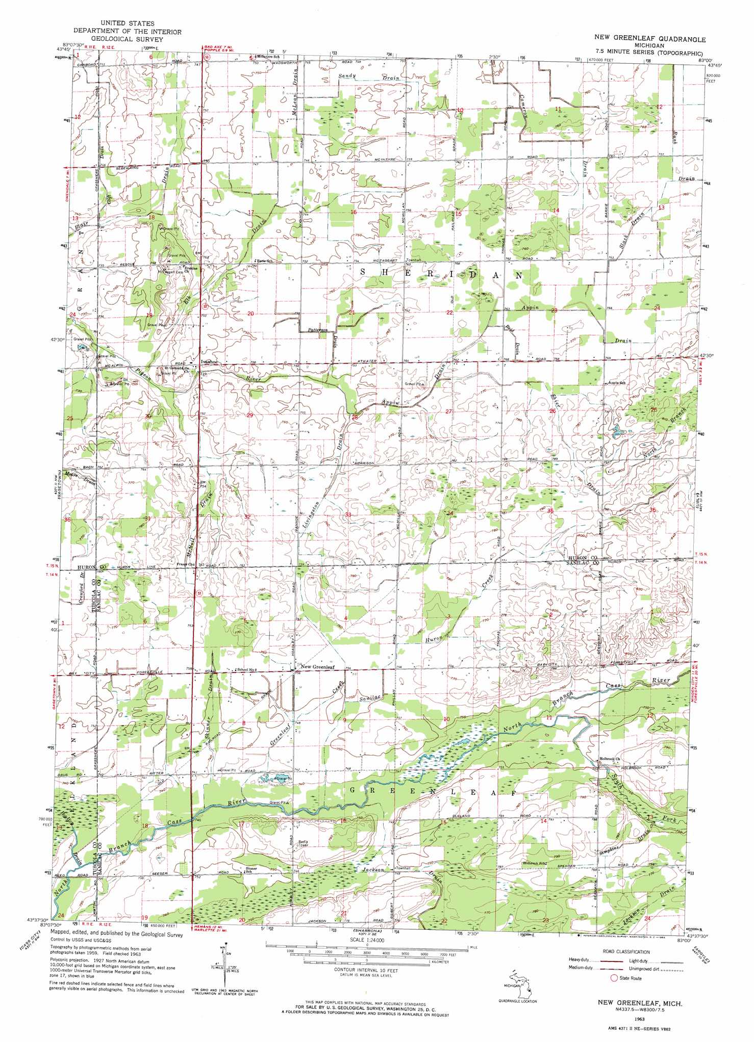
New Greenleaf Topo Map Michigan
To zoom in, hover over the map of New Greenleaf
USGS Topo Quad 43083f1 - 1:24,000 scale
| Topo Map Name: | New Greenleaf |
| USGS Topo Quad ID: | 43083f1 |
| Print Size: | ca. 21 1/4" wide x 27" high |
| Southeast Coordinates: | 43.625° N latitude / 83° W longitude |
| Map Center Coordinates: | 43.6875° N latitude / 83.0625° W longitude |
| U.S. State: | MI |
| Filename: | o43083f1.jpg |
| Download Map JPG Image: | New Greenleaf topo map 1:24,000 scale |
| Map Type: | Topographic |
| Topo Series: | 7.5´ |
| Map Scale: | 1:24,000 |
| Source of Map Images: | United States Geological Survey (USGS) |
| Alternate Map Versions: |
New Greenleaf MI 1963, updated 1964 Download PDF Buy paper map New Greenleaf MI 2011 Download PDF Buy paper map New Greenleaf MI 2014 Download PDF Buy paper map New Greenleaf MI 2017 Download PDF Buy paper map |
1:24,000 Topo Quads surrounding New Greenleaf
Caseville |
Rush Lake |
Kinde West |
Kinde East |
Redman |
Bay Port East |
Elkton |
Bad Axe West |
Bad Axe East |
Bad Axe Se |
Owendale |
Gagetown |
New Greenleaf |
Ubly |
Minden City |
Ellington |
Cass City |
Shabbona |
Argyle |
Palms |
East Dayton |
Kingston |
Decker |
Snover |
Sandusky |
> Back to 43083e1 at 1:100,000 scale
> Back to 43082a1 at 1:250,000 scale
> Back to U.S. Topo Maps home
New Greenleaf topo map: Gazetteer
New Greenleaf: Canals
Appin Drain elevation 232m 761′Blair Drain elevation 224m 734′
Clift Drain elevation 226m 741′
Elk Drain elevation 226m 741′
Livingston Drain elevation 229m 751′
McNeil Drain elevation 228m 748′
North Branch Shier Drain elevation 244m 800′
Patterson Drain elevation 228m 748′
Reid Drain elevation 231m 757′
Sandy Drain elevation 228m 748′
Shier Drain elevation 237m 777′
Simpkins Drain elevation 232m 761′
Skinner Drain elevation 226m 741′
Slack Drain elevation 232m 761′
New Greenleaf: Parks
Sanilac Petroglyphs Historic State Park elevation 229m 751′Sanilac State Game Area elevation 232m 761′
New Greenleaf: Populated Places
Ivanhoe elevation 228m 748′New Greenleaf elevation 229m 751′
New Greenleaf: Post Offices
Appin Post Office (historical) elevation 232m 761′Greenleaf Post Office (historical) elevation 229m 751′
Holbrook Post Office (historical) elevation 228m 748′
Ivanhoe Post Office (historical) elevation 228m 748′
Northburns Post Office (historical) elevation 226m 741′
New Greenleaf: Streams
Greenleaf Creek elevation 222m 728′Sanilac Huron Creek elevation 222m 728′
South Fork Cass River elevation 225m 738′
New Greenleaf digital topo map on disk
Buy this New Greenleaf topo map showing relief, roads, GPS coordinates and other geographical features, as a high-resolution digital map file on DVD:
 map DVD")