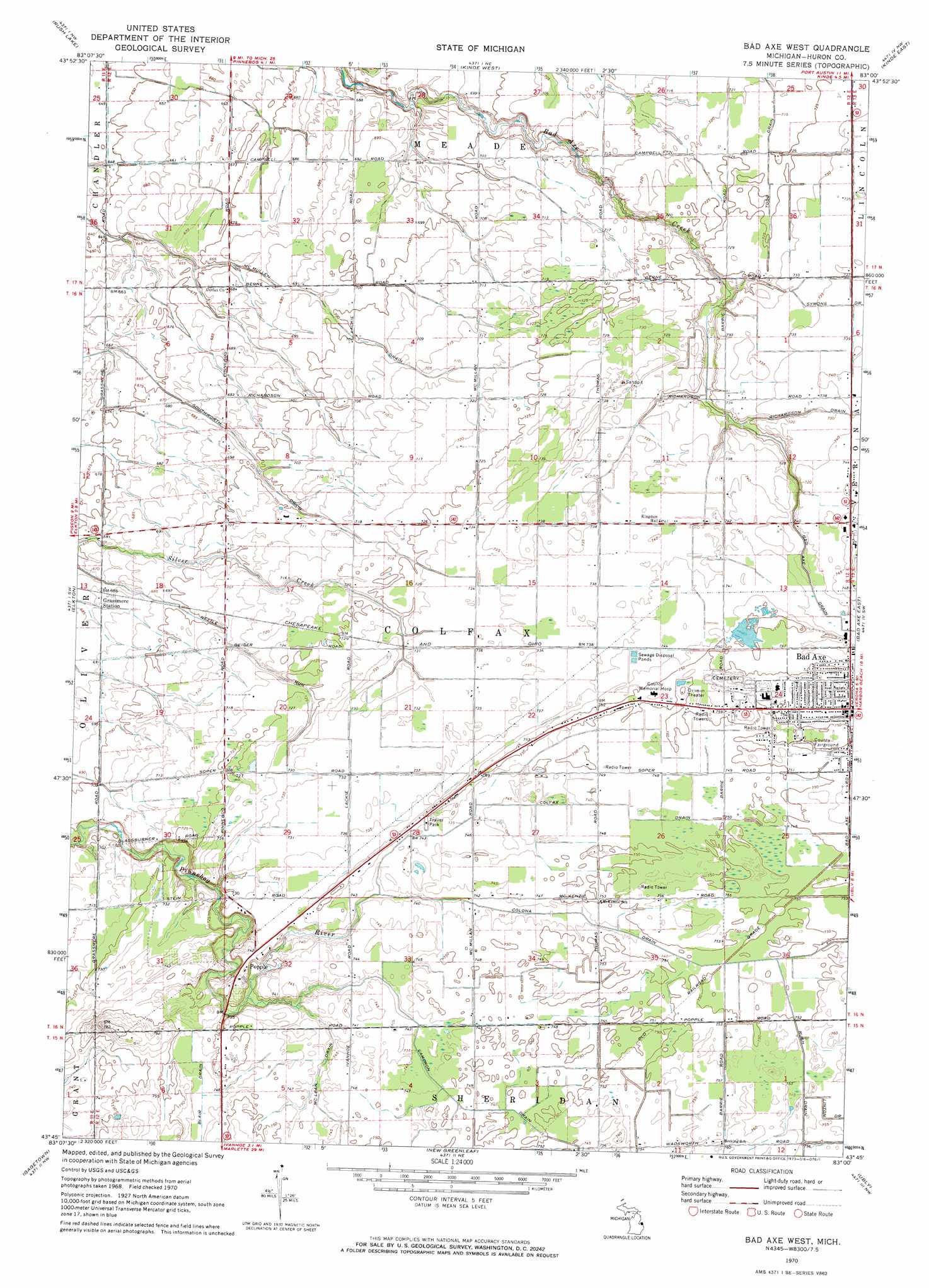
Bad Axe West Topo Map Michigan
To zoom in, hover over the map of Bad Axe West
USGS Topo Quad 43083g1 - 1:24,000 scale
| Topo Map Name: | Bad Axe West |
| USGS Topo Quad ID: | 43083g1 |
| Print Size: | ca. 21 1/4" wide x 27" high |
| Southeast Coordinates: | 43.75° N latitude / 83° W longitude |
| Map Center Coordinates: | 43.8125° N latitude / 83.0625° W longitude |
| U.S. State: | MI |
| Filename: | o43083g1.jpg |
| Download Map JPG Image: | Bad Axe West topo map 1:24,000 scale |
| Map Type: | Topographic |
| Topo Series: | 7.5´ |
| Map Scale: | 1:24,000 |
| Source of Map Images: | United States Geological Survey (USGS) |
| Alternate Map Versions: |
Bad Axe West MI 1970, updated 1973 Download PDF Buy paper map Bad Axe West MI 2011 Download PDF Buy paper map Bad Axe West MI 2014 Download PDF Buy paper map Bad Axe West MI 2017 Download PDF Buy paper map |
1:24,000 Topo Quads surrounding Bad Axe West
Port Austin West |
Port Austin East |
Huron City |
||
Caseville |
Rush Lake |
Kinde West |
Kinde East |
Redman |
Bay Port East |
Elkton |
Bad Axe West |
Bad Axe East |
Bad Axe Se |
Owendale |
Gagetown |
New Greenleaf |
Ubly |
Minden City |
Ellington |
Cass City |
Shabbona |
Argyle |
Palms |
> Back to 43083e1 at 1:100,000 scale
> Back to 43082a1 at 1:250,000 scale
> Back to U.S. Topo Maps home
Bad Axe West topo map: Gazetteer
Bad Axe West: Canals
Bad Axe Drain elevation 225m 738′Cameron Drain elevation 227m 744′
Colfax Drain elevation 227m 744′
Colona Drain elevation 227m 744′
McLean Drain elevation 226m 741′
McMullen Drain elevation 210m 688′
Southworth Drain elevation 204m 669′
Bad Axe West: Populated Places
Bad Axe elevation 231m 757′Lyndon Mobile Home Court elevation 225m 738′
Misty Meadows Mobile Home Park elevation 227m 744′
Pines Mobile Home Village elevation 230m 754′
Popple elevation 226m 741′
Bad Axe West: Post Offices
Grassmere Post Office (historical) elevation 209m 685′Popple Post Office (historical) elevation 226m 741′
Bad Axe West digital topo map on disk
Buy this Bad Axe West topo map showing relief, roads, GPS coordinates and other geographical features, as a high-resolution digital map file on DVD:
 map DVD")