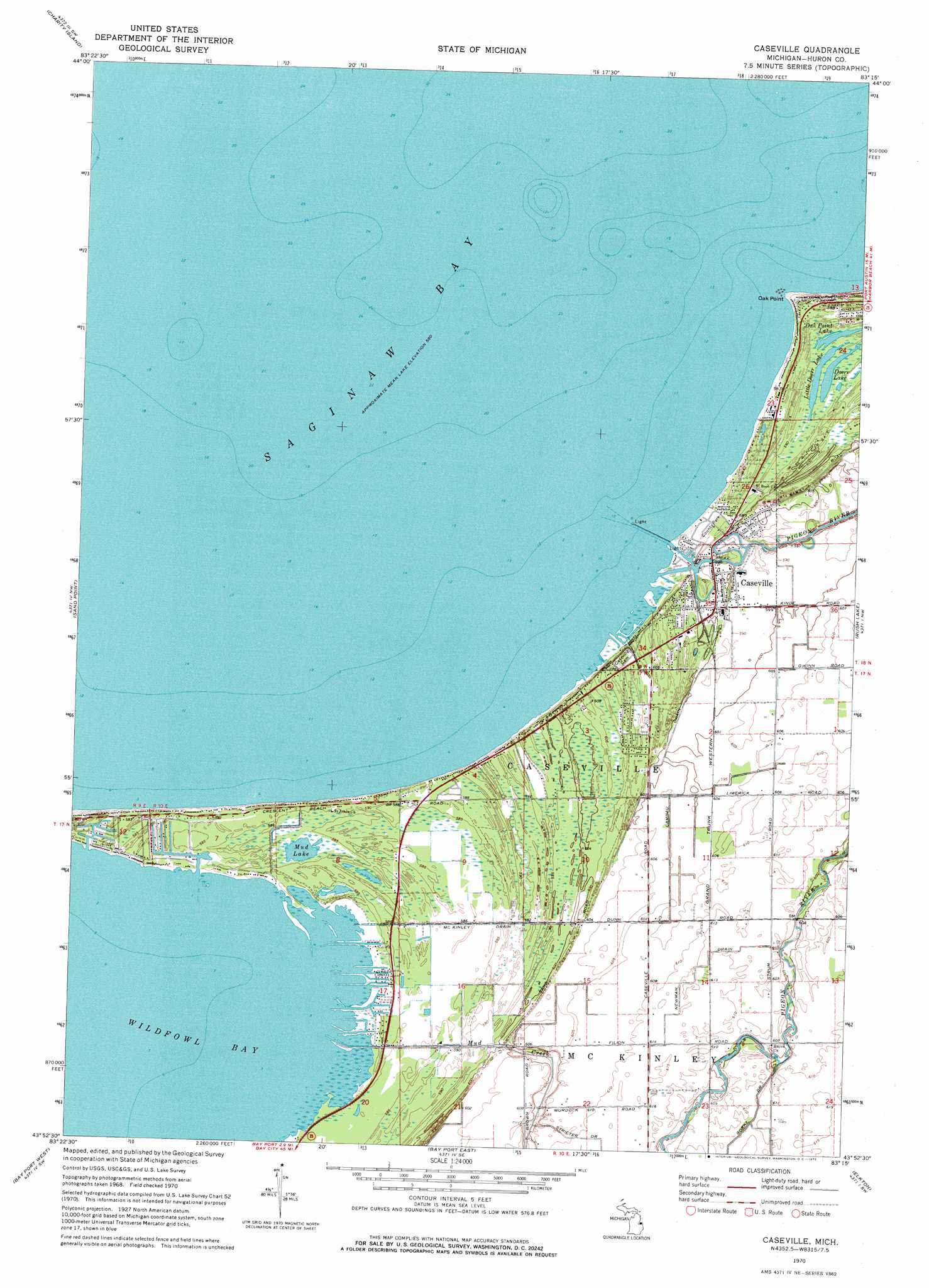
Caseville Topo Map Michigan
To zoom in, hover over the map of Caseville
USGS Topo Quad 43083h3 - 1:24,000 scale
| Topo Map Name: | Caseville |
| USGS Topo Quad ID: | 43083h3 |
| Print Size: | ca. 21 1/4" wide x 27" high |
| Southeast Coordinates: | 43.875° N latitude / 83.25° W longitude |
| Map Center Coordinates: | 43.9375° N latitude / 83.3125° W longitude |
| U.S. State: | MI |
| Filename: | o43083h3.jpg |
| Download Map JPG Image: | Caseville topo map 1:24,000 scale |
| Map Type: | Topographic |
| Topo Series: | 7.5´ |
| Map Scale: | 1:24,000 |
| Source of Map Images: | United States Geological Survey (USGS) |
| Alternate Map Versions: |
Caseville MI 1970, updated 1972 Download PDF Buy paper map Caseville MI 2011 Download PDF Buy paper map Caseville MI 2014 Download PDF Buy paper map Caseville MI 2016 Download PDF Buy paper map |
1:24,000 Topo Quads surrounding Caseville
Alabaster |
||||
Point Lookout |
Charity Island |
Port Austin West |
||
Sand Point |
Caseville |
Rush Lake |
Kinde West |
|
Bay Port West |
Bay Port East |
Elkton |
Bad Axe West |
|
Fish Point |
Sebewaing |
Owendale |
Gagetown |
New Greenleaf |
> Back to 43083e1 at 1:100,000 scale
> Back to 43082a1 at 1:250,000 scale
> Back to U.S. Topo Maps home
Caseville topo map: Gazetteer
Caseville: Airports
Farver Field elevation 183m 600′Caseville: Bays
Wild Fowl Bay elevation 177m 580′Caseville: Canals
Campau Drain elevation 182m 597′McKinley Drain elevation 178m 583′
Newman Drain elevation 185m 606′
Caseville: Capes
Oak Point elevation 179m 587′Caseville: Lakes
Doerr Lake elevation 179m 587′Little Doerr Lake elevation 179m 587′
Mud Lake elevation 177m 580′
Oak Point Lake elevation 179m 587′
Caseville: Parks
Caseville County Park elevation 180m 590′Huron County Park elevation 179m 587′
Methodist Episcopal Church Historical Marker elevation 180m 590′
Caseville: Populated Places
Caseville elevation 183m 600′Caseville: Post Offices
Caseville Post Office elevation 184m 603′Hayes Post Office (historical) elevation 184m 603′
Caseville: Streams
Mud Creek elevation 177m 580′Pigeon River elevation 178m 583′
Caseville digital topo map on disk
Buy this Caseville topo map showing relief, roads, GPS coordinates and other geographical features, as a high-resolution digital map file on DVD:
 map DVD")