Saint Charles Topo Map Michigan
To zoom in, hover over the map of Saint Charles
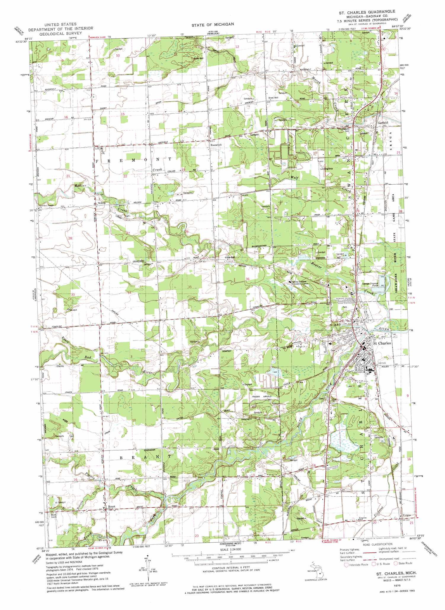
USGS Topo Quad 43084c2 - 1:24,000 scale
| Topo Map Name: | Saint Charles |
| USGS Topo Quad ID: | 43084c2 |
| Print Size: | ca. 21 1/4" wide x 27" high |
| Southeast Coordinates: | 43.25° N latitude / 84.125° W longitude |
| Map Center Coordinates: | 43.3125° N latitude / 84.1875° W longitude |
| U.S. State: | MI |
| Filename: | o43084c2.jpg |
| Download Map JPG Image: | Saint Charles topo map 1:24,000 scale |
| Map Type: | Topographic |
| Topo Series: | 7.5´ |
| Map Scale: | 1:24,000 |
| Source of Map Images: | United States Geological Survey (USGS) |
| Alternate Map Versions: |
Saint Charles MI 2011 Download PDF Buy paper map Saint Charles MI 2014 Download PDF Buy paper map Saint Charles MI 2016 Download PDF Buy paper map |
1:24,000 Topo Quads surrounding Saint Charles
Floyd |
Gordonville |
Midland South |
Auburn |
Bay City |
Breckenridge |
Merrill |
Hemlock |
Shields |
Saginaw |
Rathbone |
Lakefield |
Saint Charles |
Alicia |
Bridgeport |
Ashley |
Chapin |
Chesaning West |
Chesaning East |
Montrose |
Ovid West |
Ovid East |
Owosso North |
Easton |
New Lothrop |
> Back to 43084a1 at 1:100,000 scale
> Back to 43084a1 at 1:250,000 scale
> Back to U.S. Topo Maps home
Saint Charles topo map: Gazetteer
Saint Charles: Canals
Dygert Drain elevation 183m 600′Short Ditch elevation 189m 620′
Webb Drain elevation 189m 620′
Saint Charles: Parks
Coal Mine Number Eight Historical Marker elevation 0m 0′Fowler Schoolhouse Historical Marker elevation 0m 0′
Hartley Outdoor Recreation Center elevation 188m 616′
Lumberjack Park elevation 180m 590′
Saginaw Valley Coal Historical Marker elevation 0m 0′
Saint Charles Waterfowl Observatory elevation 180m 590′
Schroeder House Historical Marker elevation 0m 0′
Swan Creek Township Park elevation 182m 597′
Village Park elevation 184m 603′
Saint Charles: Populated Places
Brant elevation 187m 613′Garfield elevation 183m 600′
Nelson elevation 190m 623′
Roosevelt elevation 187m 613′
Saint Charles elevation 182m 597′
Saint Charles: Post Offices
Brant Post Office elevation 0m 0′Eastwood Post Office (historical) elevation 180m 590′
Fergus Post Office (historical) elevation 183m 600′
Nelson Post Office (historical) elevation 191m 626′
Orr Post Office (historical) elevation 183m 600′
Roosevelt Post Office (historical) elevation 187m 613′
Saint Charles Post Office elevation 181m 593′
Saint Charles: Streams
Beaver Creek elevation 178m 583′Blackmer Drain elevation 178m 583′
Eagle Creek elevation 184m 603′
Eaton Drain elevation 178m 583′
Little Potato Creek elevation 183m 600′
Potato Creek elevation 181m 593′
South Fork Bad River elevation 178m 583′
Saint Charles digital topo map on disk
Buy this Saint Charles topo map showing relief, roads, GPS coordinates and other geographical features, as a high-resolution digital map file on DVD: