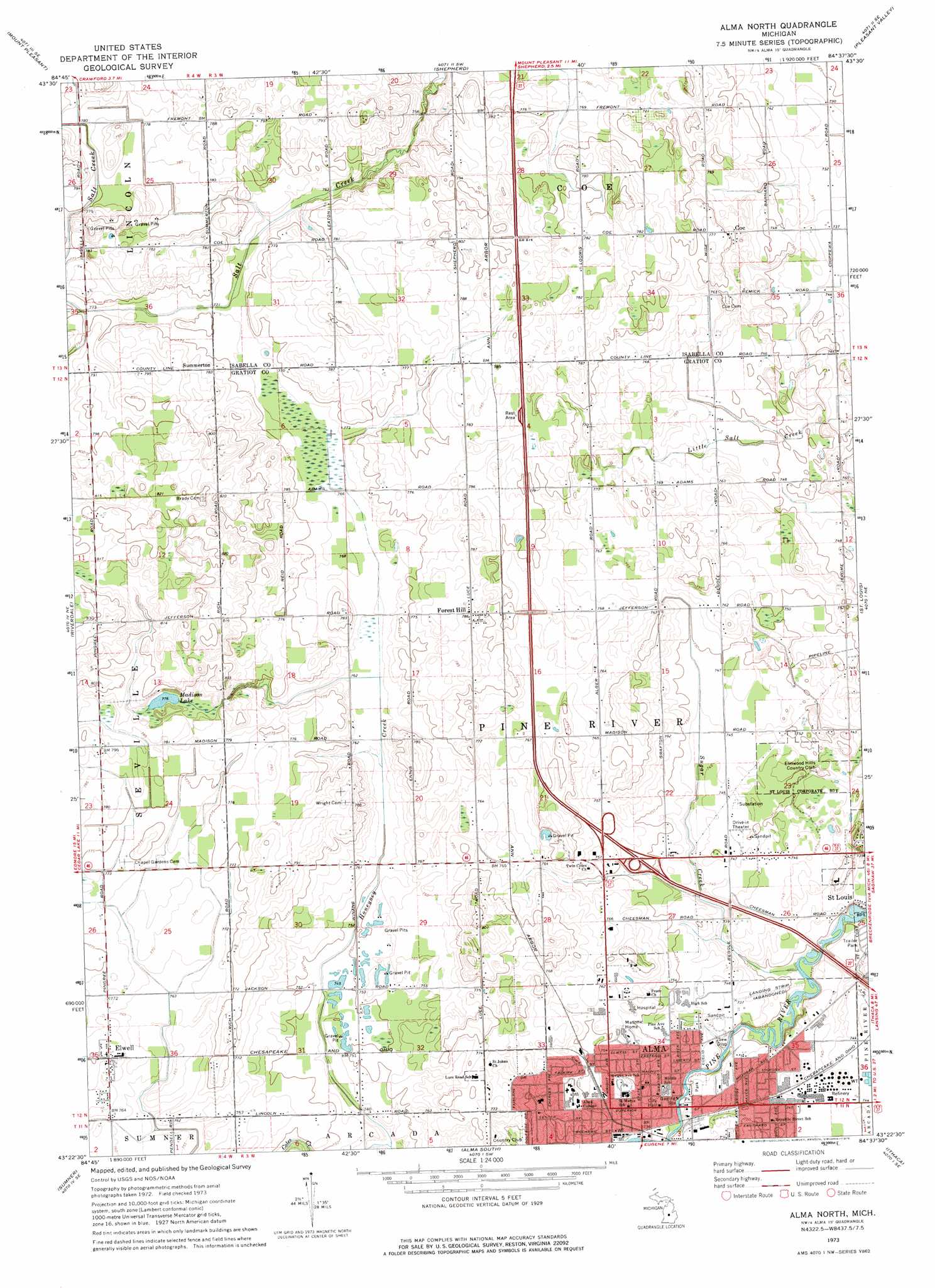
Alma North Topo Map Michigan
To zoom in, hover over the map of Alma North
USGS Topo Quad 43084d6 - 1:24,000 scale
| Topo Map Name: | Alma North |
| USGS Topo Quad ID: | 43084d6 |
| Print Size: | ca. 21 1/4" wide x 27" high |
| Southeast Coordinates: | 43.375° N latitude / 84.625° W longitude |
| Map Center Coordinates: | 43.4375° N latitude / 84.6875° W longitude |
| U.S. State: | MI |
| Filename: | o43084d6.jpg |
| Download Map JPG Image: | Alma North topo map 1:24,000 scale |
| Map Type: | Topographic |
| Topo Series: | 7.5´ |
| Map Scale: | 1:24,000 |
| Source of Map Images: | United States Geological Survey (USGS) |
| Alternate Map Versions: |
Alma North MI 1973, updated 1976 Download PDF Buy paper map Alma North MI 2011 Download PDF Buy paper map Alma North MI 2014 Download PDF Buy paper map Alma North MI 2016 Download PDF Buy paper map |
1:24,000 Topo Quads surrounding Alma North
Weidman |
Rosebush |
Leaton |
Alamando |
Sanford |
Winn |
Mount Pleasant |
Shepherd |
Pleasant Valley |
Floyd |
Vestaburg |
Riverdale |
Alma North |
Saint Louis |
Breckenridge |
Crystal |
Sumner |
Alma South |
Ithaca |
Rathbone |
Butternut |
Carson City |
Perrinton |
Pompeii |
Ashley |
> Back to 43084a1 at 1:100,000 scale
> Back to 43084a1 at 1:250,000 scale
> Back to U.S. Topo Maps home
Alma North topo map: Gazetteer
Alma North: Crossings
Interchange 127 elevation 233m 764′Alma North: Lakes
Madison Lake elevation 236m 774′Alma North: Parks
Alma College Historical Marker elevation 230m 754′Michigan Masonic Home Historical Marker elevation 232m 761′
Wright Park elevation 0m 0′
Alma North: Populated Places
Alma elevation 224m 734′Coe elevation 232m 761′
Elwell elevation 235m 770′
Forest Hill elevation 239m 784′
Scotsdale Estates Mobile Home Park elevation 0m 0′
Summerton elevation 238m 780′
Alma North: Post Offices
Alma Post Office elevation 224m 734′Cahoon Post Office (historical) elevation 239m 784′
Coe Post Office (historical) elevation 232m 761′
Elwell Post Office elevation 235m 770′
Forest Hill Post Office (historical) elevation 239m 784′
Parkinson Post Office (historical) elevation 239m 784′
Summerton Post Office (historical) elevation 234m 767′
Alma North: Streams
Coles Creek elevation 224m 734′Sugar Creek elevation 219m 718′
Alma North digital topo map on disk
Buy this Alma North topo map showing relief, roads, GPS coordinates and other geographical features, as a high-resolution digital map file on DVD: