Riverdale Topo Map Michigan
To zoom in, hover over the map of Riverdale
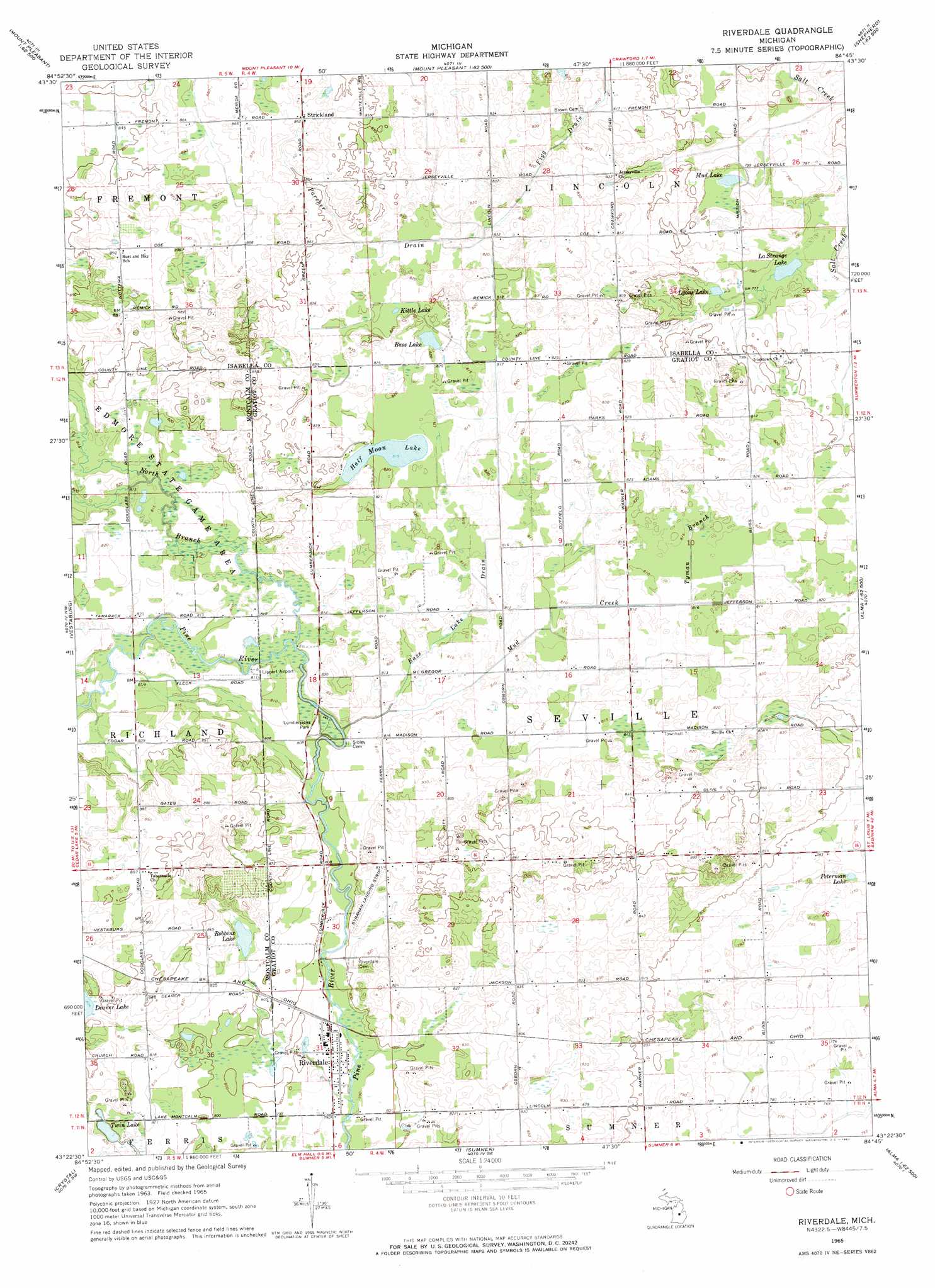
USGS Topo Quad 43084d7 - 1:24,000 scale
| Topo Map Name: | Riverdale |
| USGS Topo Quad ID: | 43084d7 |
| Print Size: | ca. 21 1/4" wide x 27" high |
| Southeast Coordinates: | 43.375° N latitude / 84.75° W longitude |
| Map Center Coordinates: | 43.4375° N latitude / 84.8125° W longitude |
| U.S. State: | MI |
| Filename: | o43084d7.jpg |
| Download Map JPG Image: | Riverdale topo map 1:24,000 scale |
| Map Type: | Topographic |
| Topo Series: | 7.5´ |
| Map Scale: | 1:24,000 |
| Source of Map Images: | United States Geological Survey (USGS) |
| Alternate Map Versions: |
Riverdale MI 1965, updated 1967 Download PDF Buy paper map Riverdale MI 2011 Download PDF Buy paper map Riverdale MI 2014 Download PDF Buy paper map Riverdale MI 2016 Download PDF Buy paper map |
1:24,000 Topo Quads surrounding Riverdale
Sherman City |
Weidman |
Rosebush |
Leaton |
Alamando |
Blanchard |
Winn |
Mount Pleasant |
Shepherd |
Pleasant Valley |
Edmore |
Vestaburg |
Riverdale |
Alma North |
Saint Louis |
Stanton |
Crystal |
Sumner |
Alma South |
Ithaca |
Sheridan |
Butternut |
Carson City |
Perrinton |
Pompeii |
> Back to 43084a1 at 1:100,000 scale
> Back to 43084a1 at 1:250,000 scale
> Back to U.S. Topo Maps home
Riverdale topo map: Gazetteer
Riverdale: Airports
Hamp Airport elevation 250m 820′Riverdale: Canals
Bass Lake Drain elevation 247m 810′Riverdale: Lakes
Bass Lake elevation 249m 816′Half Moon Lake elevation 248m 813′
Kittle Lake elevation 250m 820′
LaStrange Lake elevation 235m 770′
Lyons Lake elevation 237m 777′
Mud Lake elevation 238m 780′
Peterman Lake elevation 234m 767′
Robbins Lake elevation 245m 803′
Twin Lake elevation 242m 793′
Riverdale: Parks
Lumberjack Park elevation 245m 803′Lumberjack Park Historical Marker elevation 245m 803′
Riverdale: Populated Places
Riverdale elevation 242m 793′Strickland elevation 263m 862′
Timber Country Mobile Home Park elevation 248m 813′
Riverdale: Post Offices
Beaver Creek Post Office (historical) elevation 247m 810′Jerseyville Post Office (historical) elevation 246m 807′
Riverdale Post Office elevation 242m 793′
Strickland Post Office (historical) elevation 263m 862′
Riverdale: Streams
Mud Creek elevation 244m 800′North Branch Pine River elevation 247m 810′
Parcher Drain elevation 252m 826′
Tyman Branch elevation 247m 810′
Riverdale digital topo map on disk
Buy this Riverdale topo map showing relief, roads, GPS coordinates and other geographical features, as a high-resolution digital map file on DVD: