Auburn Topo Map Michigan
To zoom in, hover over the map of Auburn
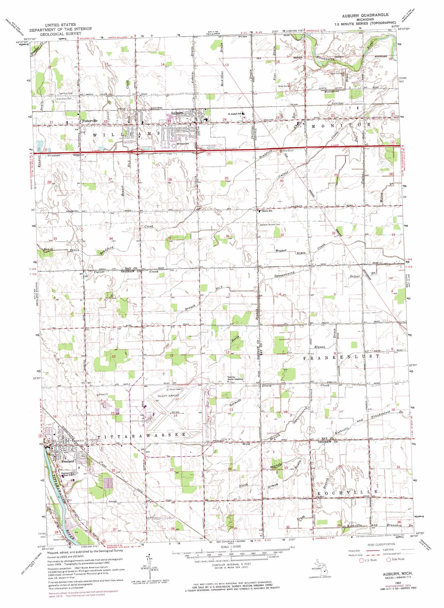
USGS Topo Quad 43084e1 - 1:24,000 scale
| Topo Map Name: | Auburn |
| USGS Topo Quad ID: | 43084e1 |
| Print Size: | ca. 21 1/4" wide x 27" high |
| Southeast Coordinates: | 43.5° N latitude / 84° W longitude |
| Map Center Coordinates: | 43.5625° N latitude / 84.0625° W longitude |
| U.S. State: | MI |
| Filename: | o43084e1.jpg |
| Download Map JPG Image: | Auburn topo map 1:24,000 scale |
| Map Type: | Topographic |
| Topo Series: | 7.5´ |
| Map Scale: | 1:24,000 |
| Source of Map Images: | United States Geological Survey (USGS) |
| Alternate Map Versions: |
Auburn MI 1962, updated 1964 Download PDF Buy paper map Auburn MI 1962, updated 1974 Download PDF Buy paper map Auburn MI 2011 Download PDF Buy paper map Auburn MI 2014 Download PDF Buy paper map Auburn MI 2017 Download PDF Buy paper map |
1:24,000 Topo Quads surrounding Auburn
Hope |
Estey |
Crump |
Pinconning |
|
Averill |
Midland North |
Willard |
Kawkawlin |
Bay City Ne |
Gordonville |
Midland South |
Auburn |
Bay City |
Essexville |
Merrill |
Hemlock |
Shields |
Saginaw |
Saginaw Ne |
Lakefield |
Saint Charles |
Alicia |
Bridgeport |
Birch Run North |
> Back to 43084e1 at 1:100,000 scale
> Back to 43084a1 at 1:250,000 scale
> Back to U.S. Topo Maps home
Auburn topo map: Gazetteer
Auburn: Airports
Tri City International Airport elevation 202m 662′Auburn: Canals
Auburn Drain elevation 186m 610′Beiser Drain elevation 184m 603′
Branch Number Five elevation 192m 629′
Foster Drain elevation 183m 600′
Klauss Drain elevation 185m 606′
Kochville and Branches Drain elevation 188m 616′
McArthur Drain elevation 185m 606′
Phillips Drain elevation 184m 603′
Pine Drain elevation 184m 603′
Schmidt Drain elevation 192m 629′
Wagner Drain elevation 187m 613′
Wilcox Drain elevation 183m 600′
Wolverine Drain elevation 182m 597′
Auburn: Parks
Auburn Park elevation 187m 613′Freeland United Methodist Church Historical Marker elevation 0m 0′
Little League Field elevation 190m 623′
Memorial Park elevation 184m 603′
Pine Grove Cemetery Historical Marker elevation 195m 639′
Village Park elevation 189m 620′
Auburn: Populated Places
Auburn elevation 188m 616′Fairfield Manor Mobile Home Park elevation 184m 603′
Falconview Estates Mobile Home Park elevation 202m 662′
Fisherville elevation 194m 636′
Freeland elevation 189m 620′
Auburn: Post Offices
Auburn Post Office elevation 191m 626′Freeland Post Office elevation 190m 623′
Laredo Post Office (historical) elevation 194m 636′
Tittabawassee Post Office (historical) elevation 189m 620′
Auburn: Streams
Armon Drain elevation 190m 623′Bench Drain elevation 197m 646′
Bradford Creek elevation 180m 590′
Branch Number Three Squaconning Creek elevation 189m 620′
Kindell Drain elevation 190m 623′
North Branch Kochville and Frankenlust Drain elevation 189m 620′
North Branch Squaconning Creek elevation 189m 620′
South Branch Kochville and Frankenlust Drain elevation 189m 620′
West Branch Squaconning Creek elevation 187m 613′
Auburn digital topo map on disk
Buy this Auburn topo map showing relief, roads, GPS coordinates and other geographical features, as a high-resolution digital map file on DVD: