Loomis Topo Map Michigan
To zoom in, hover over the map of Loomis
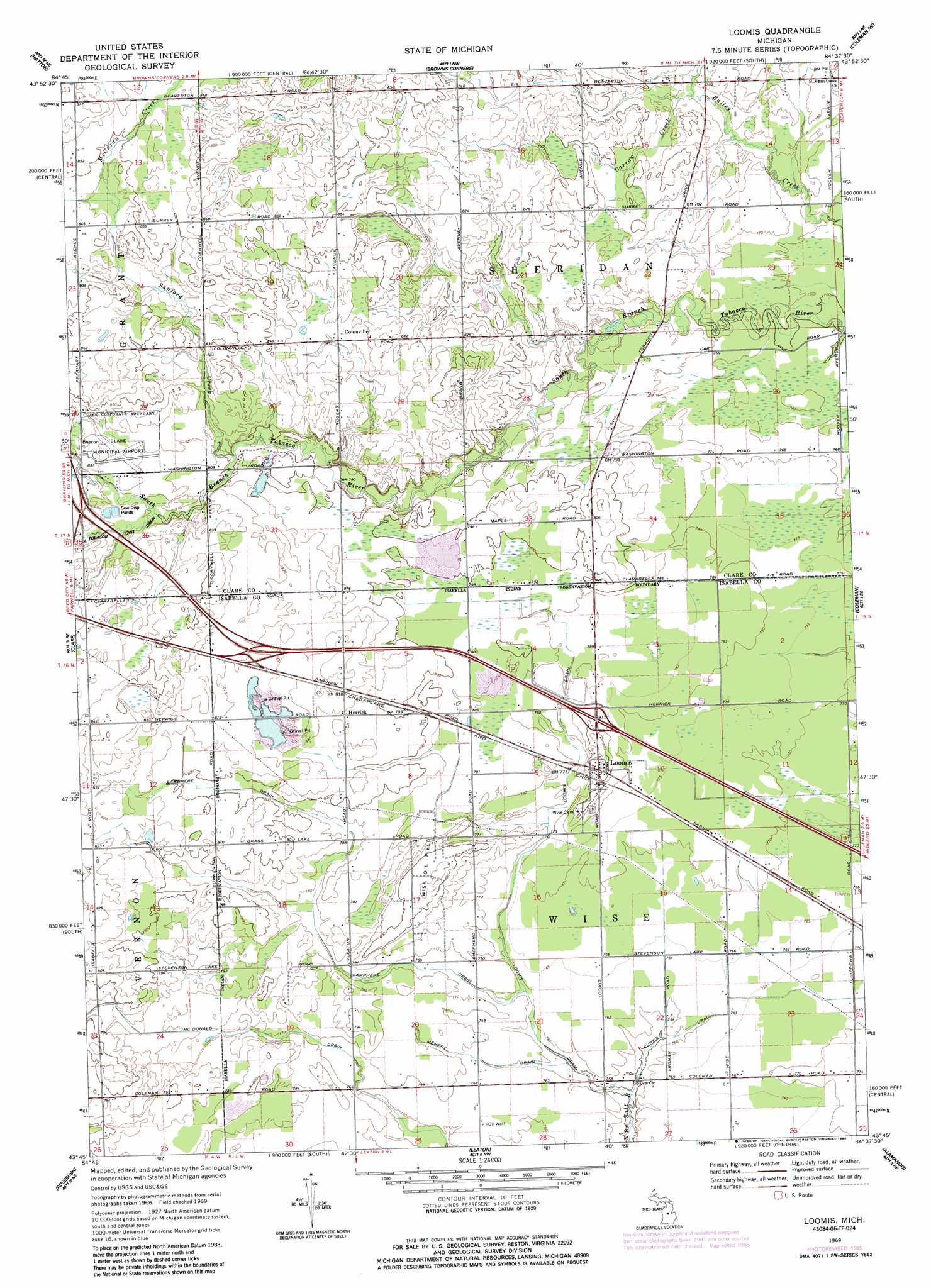
USGS Topo Quad 43084g6 - 1:24,000 scale
| Topo Map Name: | Loomis |
| USGS Topo Quad ID: | 43084g6 |
| Print Size: | ca. 21 1/4" wide x 27" high |
| Southeast Coordinates: | 43.75° N latitude / 84.625° W longitude |
| Map Center Coordinates: | 43.8125° N latitude / 84.6875° W longitude |
| U.S. State: | MI |
| Filename: | o43084g6.jpg |
| Download Map JPG Image: | Loomis topo map 1:24,000 scale |
| Map Type: | Topographic |
| Topo Series: | 7.5´ |
| Map Scale: | 1:24,000 |
| Source of Map Images: | United States Geological Survey (USGS) |
| Alternate Map Versions: |
Loomis MI 1969, updated 1972 Download PDF Buy paper map Loomis MI 1969, updated 1985 Download PDF Buy paper map Loomis MI 2011 Download PDF Buy paper map Loomis MI 2014 Download PDF Buy paper map Loomis MI 2017 Download PDF Buy paper map |
1:24,000 Topo Quads surrounding Loomis
Prestle Creek |
Harrison |
Meredith Sw |
Skeels |
Wagarville |
Lake George |
Hatton |
Browns Corners |
Coleman Ne |
Gladwin |
Woods |
Clare |
Loomis |
Coleman |
Edenville |
Weidman |
Rosebush |
Leaton |
Alamando |
Sanford |
Winn |
Mount Pleasant |
Shepherd |
Pleasant Valley |
Floyd |
> Back to 43084e1 at 1:100,000 scale
> Back to 43084a1 at 1:250,000 scale
> Back to U.S. Topo Maps home
Loomis topo map: Gazetteer
Loomis: Airports
Clare Municipal Airport elevation 251m 823′Loomis: Canals
Lamphere Drain elevation 231m 757′Loomis Drain elevation 228m 748′
McDonald Drain elevation 233m 764′
Loomis: Lakes
Shively Lake elevation 244m 800′Loomis: Oilfields
Wise Oil Field elevation 235m 770′Loomis: Parks
Herrick Recreation Area elevation 247m 810′Michigan's Petroleum Industry Historical Marker elevation 249m 816′
Loomis: Populated Places
Colonville elevation 253m 830′Herrick elevation 246m 807′
Loomis elevation 247m 810′
Loomis: Post Offices
Colonville Post Office (historical) elevation 253m 830′Herrick Post Office (historical) elevation 246m 807′
Loomis Post Office (historical) elevation 247m 810′
Loomis: Streams
Carrow Creek elevation 237m 777′Curtis Drain elevation 228m 748′
McCuran Creek elevation 255m 836′
Menery Drain elevation 229m 751′
Sanford Creek elevation 243m 797′
Loomis digital topo map on disk
Buy this Loomis topo map showing relief, roads, GPS coordinates and other geographical features, as a high-resolution digital map file on DVD: