Lake George Topo Map Michigan
To zoom in, hover over the map of Lake George
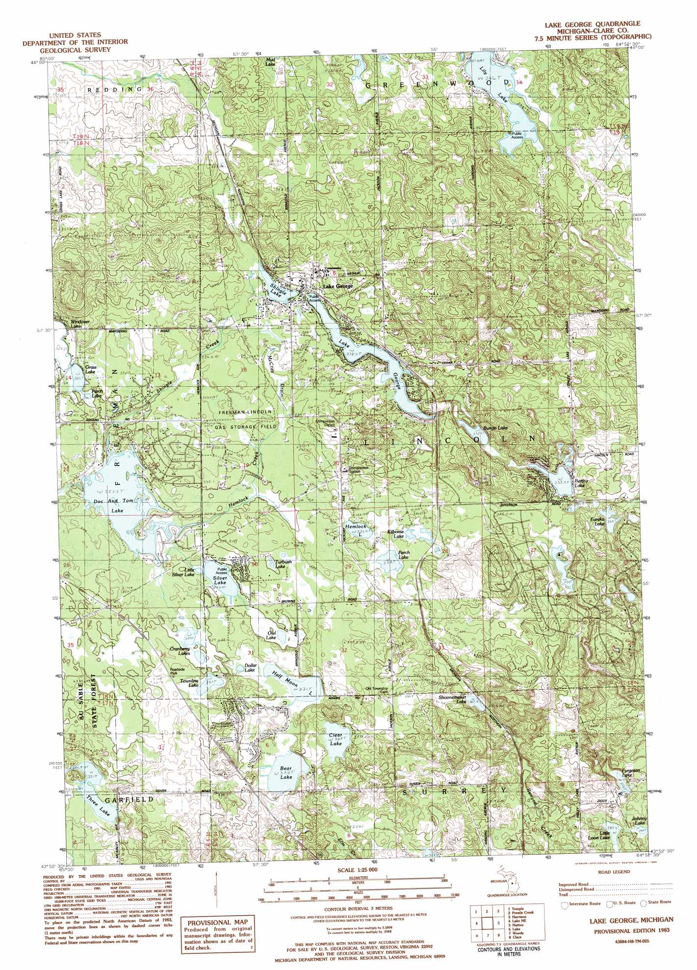
USGS Topo Quad 43084h8 - 1:25,000 scale
| Topo Map Name: | Lake George |
| USGS Topo Quad ID: | 43084h8 |
| Print Size: | ca. 21 1/4" wide x 27" high |
| Southeast Coordinates: | 43.875° N latitude / 84.875° W longitude |
| Map Center Coordinates: | 43.9375° N latitude / 84.9375° W longitude |
| U.S. State: | MI |
| Filename: | l43084h8.jpg |
| Download Map JPG Image: | Lake George topo map 1:25,000 scale |
| Map Type: | Topographic |
| Topo Series: | 7.5´ |
| Map Scale: | 1:25,000 |
| Source of Map Images: | United States Geological Survey (USGS) |
| Alternate Map Versions: |
Lake George MI 1983, updated 1984 Download PDF Buy paper map |
1:24,000 Topo Quads surrounding Lake George
Mcbain |
Falmouth |
Moddersville |
Cooperton |
Meredith Nw |
Marion |
Temple |
Prestle Creek |
Harrison |
Meredith Sw |
Sears |
Lake Ne |
Lake George |
Hatton |
Browns Corners |
Merrill Lake |
Lake |
Woods |
Clare |
Loomis |
Mecosta Nw |
Sherman City |
Weidman |
Rosebush |
Leaton |
> Back to 43084e1 at 1:100,000 scale
> Back to 43084a1 at 1:250,000 scale
> Back to U.S. Topo Maps home
Lake George topo map: Gazetteer
Lake George: Lakes
Bear Lake elevation 335m 1099′Bertha Lake elevation 332m 1089′
Bungo Lake elevation 335m 1099′
Clear Lake elevation 334m 1095′
Cranberry Lakes elevation 329m 1079′
Doc and Tom Lake elevation 323m 1059′
Dollar Lake elevation 333m 1092′
Eureka Lake elevation 327m 1072′
Furgeson Lake elevation 295m 967′
Grass Lake elevation 329m 1079′
Half Moon Lake elevation 331m 1085′
Hemlock Lake elevation 332m 1089′
Johnny Lake elevation 291m 954′
Kilborne Lake elevation 333m 1092′
Lake George elevation 338m 1108′
Lily Lake elevation 346m 1135′
Little Loon Lake elevation 287m 941′
Little Silver Lake elevation 327m 1072′
Owl Lake elevation 330m 1082′
Perch Lake elevation 332m 1089′
Perch Lake elevation 330m 1082′
Schoomaker Lake elevation 317m 1040′
Shingle Lake elevation 337m 1105′
Shoonemaker Lake elevation 317m 1040′
Silver Lake elevation 328m 1076′
Three Lake elevation 321m 1053′
Townline Lake elevation 331m 1085′
Turbush Lake elevation 330m 1082′
Windover Lake elevation 328m 1076′
Lake George: Parks
Shingle Lake Park elevation 339m 1112′Lake George: Populated Places
Lake George elevation 339m 1112′Phelps elevation 333m 1092′
Lake George: Post Offices
Lake George Post Office elevation 340m 1115′Lake George: Streams
Hemlock Creek elevation 323m 1059′Shingle Creek elevation 323m 1059′
Lake George digital topo map on disk
Buy this Lake George topo map showing relief, roads, GPS coordinates and other geographical features, as a high-resolution digital map file on DVD: