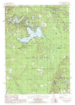
Big Star Lake Topo Map Michigan
To zoom in, hover over the map of Big Star Lake
USGS Topo Quad 43085g8 - 1:24,000 scale
| Topo Map Name: | Big Star Lake |
| USGS Topo Quad ID: | 43085g8 |
| Print Size: | ca. 21 1/4" wide x 27" high |
| Southeast Coordinates: | 43.75° N latitude / 85.875° W longitude |
| Map Center Coordinates: | 43.8125° N latitude / 85.9375° W longitude |
| U.S. State: | MI |
| Filename: | o43085g8.jpg |
| Download Map JPG Image: | Big Star Lake topo map 1:24,000 scale |
| Map Type: | Topographic |
| Topo Series: | 7.5´ |
| Map Scale: | 1:24,000 |
| Source of Map Images: | United States Geological Survey (USGS) |
| Alternate Map Versions: |
Big Star Lake MI 1987, updated 1987 Download PDF Buy paper map Big Star Lake MI 2012 Download PDF Buy paper map Big Star Lake MI 2014 Download PDF Buy paper map Big Star Lake MI 2017 Download PDF Buy paper map |
| FStopo: | US Forest Service topo Big Star Lake is available: Download FStopo PDF Download FStopo TIF |
1:24,000 Topo Quads surrounding Big Star Lake
> Back to 43085e1 at 1:100,000 scale
> Back to 43084a1 at 1:250,000 scale
> Back to U.S. Topo Maps home
Big Star Lake topo map: Gazetteer
Big Star Lake: Forests
Manistee National Forest elevation 268m 879′Big Star Lake: Lakes
Amaung Lake elevation 254m 833′Basford Lake elevation 251m 823′
Big Star Lake elevation 252m 826′
Bradford Lake elevation 242m 793′
Cecilia Lake elevation 251m 823′
Condon Lake elevation 257m 843′
Duck Lake elevation 252m 826′
Gifford Lake elevation 251m 823′
Highbank Lake elevation 265m 869′
Honeymoon Lake elevation 251m 823′
Jenks Lake elevation 241m 790′
Kenosha Lake elevation 245m 803′
Lamoreaux Lake elevation 267m 875′
Miller Lake elevation 252m 826′
Mud Lake elevation 239m 784′
Orchard Lake elevation 250m 820′
Otterman Lake elevation 240m 787′
Oxbow Lake elevation 248m 813′
Rainbow Lake elevation 250m 820′
Reed Lake elevation 250m 820′
Sawkaw Lake elevation 273m 895′
Shonenya Lake elevation 250m 820′
Big Star Lake: Populated Places
Pine Grove Beach elevation 255m 836′Big Star Lake: Reservoirs
Danaher Lake elevation 233m 764′Big Star Lake: Streams
Cedar Creek elevation 231m 757′Danaher Creek elevation 227m 744′
Freeman Creek elevation 230m 754′
Jenks Creek elevation 233m 764′
Triple Lakes Creek elevation 236m 774′
Big Star Lake: Swamps
Frog Marsh elevation 259m 849′Star Marsh elevation 254m 833′
Sterling Marsh elevation 247m 810′
Big Star Lake: Trails
Honeymoon Lake Snowmobile Trail elevation 257m 843′Big Star Lake digital topo map on disk
Buy this Big Star Lake topo map showing relief, roads, GPS coordinates and other geographical features, as a high-resolution digital map file on DVD:


