Baldwin Topo Map Michigan
To zoom in, hover over the map of Baldwin
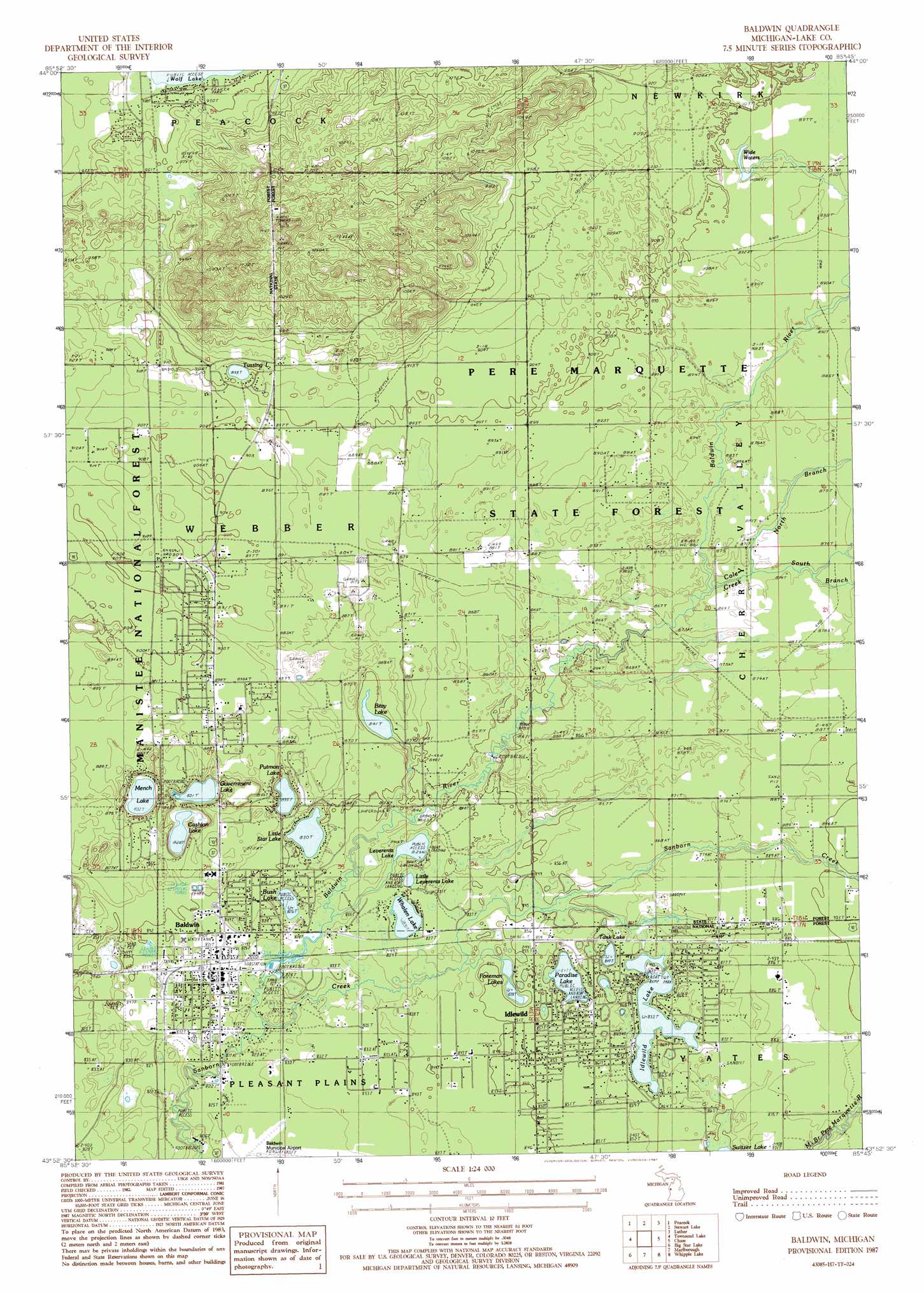
USGS Topo Quad 43085h7 - 1:24,000 scale
| Topo Map Name: | Baldwin |
| USGS Topo Quad ID: | 43085h7 |
| Print Size: | ca. 21 1/4" wide x 27" high |
| Southeast Coordinates: | 43.875° N latitude / 85.75° W longitude |
| Map Center Coordinates: | 43.9375° N latitude / 85.8125° W longitude |
| U.S. State: | MI |
| Filename: | o43085h7.jpg |
| Download Map JPG Image: | Baldwin topo map 1:24,000 scale |
| Map Type: | Topographic |
| Topo Series: | 7.5´ |
| Map Scale: | 1:24,000 |
| Source of Map Images: | United States Geological Survey (USGS) |
| Alternate Map Versions: |
Baldwin MI 1987, updated 1987 Download PDF Buy paper map Baldwin MI 2012 Download PDF Buy paper map Baldwin MI 2014 Download PDF Buy paper map Baldwin MI 2017 Download PDF Buy paper map |
| FStopo: | US Forest Service topo Baldwin is available: Download FStopo PDF Download FStopo TIF |
1:24,000 Topo Quads surrounding Baldwin
Freesoil Ne |
Peacock Nw |
Peacock Ne |
Luther Nw |
Luther Ne |
Freesoil Se |
Peacock Sw |
Peacock Se |
Luther Sw |
Luther Se |
Custer Ne |
Townsend Lake |
Baldwin |
Chase |
Reed City North |
Custer Se |
Big Star Lake |
Marlborough |
Whipple Lake |
Reed City South |
Walkerville East |
Walkup Lake |
Woodland Park |
Woodville |
Woodville Ne |
> Back to 43085e1 at 1:100,000 scale
> Back to 43084a1 at 1:250,000 scale
> Back to U.S. Topo Maps home
Baldwin topo map: Gazetteer
Baldwin: Airports
Baldwin Municipal Airport elevation 251m 823′Baldwin: Forests
Pere Marquette State Forest elevation 274m 898′Baldwin: Lakes
Bray Lake elevation 256m 839′Bush Lake elevation 252m 826′
Cashion Lake elevation 252m 826′
Foreman Lakes elevation 256m 839′
Government Lake elevation 253m 830′
Idlewild Lake elevation 260m 853′
Leverentz Lake elevation 253m 830′
Little Leverentz Lake elevation 254m 833′
Little Star Lake elevation 253m 830′
Mench Lake elevation 253m 830′
Paradise Lake elevation 258m 846′
Putman Lake elevation 254m 833′
Tank Lake elevation 259m 849′
Tussing Lake elevation 272m 892′
Whalen Lake elevation 253m 830′
Wide Waters elevation 271m 889′
Baldwin: Parks
Lake County Historical Marker elevation 255m 836′Baldwin: Populated Places
Baldwin elevation 256m 839′Idlewild elevation 260m 853′
Baldwin: Post Offices
Baldwin Post Office elevation 252m 826′Forman Post Office (historical) elevation 253m 830′
Idlewild Post Office elevation 260m 853′
Ungers Post Office (historical) elevation 272m 892′
Baldwin: Streams
Baldwin River elevation 249m 816′Bray Creek elevation 257m 843′
Cole Creek elevation 261m 856′
North Branch Cole Creek elevation 262m 859′
South Branch Cole Creek elevation 262m 859′
Baldwin: Swamps
Carpenter Marsh elevation 252m 826′Baldwin digital topo map on disk
Buy this Baldwin topo map showing relief, roads, GPS coordinates and other geographical features, as a high-resolution digital map file on DVD: