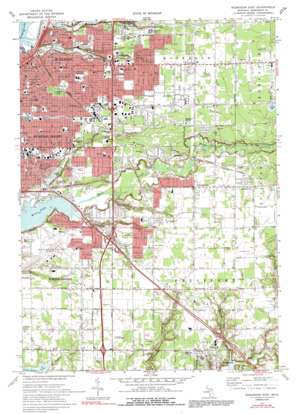
Muskegon East Topo Map Michigan
To zoom in, hover over the map of Muskegon East
USGS Topo Quad 43086b2 - 1:24,000 scale
| Topo Map Name: | Muskegon East |
| USGS Topo Quad ID: | 43086b2 |
| Print Size: | ca. 21 1/4" wide x 27" high |
| Southeast Coordinates: | 43.125° N latitude / 86.125° W longitude |
| Map Center Coordinates: | 43.1875° N latitude / 86.1875° W longitude |
| U.S. State: | MI |
| Filename: | o43086b2.jpg |
| Download Map JPG Image: | Muskegon East topo map 1:24,000 scale |
| Map Type: | Topographic |
| Topo Series: | 7.5´ |
| Map Scale: | 1:24,000 |
| Source of Map Images: | United States Geological Survey (USGS) |
| Alternate Map Versions: |
Muskegon East MI 1972, updated 1975 Download PDF Buy paper map Muskegon East MI 1972, updated 1991 Download PDF Buy paper map Muskegon East MI 2011 Download PDF Buy paper map Muskegon East MI 2014 Download PDF Buy paper map Muskegon East MI 2017 Download PDF Buy paper map |
1:24,000 Topo Quads surrounding Muskegon East
> Back to 43086a1 at 1:100,000 scale
> Back to 43086a1 at 1:250,000 scale
> Back to U.S. Topo Maps home
Muskegon East topo map: Gazetteer
Muskegon East: Airports
Hackley Hospital Emergency Heliport elevation 191m 626′Muskegon County Airport elevation 190m 623′
Muskegon General Hospital Heliport elevation 194m 636′
Muskegon East: Crossings
Interchange 1AB elevation 188m 616′Interchange 1C elevation 196m 643′
Interchange 4 elevation 192m 629′
Muskegon East: Guts
Sanford Bayou elevation 177m 580′Muskegon East: Parks
Aamodt Park elevation 191m 626′Beukema Park elevation 191m 626′
Evergreen Cemetery Historical Marker elevation 192m 629′
Fisherman's Landing Park elevation 179m 587′
Garst Playground elevation 190m 623′
Green Acres Park elevation 178m 583′
Harris Nature Park elevation 179m 587′
Hidden Cove Park elevation 177m 580′
Johnny O Haris Park elevation 182m 597′
Marsh Field elevation 191m 626′
Marsh Field Historical Marker elevation 191m 626′
McCrea Playground elevation 192m 629′
Mona Lake Park elevation 178m 583′
Muskegon Business College Historical Marker elevation 189m 620′
Parslow Park elevation 193m 633′
Pine Park elevation 192m 629′
Reese Playground elevation 194m 636′
Ross Lake Park elevation 189m 620′
Rowan City Park elevation 191m 626′
Sheldon Playground elevation 192m 629′
Smith Playground elevation 180m 590′
South Fruitport Township Park elevation 194m 636′
Muskegon East: Populated Places
Arlington Estates Mobile Village elevation 198m 649′Chauteau Norton Shores Mobile Home Park elevation 191m 626′
Clover Estates Mobile Home Park elevation 200m 656′
Cloverville elevation 195m 639′
Egelcraft Mobile Home Park elevation 199m 652′
Fruitport elevation 191m 626′
Hillcrest Mobile Home Park elevation 190m 623′
Mona Lake Mobile Home Park elevation 178m 583′
Muskegon elevation 188m 616′
Muskegon Heights elevation 190m 623′
Nomad Mobile Home Park elevation 191m 626′
Oaks Mobile Home Park elevation 190m 623′
Muskegon East: Post Offices
Black Lake Post Office (historical) elevation 188m 616′Fruitport Post Office elevation 189m 620′
Muskegon Heights Post Office elevation 192m 629′
Muskegon East: Streams
Black Creek elevation 177m 580′Little Black Creek elevation 177m 580′
Rhymer Creek elevation 187m 613′
Ryerson Creek elevation 177m 580′
South Channel elevation 177m 580′
Vincent Creek elevation 178m 583′
Willow Hill Creek elevation 183m 600′
Yonkers Drain elevation 183m 600′
Muskegon East digital topo map on disk
Buy this Muskegon East topo map showing relief, roads, GPS coordinates and other geographical features, as a high-resolution digital map file on DVD:


