Fox Lake Topo Map Wisconsin
To zoom in, hover over the map of Fox Lake
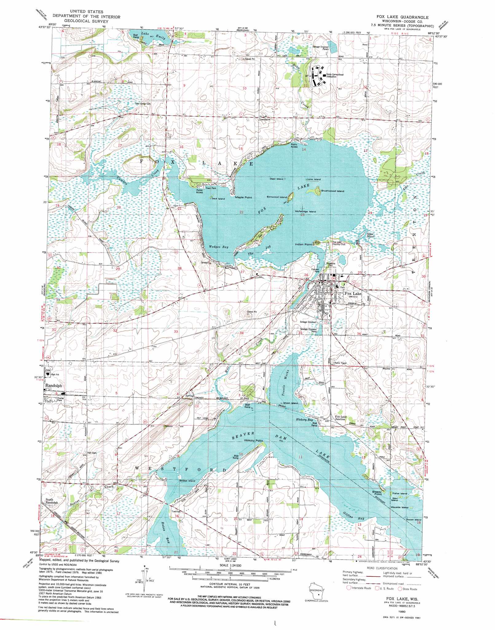
USGS Topo Quad 43088e8 - 1:24,000 scale
| Topo Map Name: | Fox Lake |
| USGS Topo Quad ID: | 43088e8 |
| Print Size: | ca. 21 1/4" wide x 27" high |
| Southeast Coordinates: | 43.5° N latitude / 88.875° W longitude |
| Map Center Coordinates: | 43.5625° N latitude / 88.9375° W longitude |
| U.S. State: | WI |
| Filename: | o43088e8.jpg |
| Download Map JPG Image: | Fox Lake topo map 1:24,000 scale |
| Map Type: | Topographic |
| Topo Series: | 7.5´ |
| Map Scale: | 1:24,000 |
| Source of Map Images: | United States Geological Survey (USGS) |
| Alternate Map Versions: |
Fox Lake WI 1980, updated 1981 Download PDF Buy paper map Fox Lake WI 2010 Download PDF Buy paper map Fox Lake WI 2013 Download PDF Buy paper map Fox Lake WI 2015 Download PDF Buy paper map |
1:24,000 Topo Quads surrounding Fox Lake
Princeton West |
Princeton East |
Green Lake |
Ripon |
Rosendale |
Marquette |
Manchester |
Markesan |
Brandon |
Waupun North |
Sand Spring Creek |
Randolph |
Fox Lake |
Buckhorn Corner |
Waupun South |
Rio |
Fall River |
Lost Lake |
Beaver Dam |
Horicon |
North Bristol |
Columbus |
Astigo |
Reeseville |
Clyman |
> Back to 43088e1 at 1:100,000 scale
> Back to 43088a1 at 1:250,000 scale
> Back to U.S. Topo Maps home
Fox Lake topo map: Gazetteer
Fox Lake: Airports
Beaver Dam Lake Seaplane Base elevation 265m 869′Fox Lake: Bays
Gilfins Bay elevation 265m 869′Hickory Bay elevation 265m 869′
Rakes Bay elevation 265m 869′
The Jug elevation 272m 892′
Trestle Works elevation 265m 869′
Wedges Bay elevation 272m 892′
Fox Lake: Capes
Breezy Point elevation 265m 869′Hickory Point elevation 268m 879′
Indian Point elevation 274m 898′
Maple Point elevation 276m 905′
Fox Lake: Dams
Fox Lake Dam elevation 271m 889′Fox Lake: Islands
Bedker Island elevation 265m 869′Brushwood Island elevation 277m 908′
Dead Island elevation 272m 892′
Devil Island elevation 272m 892′
Elmwood Island elevation 277m 908′
Fisher Island elevation 265m 869′
Goose Island elevation 265m 869′
Lone Island elevation 272m 892′
McFetridge Island elevation 272m 892′
Moon Island elevation 265m 869′
New Island elevation 265m 869′
Sager Island elevation 274m 898′
Wayside Island elevation 265m 869′
Fox Lake: Parks
Clausen Park elevation 274m 898′Firemans Park elevation 277m 908′
Jeanette Adams Municipal Swimming Pool elevation 276m 905′
Town Park elevation 274m 898′
Fox Lake: Populated Places
Delbern Acres elevation 273m 895′Fox Lake elevation 277m 908′
Fox Lake Junction elevation 271m 889′
Lyndon Dale elevation 275m 902′
South Randolph elevation 280m 918′
Fox Lake: Reservoirs
Fox Lake elevation 271m 889′Fox Lake 52 elevation 272m 892′
Fox Lake: Streams
Alto Creek elevation 272m 892′Beaver Creek elevation 267m 875′
Drew Creek elevation 272m 892′
Fox Lake digital topo map on disk
Buy this Fox Lake topo map showing relief, roads, GPS coordinates and other geographical features, as a high-resolution digital map file on DVD: