Durwards Glen Topo Map Wisconsin
To zoom in, hover over the map of Durwards Glen
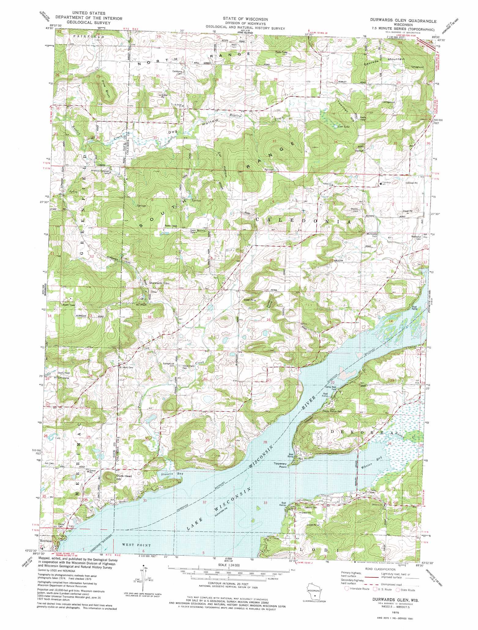
USGS Topo Quad 43089d5 - 1:24,000 scale
| Topo Map Name: | Durwards Glen |
| USGS Topo Quad ID: | 43089d5 |
| Print Size: | ca. 21 1/4" wide x 27" high |
| Southeast Coordinates: | 43.375° N latitude / 89.5° W longitude |
| Map Center Coordinates: | 43.4375° N latitude / 89.5625° W longitude |
| U.S. State: | WI |
| Filename: | o43089d5.jpg |
| Download Map JPG Image: | Durwards Glen topo map 1:24,000 scale |
| Map Type: | Topographic |
| Topo Series: | 7.5´ |
| Map Scale: | 1:24,000 |
| Source of Map Images: | United States Geological Survey (USGS) |
| Alternate Map Versions: |
Baraboo NE WI 1974, updated 1976 Download PDF Buy paper map Durwards Glen WI 1975, updated 1978 Download PDF Buy paper map Durwards Glen WI 2010 Download PDF Buy paper map Durwards Glen WI 2013 Download PDF Buy paper map Durwards Glen WI 2016 Download PDF Buy paper map |
1:24,000 Topo Quads surrounding Durwards Glen
Wisconsin Dells North |
Big Spring |
Briggsville |
Endeavor |
Observatory Hill |
Wisconsin Dells South |
Lewiston |
Pine Island |
Portage |
Pardeeville |
North Freedom |
Baraboo |
Durwards Glen |
Poynette |
Wyocena |
Sauk Prairie |
Sauk City |
Lodi |
Arlington |
Morrisonville |
Mazomanie |
Black Earth |
Springfield Corners |
Waunakee |
De Forest |
> Back to 43089a1 at 1:100,000 scale
> Back to 43088a1 at 1:250,000 scale
> Back to U.S. Topo Maps home
Durwards Glen topo map: Gazetteer
Durwards Glen: Bays
Stoners Bay elevation 236m 774′Whalen Bay elevation 236m 774′
Durwards Glen: Capes
Tipperary Point elevation 237m 777′Durwards Glen: Cliffs
Pine Bluff elevation 383m 1256′Durwards Glen: Lakes
Lost Lake elevation 323m 1059′Durwards Glen: Parks
Camp Rest Park elevation 240m 787′Happy Hollow Park elevation 243m 797′
Lost Lake State Natural Area elevation 322m 1056′
Owen Memorial Park elevation 429m 1407′
Durwards Glen: Populated Places
Durwards Glen elevation 314m 1030′Durwards Glen: Streams
Prentice Creek elevation 236m 774′Rowan Creek elevation 236m 774′
Durwards Glen: Summits
Cascade Mountain elevation 389m 1276′Owls Head Hill elevation 319m 1046′
Townhall Hill elevation 380m 1246′
Durwards Glen: Valleys
Cat Hollow elevation 290m 951′Dog Hollow elevation 266m 872′
Petras Ravine elevation 277m 908′
Durwards Glen digital topo map on disk
Buy this Durwards Glen topo map showing relief, roads, GPS coordinates and other geographical features, as a high-resolution digital map file on DVD: