Wisconsin Dells South Topo Map Wisconsin
To zoom in, hover over the map of Wisconsin Dells South
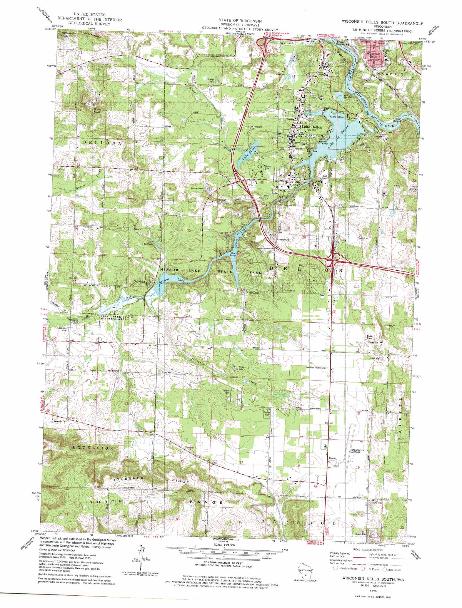
USGS Topo Quad 43089e7 - 1:24,000 scale
| Topo Map Name: | Wisconsin Dells South |
| USGS Topo Quad ID: | 43089e7 |
| Print Size: | ca. 21 1/4" wide x 27" high |
| Southeast Coordinates: | 43.5° N latitude / 89.75° W longitude |
| Map Center Coordinates: | 43.5625° N latitude / 89.8125° W longitude |
| U.S. State: | WI |
| Filename: | o43089e7.jpg |
| Download Map JPG Image: | Wisconsin Dells South topo map 1:24,000 scale |
| Map Type: | Topographic |
| Topo Series: | 7.5´ |
| Map Scale: | 1:24,000 |
| Source of Map Images: | United States Geological Survey (USGS) |
| Alternate Map Versions: |
Wisconsin Dells SE WI 1975, updated 1976 Download PDF Buy paper map Wisconsin Dells South WI 1975, updated 1978 Download PDF Buy paper map Wisconsin Dells South WI 1975, updated 1978 Download PDF Buy paper map Wisconsin Dells South WI 2010 Download PDF Buy paper map Wisconsin Dells South WI 2013 Download PDF Buy paper map Wisconsin Dells South WI 2016 Download PDF Buy paper map |
1:24,000 Topo Quads surrounding Wisconsin Dells South
Mauston |
Round Bluff |
Easton |
Brooks |
Oxford |
Potato Hill |
Lyndon Station |
Wisconsin Dells North |
Big Spring |
Briggsville |
Reedsburg West |
Reedsburg East |
Wisconsin Dells South |
Lewiston |
Pine Island |
Loganville |
Rock Springs |
North Freedom |
Baraboo |
Durwards Glen |
Plain |
Black Hawk |
Sauk Prairie |
Sauk City |
Lodi |
> Back to 43089e1 at 1:100,000 scale
> Back to 43088a1 at 1:250,000 scale
> Back to U.S. Topo Maps home
Wisconsin Dells South topo map: Gazetteer
Wisconsin Dells South: Airports
Baraboo Wisconsin Dells Airport elevation 298m 977′McBoyle Dells Airport (historical) elevation 278m 912′
Medos Lake Delton Seaplane Base elevation 259m 849′
Wisconsin Dells South: Cliffs
Coon Bluff elevation 353m 1158′Wisconsin Dells South: Dams
Dell Creek WP 272 Dam elevation 253m 830′Dells Manor Dam elevation 267m 875′
Delton 3WR303 Dam elevation 264m 866′
Lake Dellona G4266 Dam elevation 264m 866′
Wisconsin Dells South: Islands
Clare Island elevation 254m 833′Wisconsin Dells South: Lakes
Lake of the Dells elevation 253m 830′Mirror Lake elevation 258m 846′
Wisconsin Dells South: Parks
Fern Dell Gorge State Natural Area elevation 273m 895′Mirror Lake Pine-Oak Forest State Natural Area elevation 285m 935′
Mirror Lake State Park elevation 276m 905′
Wisconsin Dells South: Populated Places
Deer Run Estates elevation 270m 885′Dellwood elevation 265m 869′
Lake Delton elevation 279m 915′
Wisconsin Dells South: Ranges
Haystack Hills elevation 357m 1171′Wisconsin Dells South: Reservoirs
Lake Blass elevation 263m 862′Lake Blass 6 elevation 267m 875′
Lake Dellona elevation 264m 866′
Lake Dellona 0.5 elevation 276m 905′
Lake Delton elevation 254m 833′
Lake Delton 80 elevation 253m 830′
Mirror Lake elevation 256m 839′
Mirror Lake 71 elevation 264m 866′
Wisconsin Dells South: Ridges
Hogsback Ridge elevation 354m 1161′Wisconsin Dells South: Streams
Dell Creek elevation 259m 849′Harrison Creek elevation 260m 853′
Hulburt Creek elevation 249m 816′
Spring Brook elevation 254m 833′
Wisconsin Dells South: Valleys
Lost Canyon elevation 257m 843′Lower Dells elevation 258m 846′
Wisconsin Dells South digital topo map on disk
Buy this Wisconsin Dells South topo map showing relief, roads, GPS coordinates and other geographical features, as a high-resolution digital map file on DVD: