Germania Topo Map Wisconsin
To zoom in, hover over the map of Germania
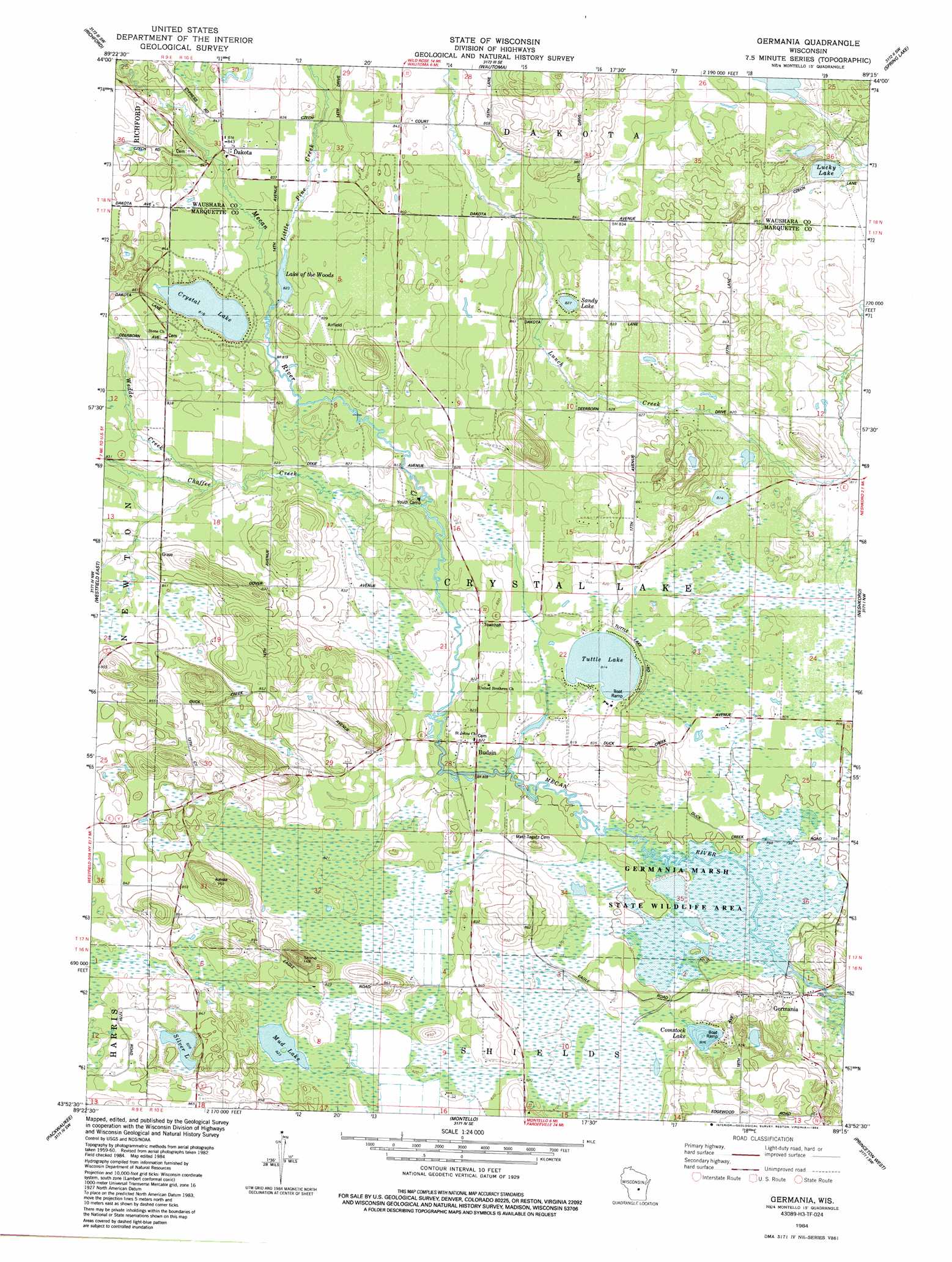
USGS Topo Quad 43089h3 - 1:24,000 scale
| Topo Map Name: | Germania |
| USGS Topo Quad ID: | 43089h3 |
| Print Size: | ca. 21 1/4" wide x 27" high |
| Southeast Coordinates: | 43.875° N latitude / 89.25° W longitude |
| Map Center Coordinates: | 43.9375° N latitude / 89.3125° W longitude |
| U.S. State: | WI |
| Filename: | o43089h3.jpg |
| Download Map JPG Image: | Germania topo map 1:24,000 scale |
| Map Type: | Topographic |
| Topo Series: | 7.5´ |
| Map Scale: | 1:24,000 |
| Source of Map Images: | United States Geological Survey (USGS) |
| Alternate Map Versions: |
Germania WI 1984, updated 1984 Download PDF Buy paper map Germania WI 2011 Download PDF Buy paper map Germania WI 2013 Download PDF Buy paper map Germania WI 2016 Download PDF Buy paper map |
1:24,000 Topo Quads surrounding Germania
Hancock |
Plainfield |
Wautoma Ne |
Wild Rose |
Saxeville |
Coloma |
Richford |
Wautoma |
Spring Lake |
Redgranite |
Westfield West |
Westfield East |
Germania |
Neshkoro |
Fairburn |
Oxford |
Packwaukee |
Montello |
Princeton West |
Princeton East |
Briggsville |
Endeavor |
Observatory Hill |
Marquette |
Manchester |
> Back to 43089e1 at 1:100,000 scale
> Back to 43088a1 at 1:250,000 scale
> Back to U.S. Topo Maps home
Germania topo map: Gazetteer
Germania: Dams
Germania 2wp1344 Dam elevation 243m 797′Lang G 781.4 Dam elevation 250m 820′
Wilcox E1423 Dam elevation 251m 823′
Wilcox G2982 Dam elevation 253m 830′
Germania: Lakes
Comstock Lake elevation 246m 807′Crystal Lake elevation 249m 816′
Lucky Lake elevation 245m 803′
Mud Lake elevation 251m 823′
Sandy Lake elevation 252m 826′
Silver Lake elevation 252m 826′
Tuttle Lake elevation 248m 813′
Germania: Parks
Comstock Bog-Meadow State Natural Area elevation 246m 807′Germania Marsh State Wildlife Area elevation 242m 793′
Germania Wet Prairie State Natural Area elevation 245m 803′
Germania: Populated Places
Budsin elevation 250m 820′Dakota elevation 256m 839′
Germania elevation 241m 790′
Germania: Reservoirs
155 Reservoir elevation 243m 797′2 Reservoir elevation 253m 830′
Alan Wilcox Flowage 2 elevation 251m 823′
Lake of the Woods elevation 250m 820′
Little Pine Pond 20 elevation 250m 820′
Germania: Streams
Chaffee Creek elevation 246m 807′Little Pine Creek elevation 250m 820′
Wedde Creek elevation 250m 820′
Germania: Summits
Stone Hill elevation 288m 944′Germania digital topo map on disk
Buy this Germania topo map showing relief, roads, GPS coordinates and other geographical features, as a high-resolution digital map file on DVD: