Reedsburg West Topo Map Wisconsin
To zoom in, hover over the map of Reedsburg West
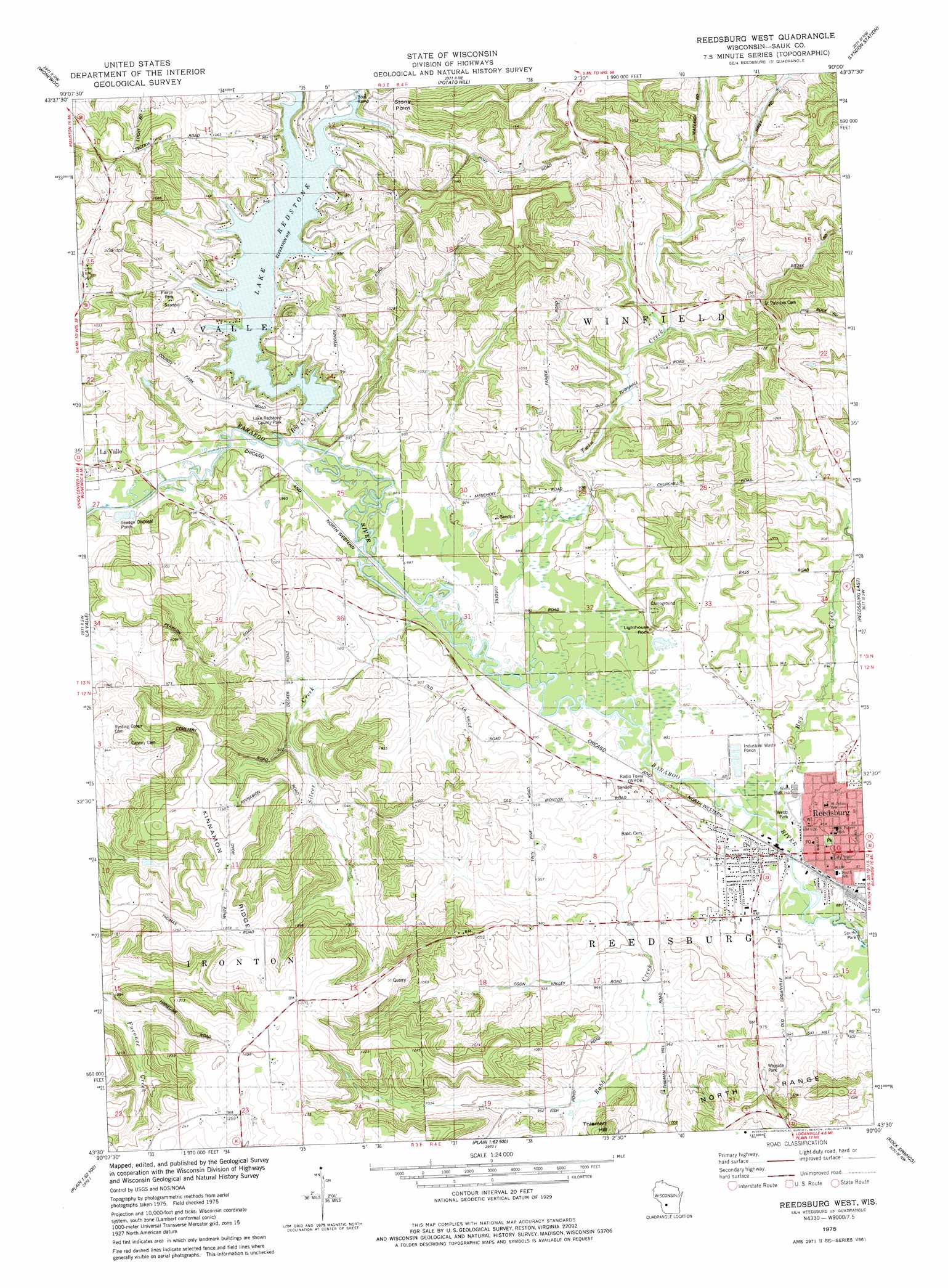
USGS Topo Quad 43090e1 - 1:24,000 scale
| Topo Map Name: | Reedsburg West |
| USGS Topo Quad ID: | 43090e1 |
| Print Size: | ca. 21 1/4" wide x 27" high |
| Southeast Coordinates: | 43.5° N latitude / 90° W longitude |
| Map Center Coordinates: | 43.5625° N latitude / 90.0625° W longitude |
| U.S. State: | WI |
| Filename: | o43090e1.jpg |
| Download Map JPG Image: | Reedsburg West topo map 1:24,000 scale |
| Map Type: | Topographic |
| Topo Series: | 7.5´ |
| Map Scale: | 1:24,000 |
| Source of Map Images: | United States Geological Survey (USGS) |
| Alternate Map Versions: |
Reedsburg West WI 1975, updated 1978 Download PDF Buy paper map Reedsburg West WI 2010 Download PDF Buy paper map Reedsburg West WI 2013 Download PDF Buy paper map Reedsburg West WI 2016 Download PDF Buy paper map |
1:24,000 Topo Quads surrounding Reedsburg West
Kendall East |
New Lisbon South |
Mauston |
Round Bluff |
Easton |
Hillsboro |
Wonewoc |
Potato Hill |
Lyndon Station |
Wisconsin Dells North |
Valton |
La Valle |
Reedsburg West |
Reedsburg East |
Wisconsin Dells South |
Rockeridge |
Lime Ridge |
Loganville |
Rock Springs |
North Freedom |
Sectonville |
Bear Valley |
Plain |
Black Hawk |
Sauk Prairie |
> Back to 43090e1 at 1:100,000 scale
> Back to 43090a1 at 1:250,000 scale
> Back to U.S. Topo Maps home
Reedsburg West topo map: Gazetteer
Reedsburg West: Capes
Stony Point elevation 324m 1062′Reedsburg West: Dams
Lake Redstone 2WP1970 Dam elevation 280m 918′Reedsburg West: Parks
Lake Redstone County Park elevation 301m 987′Pierce Park elevation 290m 951′
Ramsey Park elevation 272m 892′
Reed Park elevation 274m 898′
South Park elevation 266m 872′
Stone Park elevation 268m 879′
Webb Park elevation 268m 879′
Reedsburg West: Pillars
Lighthouse Rock elevation 278m 912′Reedsburg West: Populated Places
Reedsburg elevation 275m 902′Reedsburg West: Post Offices
Reedsburg Post Office elevation 271m 889′Reedsburg West: Reservoirs
Lake Redstone elevation 280m 918′Lake Redstone 30 elevation 279m 915′
Reedsburg West: Ridges
Kinnamon Ridge elevation 378m 1240′Reedsburg West: Streams
Babb Creek elevation 266m 872′Big Creek elevation 267m 875′
East Branch Big Creek elevation 279m 915′
Hay Creek elevation 265m 869′
Silver Creek elevation 268m 879′
Twin Creek elevation 267m 875′
West Branch Big Creek elevation 279m 915′
Reedsburg West: Summits
Thieman Hill elevation 353m 1158′Reedsburg West digital topo map on disk
Buy this Reedsburg West topo map showing relief, roads, GPS coordinates and other geographical features, as a high-resolution digital map file on DVD: