Tomah Topo Map Wisconsin
To zoom in, hover over the map of Tomah
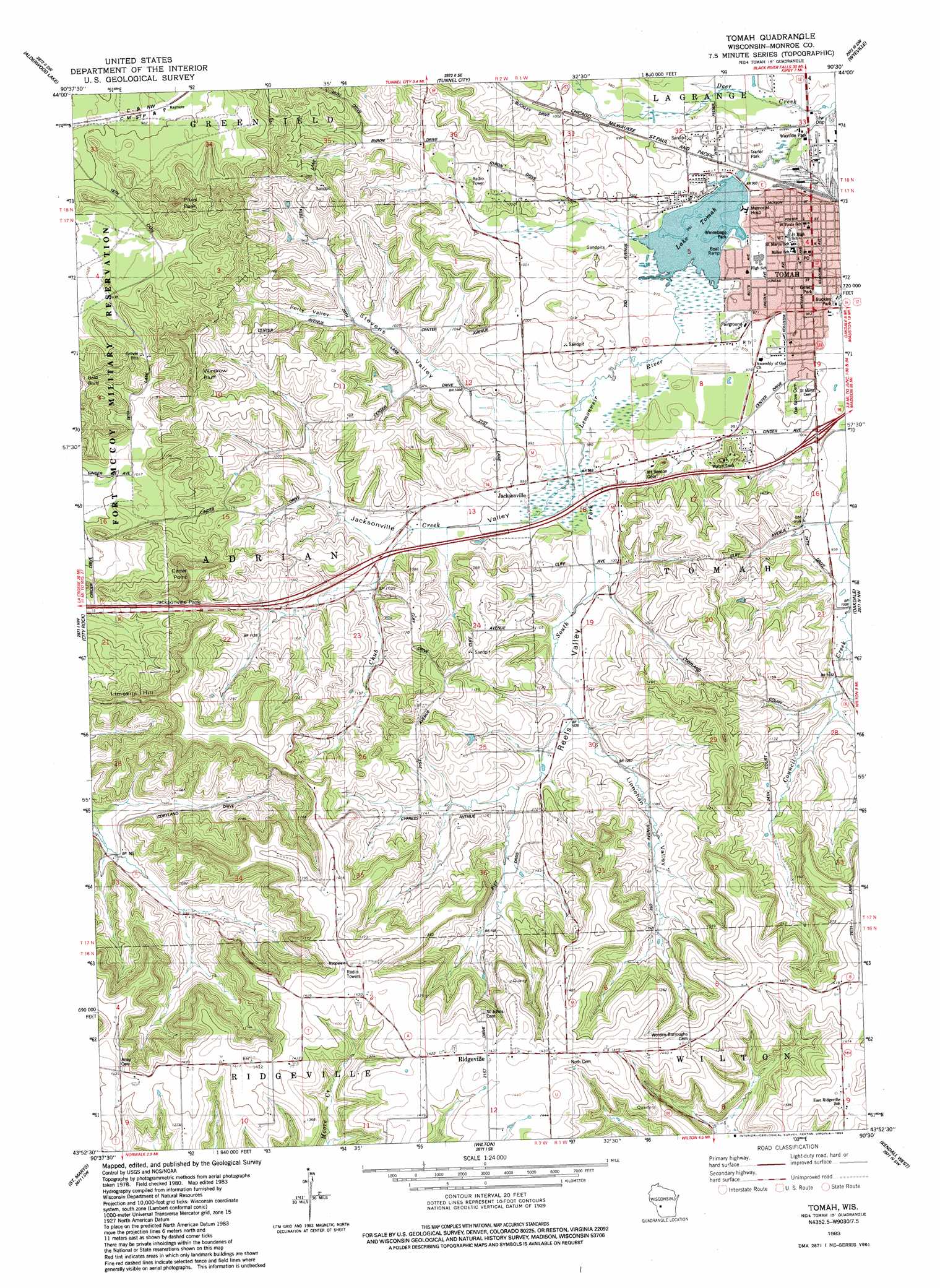
USGS Topo Quad 43090h5 - 1:24,000 scale
| Topo Map Name: | Tomah |
| USGS Topo Quad ID: | 43090h5 |
| Print Size: | ca. 21 1/4" wide x 27" high |
| Southeast Coordinates: | 43.875° N latitude / 90.5° W longitude |
| Map Center Coordinates: | 43.9375° N latitude / 90.5625° W longitude |
| U.S. State: | WI |
| Filename: | o43090h5.jpg |
| Download Map JPG Image: | Tomah topo map 1:24,000 scale |
| Map Type: | Topographic |
| Topo Series: | 7.5´ |
| Map Scale: | 1:24,000 |
| Source of Map Images: | United States Geological Survey (USGS) |
| Alternate Map Versions: |
Tomah NE WI 1976, updated 1978 Download PDF Buy paper map Tomah NE WI 1976, updated 1986 Download PDF Buy paper map Tomah WI 1983, updated 1984 Download PDF Buy paper map Tomah WI 2010 Download PDF Buy paper map Tomah WI 2013 Download PDF Buy paper map Tomah WI 2016 Download PDF Buy paper map |
1:24,000 Topo Quads surrounding Tomah
Shamrock |
Millston |
Warrens West |
Warrens East |
Mather |
Cataract |
Alderwood Lake |
Tunnel City |
Wyeville |
Shennington |
Sparta |
City Rock |
Tomah |
Oakdale |
Camp Douglas |
Melvina |
Saint Marys |
Wilton |
Kendall West |
Kendall East |
Westby |
Dell |
Ontario |
Trippville |
Hillsboro |
> Back to 43090e1 at 1:100,000 scale
> Back to 43090a1 at 1:250,000 scale
> Back to U.S. Topo Maps home
Tomah topo map: Gazetteer
Tomah: Airports
Tomah Memorial Hospital Heliport elevation 294m 964′Wisconsin State Patrol District 5 Heliport elevation 343m 1125′
Tomah: Capes
Cedar Point elevation 410m 1345′Tomah: Cliffs
Windrow Bluff elevation 389m 1276′Tomah: Dams
Tomah Lake 2 WP 258 Dam elevation 293m 961′Tomah: Gaps
Jacksonville Pass elevation 366m 1200′Tomah: Parks
Buckley Park elevation 297m 974′Butts Park elevation 291m 954′
Gillett PArk elevation 299m 980′
Hiawatha Park elevation 294m 964′
Jodi Circle Park elevation 297m 974′
Lake Park elevation 294m 964′
Recreation Park elevation 297m 974′
Winnebago Park elevation 297m 974′
Tomah: Pillars
Engine Rock elevation 344m 1128′Tomah: Populated Places
Jacksonville elevation 311m 1020′Raymore elevation 301m 987′
Tomah elevation 296m 971′
Tomah: Post Offices
Tomah Post Office elevation 296m 971′Tomah: Reservoirs
Lake Tomah elevation 293m 961′Lake Tomah 26 elevation 293m 961′
Tomah: Streams
Chub Creek elevation 297m 974′Tomah: Summits
Limekiln Hill elevation 368m 1207′Pikes Peak elevation 369m 1210′
Tomah: Valleys
Jacksonville Valley elevation 297m 974′Linnehan Valley elevation 314m 1030′
Perry Valley elevation 317m 1040′
Reels Valley elevation 298m 977′
Stevens Valley elevation 300m 984′
Tomah digital topo map on disk
Buy this Tomah topo map showing relief, roads, GPS coordinates and other geographical features, as a high-resolution digital map file on DVD: