Prairie Du Chien Topo Map Iowa
To zoom in, hover over the map of Prairie Du Chien
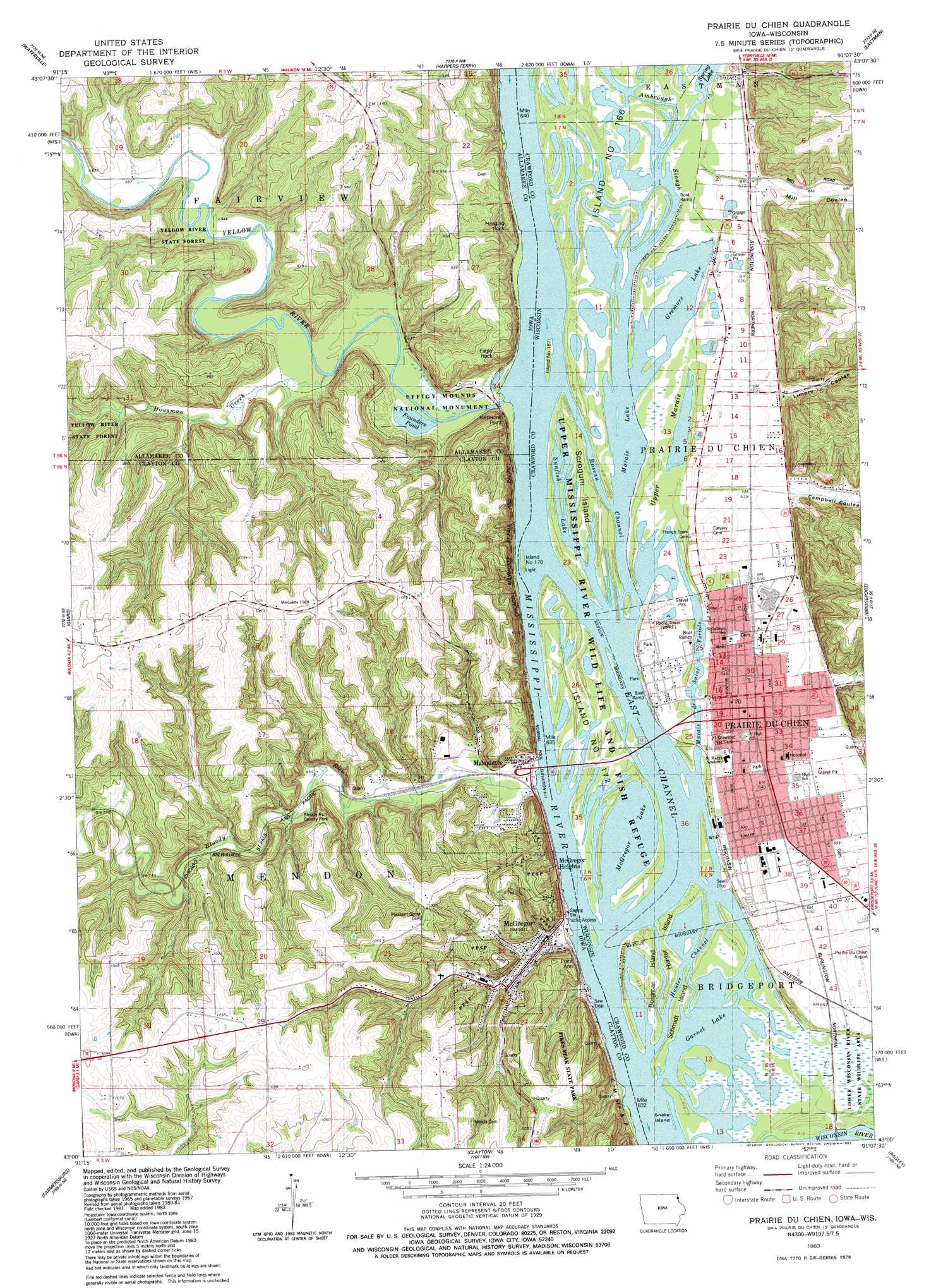
USGS Topo Quad 43091a2 - 1:24,000 scale
| Topo Map Name: | Prairie Du Chien |
| USGS Topo Quad ID: | 43091a2 |
| Print Size: | ca. 21 1/4" wide x 27" high |
| Southeast Coordinates: | 43° N latitude / 91.125° W longitude |
| Map Center Coordinates: | 43.0625° N latitude / 91.1875° W longitude |
| U.S. States: | IA, WI |
| Filename: | o43091a2.jpg |
| Download Map JPG Image: | Prairie Du Chien topo map 1:24,000 scale |
| Map Type: | Topographic |
| Topo Series: | 7.5´ |
| Map Scale: | 1:24,000 |
| Source of Map Images: | United States Geological Survey (USGS) |
| Alternate Map Versions: |
Prairie Du Chien WI 1983, updated 1983 Download PDF Buy paper map Prairie du Chien WI 2010 Download PDF Buy paper map Prairie du Chien WI 2013 Download PDF Buy paper map Prairie du Chien WI 2015 Download PDF Buy paper map |
1:24,000 Topo Quads surrounding Prairie Du Chien
Waukon |
Church |
Lansing |
Ferryville |
Mount Sterling |
Rossville |
Waterville |
Harpers Ferry |
Eastman |
Crowley Ridge |
Monona |
Giard |
Prairie Du Chien |
Bridgeport |
Wauzeka West |
Saint Olaf |
Farmersburg |
Clayton |
Bagley |
Bloomington |
Elkader |
Littleport |
Garnavillo |
Guttenberg |
Beetown |
> Back to 43091a1 at 1:100,000 scale
> Back to 43090a1 at 1:250,000 scale
> Back to U.S. Topo Maps home
Prairie Du Chien topo map: Gazetteer
Prairie Du Chien: Channels
East Channel elevation 187m 613′Hunter Channel elevation 187m 613′
Roseau Channel elevation 187m 613′
Prairie Du Chien: Cliffs
Eagle Rock elevation 285m 935′Fire Point elevation 286m 938′
Nezekaw Point elevation 259m 849′
Point Ann elevation 200m 656′
Prairie Du Chien: Guts
Ambrough Slough elevation 187m 613′Marais de Saint Feriole elevation 188m 616′
Prairie Du Chien: Islands
Bergman Island elevation 187m 613′Hunter Island elevation 187m 613′
Island Number One Hundred Seventy elevation 188m 616′
Island Number One Hundred Seventy-two elevation 187m 613′
Island Number One Hundred Sixty-seven elevation 187m 613′
Island Number One Hundred Sixty-six elevation 187m 613′
Saint Feriole Island elevation 190m 623′
Schmidt Island elevation 187m 613′
Scrogum Island elevation 188m 616′
Snake Island elevation 187m 613′
Prairie Du Chien: Lakes
Founders Pond elevation 188m 616′Garnet Lake elevation 187m 613′
Gremore Lake elevation 187m 613′
Marais Lake elevation 187m 613′
McGregor Lake elevation 187m 613′
Spring Lake elevation 188m 616′
Sunfish Lake elevation 186m 610′
Prairie Du Chien: Parks
Beginning of Old Military Trail Historical Marker elevation 188m 616′Bloody Run County Park elevation 203m 666′
Bloody Run Wildlife Management Area elevation 226m 741′
Cecil Smith Athletic Field elevation 194m 636′
Giard Tract State Historical Marker elevation 197m 646′
Lawler Park elevation 188m 616′
Limery Ridge Savanna State Natural Area elevation 306m 1003′
Marquette City Park elevation 197m 646′
McGregor River Front Park elevation 194m 636′
Northeast Iowas First White Farmer Historical Marker elevation 188m 616′
Prairie Du Chien: Pillars
Hanging Rock elevation 240m 787′Prairie Du Chien: Populated Places
La Prairie Retirement Village elevation 191m 626′Marquette elevation 191m 626′
McGregor elevation 211m 692′
McGregor Heights elevation 286m 938′
Prairie du Chien elevation 195m 639′
Selchs Mobile Home Park elevation 200m 656′
West Yards elevation 196m 643′
Yellow River elevation 202m 662′
Prairie Du Chien: Post Offices
Marquette Post Office elevation 191m 626′McGregor Post Office elevation 211m 692′
Nezeka Post Office (historical) elevation 193m 633′
Prairie du Chien Post Office elevation 198m 649′
Prairie Du Chien: Streams
Bloody Run elevation 189m 620′Dousman Creek elevation 189m 620′
Yellow River elevation 187m 613′
Prairie Du Chien: Swamps
Upper Marais elevation 188m 616′Prairie Du Chien: Valleys
Campbell Coulee elevation 200m 656′Limery Coulee elevation 200m 656′
Mill Coulee elevation 195m 639′
Prairie Du Chien digital topo map on disk
Buy this Prairie Du Chien topo map showing relief, roads, GPS coordinates and other geographical features, as a high-resolution digital map file on DVD: