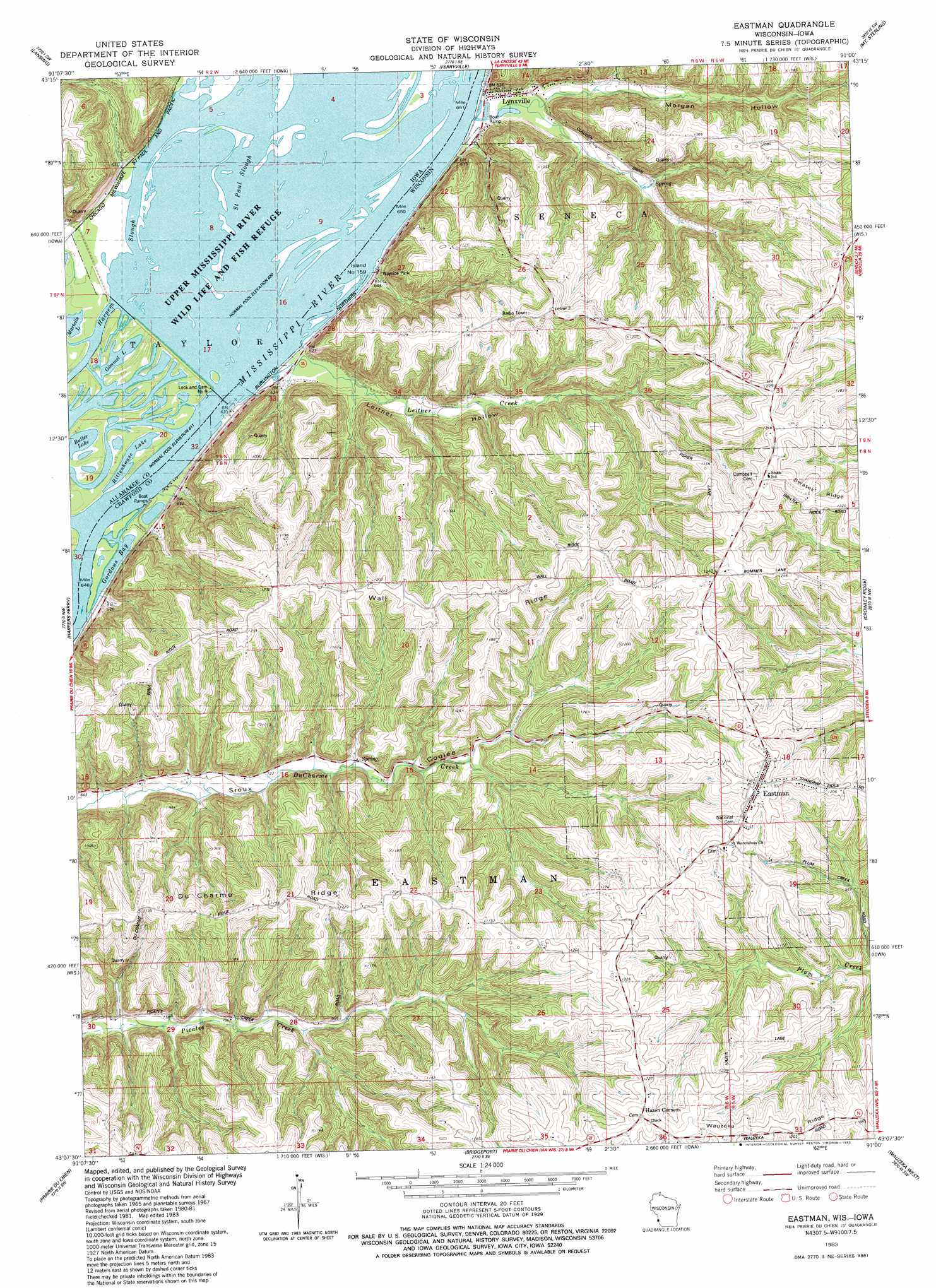
Eastman Topo Map Wisconsin
To zoom in, hover over the map of Eastman
USGS Topo Quad 43091b1 - 1:24,000 scale
| Topo Map Name: | Eastman |
| USGS Topo Quad ID: | 43091b1 |
| Print Size: | ca. 21 1/4" wide x 27" high |
| Southeast Coordinates: | 43.125° N latitude / 91° W longitude |
| Map Center Coordinates: | 43.1875° N latitude / 91.0625° W longitude |
| U.S. States: | WI, IA |
| Filename: | o43091b1.jpg |
| Download Map JPG Image: | Eastman topo map 1:24,000 scale |
| Map Type: | Topographic |
| Topo Series: | 7.5´ |
| Map Scale: | 1:24,000 |
| Source of Map Images: | United States Geological Survey (USGS) |
| Alternate Map Versions: |
Eastman WI 1983, updated 1983 Download PDF Buy paper map Eastman WI 2010 Download PDF Buy paper map Eastman WI 2013 Download PDF Buy paper map Eastman WI 2015 Download PDF Buy paper map |
1:24,000 Topo Quads surrounding Eastman
New Albin |
De Soto |
Retreat |
Rising Sun |
Readstown |
Church |
Lansing |
Ferryville |
Mount Sterling |
Gays Mills |
Waterville |
Harpers Ferry |
Eastman |
Crowley Ridge |
Steuben |
Giard |
Prairie Du Chien |
Bridgeport |
Wauzeka West |
Wauzeka East |
Farmersburg |
Clayton |
Bagley |
Bloomington |
Mount Hope |
> Back to 43091a1 at 1:100,000 scale
> Back to 43090a1 at 1:250,000 scale
> Back to U.S. Topo Maps home
Eastman topo map: Gazetteer
Eastman: Bays
Gordons Bay elevation 186m 610′Eastman: Channels
Saint Paul Slough elevation 188m 616′Eastman: Dams
Lock and Dam No elevation 188m 616′Lock and Dam Number 9 elevation 187m 613′
Eastman: Guts
Shulz Crossing Slough elevation 212m 695′Eastman: Islands
Island Number One Hundred Fifty-nine elevation 188m 616′Eastman: Lakes
Butler Lake elevation 187m 613′Gimmel Lake elevation 186m 610′
Rittenhouse Lake elevation 187m 613′
Eastman: Populated Places
Eastman elevation 371m 1217′Lynxville elevation 190m 623′
Eastman: Reservoirs
Pool Nine 66600 elevation 297m 974′Eastman: Ridges
Du Charme Ridge elevation 357m 1171′Wall Ridge elevation 354m 1161′
Eastman: Streams
Leitner Creek elevation 189m 620′Oil Spring Creek elevation 187m 613′
Eastman: Valleys
Leitner Hollow elevation 188m 616′Morgan Hollow elevation 195m 639′
Eastman digital topo map on disk
Buy this Eastman topo map showing relief, roads, GPS coordinates and other geographical features, as a high-resolution digital map file on DVD: