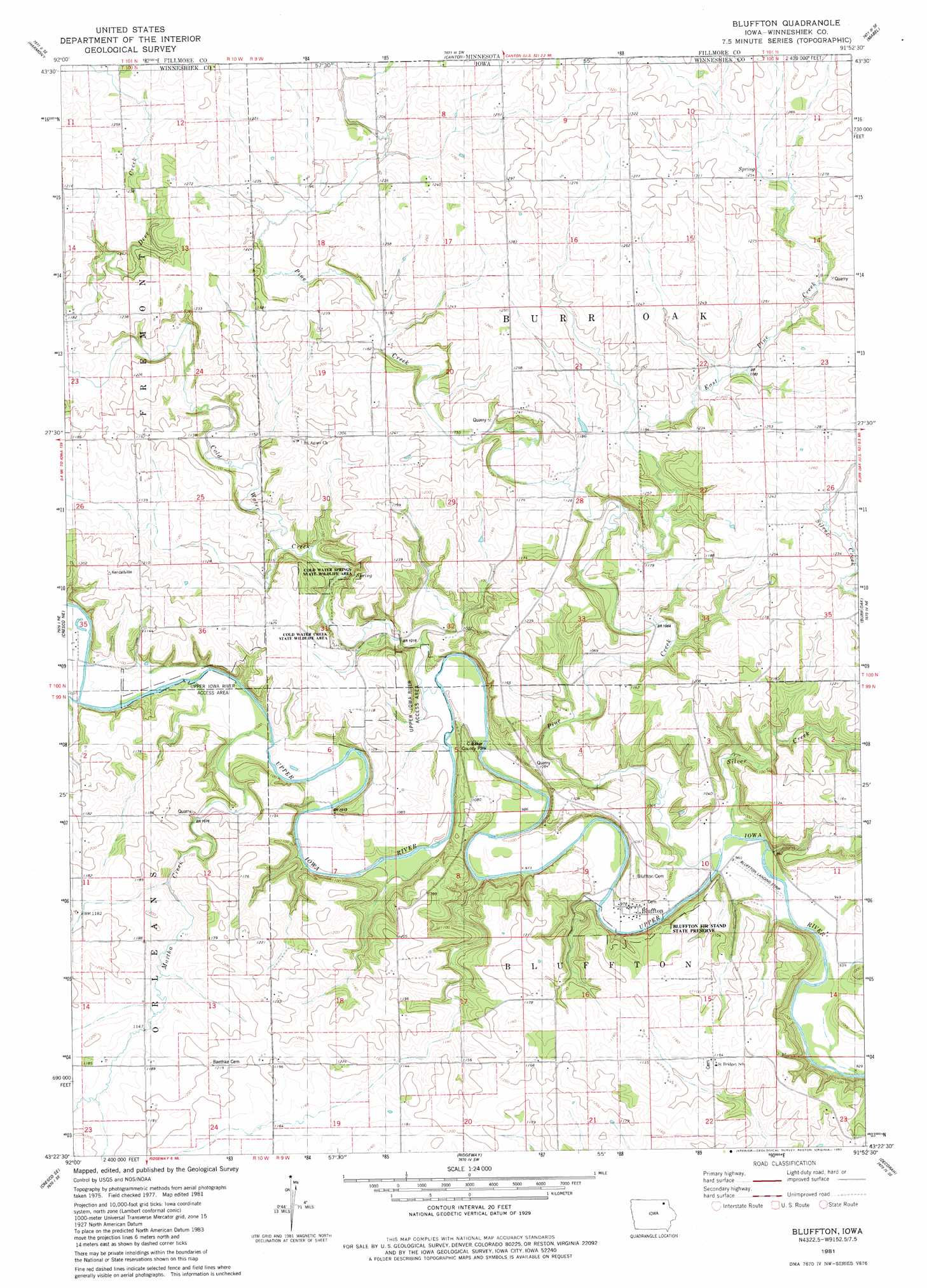
Bluffton Topo Map Iowa
To zoom in, hover over the map of Bluffton
USGS Topo Quad 43091d8 - 1:24,000 scale
| Topo Map Name: | Bluffton |
| USGS Topo Quad ID: | 43091d8 |
| Print Size: | ca. 21 1/4" wide x 27" high |
| Southeast Coordinates: | 43.375° N latitude / 91.875° W longitude |
| Map Center Coordinates: | 43.4375° N latitude / 91.9375° W longitude |
| U.S. State: | IA |
| Filename: | o43091d8.jpg |
| Download Map JPG Image: | Bluffton topo map 1:24,000 scale |
| Map Type: | Topographic |
| Topo Series: | 7.5´ |
| Map Scale: | 1:24,000 |
| Source of Map Images: | United States Geological Survey (USGS) |
| Alternate Map Versions: |
Decorah 2 NW IA 1975, updated 1977 Download PDF Buy paper map Bluffton IA 1981, updated 1982 Download PDF Buy paper map Bluffton IA 2010 Download PDF Buy paper map Bluffton IA 2013 Download PDF Buy paper map Bluffton IA 2015 Download PDF Buy paper map |
1:24,000 Topo Quads surrounding Bluffton
Fountain |
Preston |
Lanesboro |
Bratsberg |
Yucatan |
Greenleafton |
Harmony |
Canton |
Mabel |
Spring Grove |
Cresco Nw |
Cresco Ne |
Bluffton |
Burr Oak |
Highlandville |
Cresco Sw |
Cresco Se |
Ridgeway |
Decorah |
Freeport |
Saude |
Protivin |
Fort Atkinson |
Calmar |
Postville Nw |
> Back to 43091a1 at 1:100,000 scale
> Back to 43090a1 at 1:250,000 scale
> Back to U.S. Topo Maps home
Bluffton topo map: Gazetteer
Bluffton: Airports
Bluffton Landing Strip elevation 292m 958′Bluffton: Areas
Cold Water Springs State Wildlife Area elevation 339m 1112′Bluffton: Bridges
Gilliece Bridge elevation 306m 1003′Lower Bluffton Bridge elevation 292m 958′
Upper Bluffton Bridge (historical) elevation 292m 958′
Bluffton: Parks
Bluffton Fir Stand State Preserve elevation 342m 1122′C Baker County Park elevation 305m 1000′
Chimney Rock Park elevation 306m 1003′
Bluffton: Populated Places
Bluffton elevation 298m 977′Bluffton: Post Offices
Bluffton Post Office (historical) elevation 298m 977′Plymouth Rock Post Office (historical) elevation 315m 1033′
Bluffton: Streams
Cold Water Creek elevation 301m 987′East Pine Creek elevation 334m 1095′
Pine Creek elevation 292m 958′
Pine Creek elevation 292m 958′
Silver Creek elevation 290m 951′
Silver Creek elevation 315m 1033′
Bluffton digital topo map on disk
Buy this Bluffton topo map showing relief, roads, GPS coordinates and other geographical features, as a high-resolution digital map file on DVD: