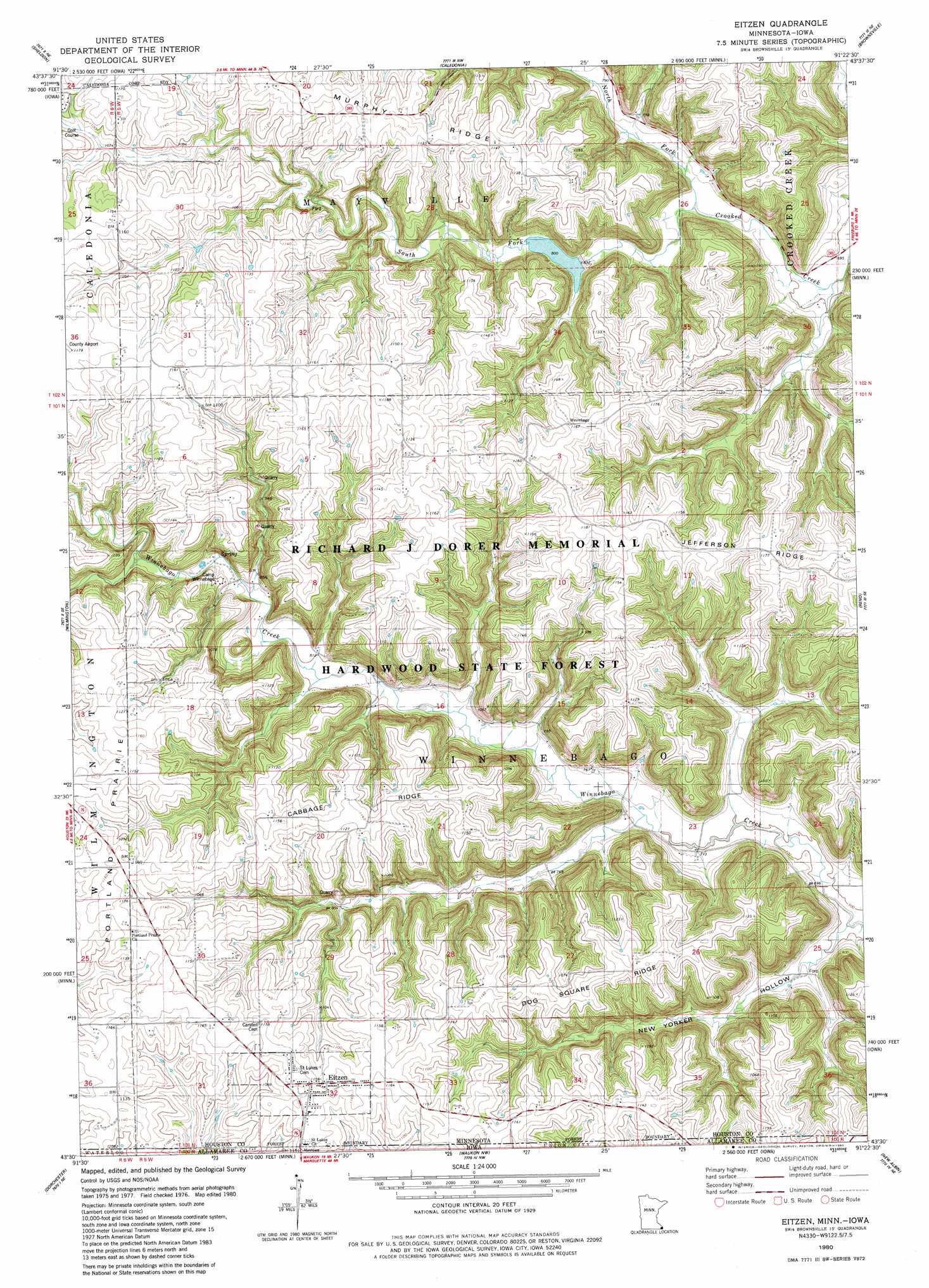
Eitzen Topo Map Minnesota
To zoom in, hover over the map of Eitzen
USGS Topo Quad 43091e4 - 1:24,000 scale
| Topo Map Name: | Eitzen |
| USGS Topo Quad ID: | 43091e4 |
| Print Size: | ca. 21 1/4" wide x 27" high |
| Southeast Coordinates: | 43.5° N latitude / 91.375° W longitude |
| Map Center Coordinates: | 43.5625° N latitude / 91.4375° W longitude |
| U.S. States: | MN, IA |
| Filename: | o43091e4.jpg |
| Download Map JPG Image: | Eitzen topo map 1:24,000 scale |
| Map Type: | Topographic |
| Topo Series: | 7.5´ |
| Map Scale: | 1:24,000 |
| Source of Map Images: | United States Geological Survey (USGS) |
| Alternate Map Versions: |
Eitzen MN 1980, updated 1980 Download PDF Buy paper map Eitzen MN 2010 Download PDF Buy paper map Eitzen MN 2013 Download PDF Buy paper map Eitzen MN 2016 Download PDF Buy paper map |
1:24,000 Topo Quads surrounding Eitzen
Rushford East |
Houston |
Mound Prairie |
La Crescent |
La Crosse |
Yucatan |
Sheldon |
Caledonia |
Brownsville |
Stoddard |
Spring Grove |
Wilmington |
Eitzen |
Reno |
Genoa |
Highlandville |
Dorchester |
Waukon Nw |
New Albin |
De Soto |
Freeport |
Hanover |
Waukon |
Church |
Lansing |
> Back to 43091e1 at 1:100,000 scale
> Back to 43090a1 at 1:250,000 scale
> Back to U.S. Topo Maps home
Eitzen topo map: Gazetteer
Eitzen: Dams
Crooked Creek S-3 Dam elevation 333m 1092′R3 Structure Dam elevation 234m 767′
Structure R-4 Dam elevation 236m 774′
Eitzen: Flats
Portland Prairie elevation 340m 1115′Eitzen: Populated Places
Eitzen elevation 352m 1154′Eitzen: Post Offices
Eitzen Post Office elevation 355m 1164′Eitzen: Reservoirs
R3 Pool elevation 234m 767′R-4 Pool elevation 236m 774′
Eitzen: Ridges
Cabbage Ridge elevation 348m 1141′Dog Square Ridge elevation 339m 1112′
Murphy Ridge elevation 352m 1154′
Eitzen: Streams
North Fork Crooked Creek elevation 219m 718′South Fork Crooked Creek elevation 219m 718′
Eitzen: Valleys
New Yorker Hollow elevation 209m 685′Eitzen digital topo map on disk
Buy this Eitzen topo map showing relief, roads, GPS coordinates and other geographical features, as a high-resolution digital map file on DVD: