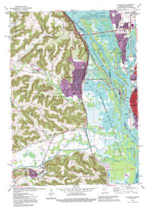
La Crescent Topo Map Minnesota
To zoom in, hover over the map of La Crescent
USGS Topo Quad 43091g3 - 1:24,000 scale
| Topo Map Name: | La Crescent |
| USGS Topo Quad ID: | 43091g3 |
| Print Size: | ca. 21 1/4" wide x 27" high |
| Southeast Coordinates: | 43.75° N latitude / 91.25° W longitude |
| Map Center Coordinates: | 43.8125° N latitude / 91.3125° W longitude |
| U.S. States: | MN, WI |
| Filename: | o43091g3.jpg |
| Download Map JPG Image: | La Crescent topo map 1:24,000 scale |
| Map Type: | Topographic |
| Topo Series: | 7.5´ |
| Map Scale: | 1:24,000 |
| Source of Map Images: | United States Geological Survey (USGS) |
| Alternate Map Versions: |
La Crescent MN 1973, updated 1976 Download PDF Buy paper map La Crescent MN 1991, updated 1995 Download PDF Buy paper map La Crescent MN 2010 Download PDF Buy paper map La Crescent MN 2013 Download PDF Buy paper map La Crescent MN 2016 Download PDF Buy paper map |
1:24,000 Topo Quads surrounding La Crescent
> Back to 43091e1 at 1:100,000 scale
> Back to 43090a1 at 1:250,000 scale
> Back to U.S. Topo Maps home
La Crescent topo map: Gazetteer
La Crescent: Bays
Richmond Bay elevation 192m 629′La Crescent: Beaches
Black River Public Beach elevation 193m 633′Pettibone Beach elevation 193m 633′
La Crescent: Bridges
Dresbach Bridge elevation 192m 629′La Crescent: Channels
West Channel elevation 192m 629′La Crescent: Dams
James Bennet Group Structure Dam elevation 230m 754′Lock and Dam Number 7 elevation 195m 639′
Lock and Dam Number 7 elevation 193m 633′
La Crescent: Guts
Broken Arrow Slough elevation 192m 629′French Slough elevation 192m 629′
La Plume Slough elevation 192m 629′
Smith Slough elevation 192m 629′
La Crescent: Islands
Barron Island elevation 193m 633′French Island elevation 201m 659′
Isle La Plume elevation 199m 652′
Minnesota Island elevation 193m 633′
Taylor Island elevation 195m 639′
La Crescent: Lakes
Blue Lake elevation 192m 629′French Lake elevation 192m 629′
Round Lake elevation 192m 629′
Target Lake elevation 192m 629′
La Crescent: Parks
Abnet Field elevation 207m 679′Como Falls Park elevation 199m 652′
Hokah City Park elevation 219m 718′
Houska Park elevation 195m 639′
John S Harris Park elevation 221m 725′
Kistler Park elevation 207m 679′
Legion Ball Field elevation 207m 679′
Minnesotas Fashionable Tour Historical Marker elevation 202m 662′
Pettibone Park elevation 193m 633′
Riverside Park elevation 195m 639′
Valley South Park elevation 212m 695′
Veteran's Park elevation 207m 679′
La Crescent: Populated Places
French Island elevation 198m 649′Hills Mobile Home Park elevation 207m 679′
Hokah elevation 214m 702′
Kistler Mobile Home Park elevation 207m 679′
La Crescent elevation 207m 679′
River Junction elevation 199m 652′
Shepardson's Park elevation 205m 672′
Thunderbird Mobile Home Park elevation 213m 698′
Village Terrace elevation 234m 767′
West La Crosse elevation 197m 646′
La Crescent: Post Offices
Hokah Post Office elevation 210m 688′La Crescent Post Office elevation 207m 679′
La Crescent: Reservoirs
Lake Onalaska elevation 193m 633′Pool 7 elevation 195m 639′
La Crescent: Streams
Black River elevation 192m 629′Butterfield Creek elevation 207m 679′
La Crosse River elevation 192m 629′
Pine Creek elevation 192m 629′
Root River elevation 192m 629′
Thompson Creek elevation 198m 649′
La Crescent: Valleys
Burns Valley elevation 213m 698′Pfeffer Valley elevation 198m 649′
La Crescent digital topo map on disk
Buy this La Crescent topo map showing relief, roads, GPS coordinates and other geographical features, as a high-resolution digital map file on DVD:


