Pilot Mound Topo Map Minnesota
To zoom in, hover over the map of Pilot Mound
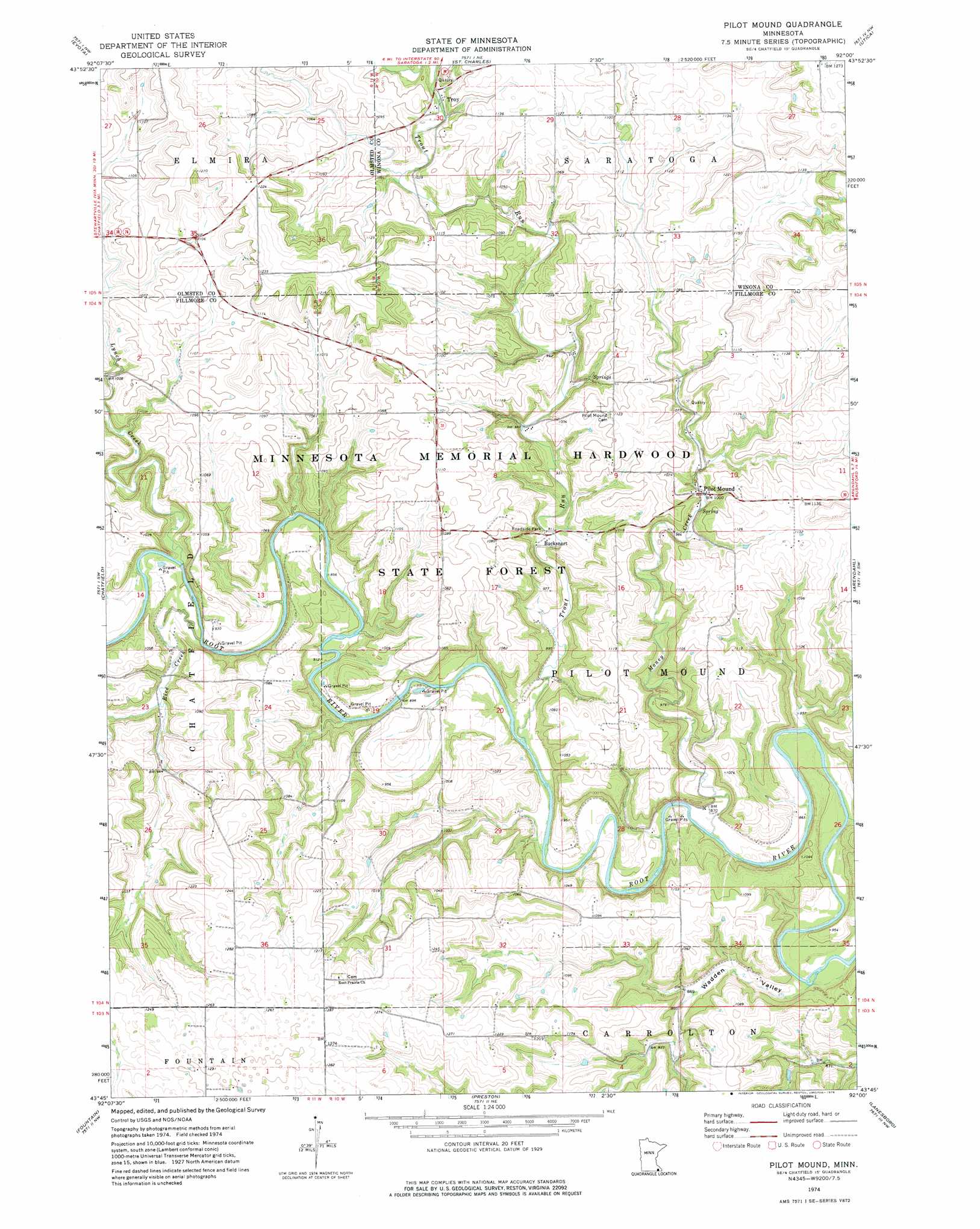
USGS Topo Quad 43092g1 - 1:24,000 scale
| Topo Map Name: | Pilot Mound |
| USGS Topo Quad ID: | 43092g1 |
| Print Size: | ca. 21 1/4" wide x 27" high |
| Southeast Coordinates: | 43.75° N latitude / 92° W longitude |
| Map Center Coordinates: | 43.8125° N latitude / 92.0625° W longitude |
| U.S. State: | MN |
| Filename: | o43092g1.jpg |
| Download Map JPG Image: | Pilot Mound topo map 1:24,000 scale |
| Map Type: | Topographic |
| Topo Series: | 7.5´ |
| Map Scale: | 1:24,000 |
| Source of Map Images: | United States Geological Survey (USGS) |
| Alternate Map Versions: |
Pilot Mound MN 1974, updated 1976 Download PDF Buy paper map Pilot Mound MN 2010 Download PDF Buy paper map Pilot Mound MN 2013 Download PDF Buy paper map Pilot Mound MN 2016 Download PDF Buy paper map |
1:24,000 Topo Quads surrounding Pilot Mound
Chester |
Plainview Sw |
Elba |
Altura |
Rollingstone |
Marion |
Eyota |
Saint Charles |
Utica |
Lewiston |
Washington |
Chatfield |
Pilot Mound |
Arendahl |
Rushford West |
Wykoff |
Fountain |
Preston |
Lanesboro |
Bratsberg |
Cherry Grove |
Greenleafton |
Harmony |
Canton |
Mabel |
> Back to 43092e1 at 1:100,000 scale
> Back to 43092a1 at 1:250,000 scale
> Back to U.S. Topo Maps home
Pilot Mound topo map: Gazetteer
Pilot Mound: Dams
Donald Lawstuen Dam elevation 314m 1030′Donald Wangen Dam elevation 316m 1036′
Lagoon Park Dam elevation 338m 1108′
North Branch Root River Dam elevation 255m 836′
Stanley Harcey Dam elevation 336m 1102′
T Rain Structure Dam elevation 349m 1145′
Pilot Mound: Populated Places
Bucksnort elevation 279m 915′Troy elevation 316m 1036′
Pilot Mound: Post Offices
Pilotmound Post Office (historical) elevation 305m 1000′Troy Post Office (historical) elevation 316m 1036′
Pilot Mound: Reservoirs
North Branch Root River Reservoir elevation 255m 836′Pilot Mound: Streams
Lynch Creek elevation 275m 902′Money Creek elevation 258m 846′
Rice Creek elevation 274m 898′
Trout Run elevation 266m 872′
Pilot Mound: Valleys
Wadden Valley elevation 258m 846′Pilot Mound digital topo map on disk
Buy this Pilot Mound topo map showing relief, roads, GPS coordinates and other geographical features, as a high-resolution digital map file on DVD: