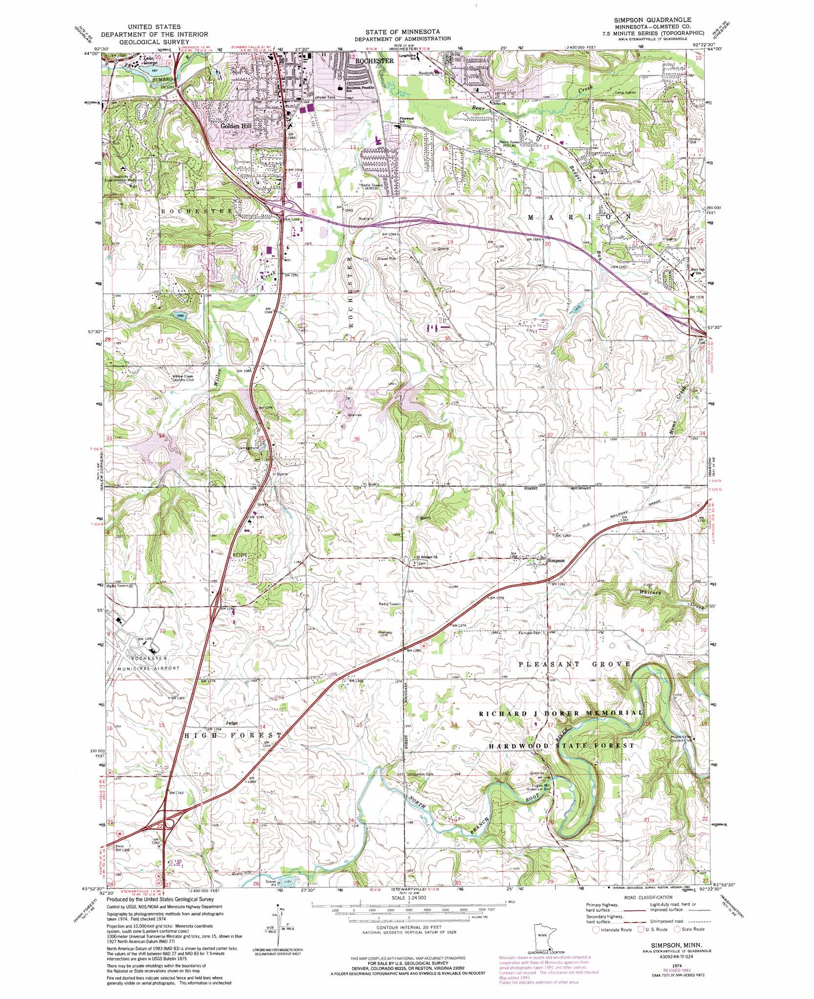
Simpson Topo Map Minnesota
To zoom in, hover over the map of Simpson
USGS Topo Quad 43092h4 - 1:24,000 scale
| Topo Map Name: | Simpson |
| USGS Topo Quad ID: | 43092h4 |
| Print Size: | ca. 21 1/4" wide x 27" high |
| Southeast Coordinates: | 43.875° N latitude / 92.375° W longitude |
| Map Center Coordinates: | 43.9375° N latitude / 92.4375° W longitude |
| U.S. State: | MN |
| Filename: | o43092h4.jpg |
| Download Map JPG Image: | Simpson topo map 1:24,000 scale |
| Map Type: | Topographic |
| Topo Series: | 7.5´ |
| Map Scale: | 1:24,000 |
| Source of Map Images: | United States Geological Survey (USGS) |
| Alternate Map Versions: |
Simpson MN 1974, updated 1976 Download PDF Buy paper map Simpson MN 1974, updated 1993 Download PDF Buy paper map Simpson MN 2010 Download PDF Buy paper map Simpson MN 2013 Download PDF Buy paper map Simpson MN 2016 Download PDF Buy paper map |
1:24,000 Topo Quads surrounding Simpson
Pine Island |
Oronoco |
Zumbro Lake |
Millville |
Plainview |
Byron |
Douglas |
Rochester |
Chester |
Plainview Sw |
Rock Dell |
Salem Corners |
Simpson |
Marion |
Eyota |
High Forest Sw |
High Forest |
Stewartville |
Washington |
Chatfield |
Dexter |
Grand Meadow |
Spring Valley |
Wykoff |
Fountain |
> Back to 43092e1 at 1:100,000 scale
> Back to 43092a1 at 1:250,000 scale
> Back to U.S. Topo Maps home
Simpson topo map: Gazetteer
Simpson: Airports
Rochester Municipal Airport elevation 395m 1295′Simpson: Crossings
Interchange 209AB elevation 384m 1259′Simpson: Lakes
Lake George elevation 304m 997′Simpson: Parks
Bamber Ridge Park elevation 378m 1240′Elmcroft Park elevation 341m 1118′
Gamehaven Reservoir Park elevation 355m 1164′
Good Shepherd Park elevation 352m 1154′
Greystone Park elevation 372m 1220′
Jean and Carl Frank Canine Park elevation 308m 1010′
John Withers Sport Complex elevation 306m 1003′
Joyce Park elevation 327m 1072′
McQuillan Fields elevation 309m 1013′
Meadow Park elevation 318m 1043′
Meadow Park Estates elevation 306m 1003′
Pine Ridge Estates Park elevation 366m 1200′
Smekta Park elevation 310m 1017′
South Prairie Park elevation 384m 1259′
Southern Hills Park elevation 366m 1200′
Southern Woods Park elevation 329m 1079′
Willow Creek Reservoir Park elevation 351m 1151′
Zumbro South Park elevation 306m 1003′
Simpson: Populated Places
Bobs Trailer Court elevation 310m 1017′Golden Hill elevation 354m 1161′
Judge elevation 393m 1289′
Paradise Trailer Court elevation 314m 1030′
Parkside Mobile Home Park elevation 308m 1010′
Simpson elevation 385m 1263′
Willow Ridge Mobile Home Park elevation 322m 1056′
Simpson: Post Offices
Judge Post Office (historical) elevation 393m 1289′Simpson Post Office (historical) elevation 385m 1263′
Simpson: Streams
Badger Run elevation 307m 1007′Home Creek elevation 329m 1079′
Willow Creek elevation 307m 1007′
Simpson digital topo map on disk
Buy this Simpson topo map showing relief, roads, GPS coordinates and other geographical features, as a high-resolution digital map file on DVD: