Lake Mills Topo Map Iowa
To zoom in, hover over the map of Lake Mills
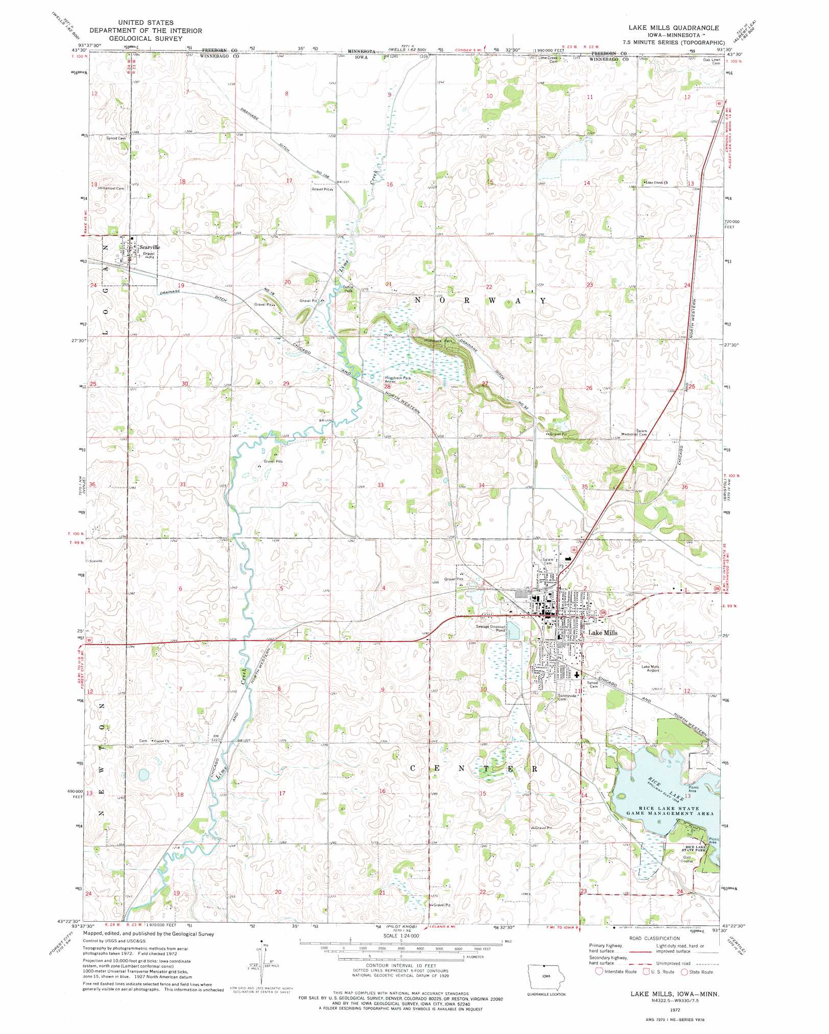
USGS Topo Quad 43093d5 - 1:24,000 scale
| Topo Map Name: | Lake Mills |
| USGS Topo Quad ID: | 43093d5 |
| Print Size: | ca. 21 1/4" wide x 27" high |
| Southeast Coordinates: | 43.375° N latitude / 93.5° W longitude |
| Map Center Coordinates: | 43.4375° N latitude / 93.5625° W longitude |
| U.S. States: | IA, MN |
| Filename: | o43093d5.jpg |
| Download Map JPG Image: | Lake Mills topo map 1:24,000 scale |
| Map Type: | Topographic |
| Topo Series: | 7.5´ |
| Map Scale: | 1:24,000 |
| Source of Map Images: | United States Geological Survey (USGS) |
| Alternate Map Versions: |
Lake Mills IA 1972, updated 1975 Download PDF Buy paper map Lake Mills IA 2010 Download PDF Buy paper map Lake Mills IA 2013 Download PDF Buy paper map Lake Mills IA 2015 Download PDF Buy paper map |
1:24,000 Topo Quads surrounding Lake Mills
Brush Creek |
Wells |
Alden |
Albert Lea West |
Albert Lea East |
Bricelyn |
Kiester |
Conger |
Emmons |
Glenville |
Buffalo Center Ne |
Vinje |
Lake Mills |
Bristol |
Fertile Ne |
Thompson |
Forest City |
Pilot Knob |
Fertile |
Fertile Se |
Crystal Lake |
Hayfield |
Miller |
Clear Lake West |
Clear Lake East |
> Back to 43093a1 at 1:100,000 scale
> Back to 43092a1 at 1:250,000 scale
> Back to U.S. Topo Maps home
Lake Mills topo map: Gazetteer
Lake Mills: Airports
Lake Mills Municipal Airport elevation 382m 1253′Lake Mills: Areas
Hogsback Marsh Public Hunting Area elevation 375m 1230′Lake Mills: Canals
Drainage Ditch Number 108 elevation 376m 1233′Drainage Ditch Number 18 elevation 378m 1240′
Drainage Ditch Number 92 elevation 379m 1243′
Lake Mills: Lakes
Greenley Lake (historical) elevation 380m 1246′Lake Mills: Parks
Bolstad Wildlife Area elevation 389m 1276′Dahle Park elevation 375m 1230′
Hogsback Park Annex elevation 375m 1230′
Hogsback Wildlife Area elevation 390m 1279′
Lande River Conservation Wildlife Area elevation 374m 1227′
Larson - Tweed Wildlife Area elevation 381m 1250′
Oakwood Park elevation 388m 1272′
Rice Lake State Park elevation 386m 1266′
Wood Duck Marsh elevation 381m 1250′
Lake Mills: Populated Places
Lake Mills elevation 393m 1289′Scarville elevation 382m 1253′
Lake Mills: Post Offices
Lake Mills Post Office elevation 391m 1282′Scarville Post Office elevation 382m 1253′
Lake Mills: Reservoirs
Rice Lake elevation 380m 1246′Lake Mills digital topo map on disk
Buy this Lake Mills topo map showing relief, roads, GPS coordinates and other geographical features, as a high-resolution digital map file on DVD: