Wallingford Topo Map Iowa
To zoom in, hover over the map of Wallingford
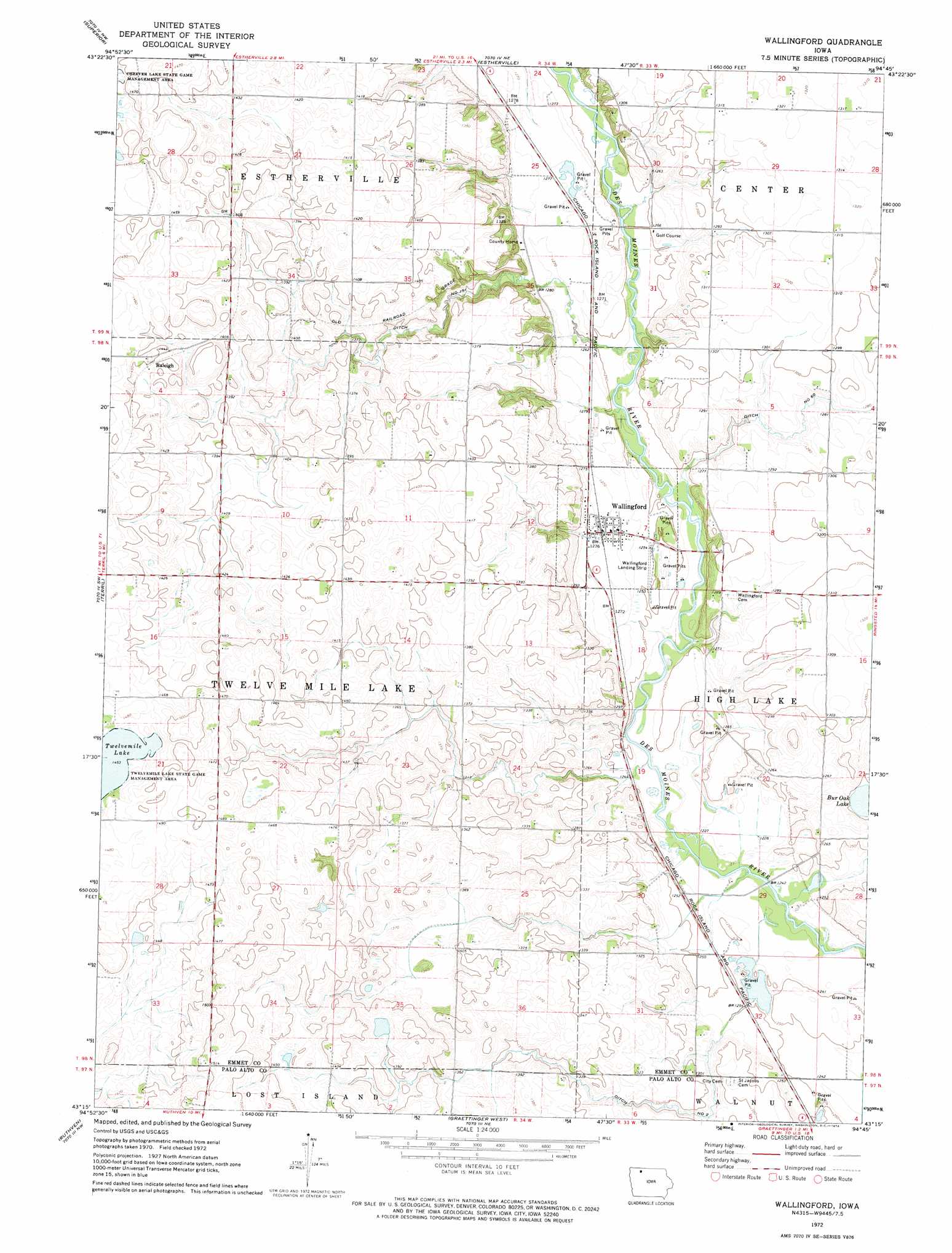
USGS Topo Quad 43094c7 - 1:24,000 scale
| Topo Map Name: | Wallingford |
| USGS Topo Quad ID: | 43094c7 |
| Print Size: | ca. 21 1/4" wide x 27" high |
| Southeast Coordinates: | 43.25° N latitude / 94.75° W longitude |
| Map Center Coordinates: | 43.3125° N latitude / 94.8125° W longitude |
| U.S. State: | IA |
| Filename: | o43094c7.jpg |
| Download Map JPG Image: | Wallingford topo map 1:24,000 scale |
| Map Type: | Topographic |
| Topo Series: | 7.5´ |
| Map Scale: | 1:24,000 |
| Source of Map Images: | United States Geological Survey (USGS) |
| Alternate Map Versions: |
Wallingford IA 1972, updated 1974 Download PDF Buy paper map Wallingford IA 2010 Download PDF Buy paper map Wallingford IA 2013 Download PDF Buy paper map Wallingford IA 2015 Download PDF Buy paper map |
1:24,000 Topo Quads surrounding Wallingford
Lakefield Se |
Jackson |
Dunnell |
Ceylon |
Wilbert |
Spirit Lake |
Superior |
Estherville |
Gruver |
Dolliver |
Spirit Lake Se |
Terril |
Wallingford |
Ingham Lake |
Ringsted |
Dickens |
Ruthven |
Graettinger West |
Graettinger East |
Depew |
Gillett Grove |
Silver Lake |
Ayrshire |
Emmetsburg |
Cylinder |
> Back to 43094a1 at 1:100,000 scale
> Back to 43094a1 at 1:250,000 scale
> Back to U.S. Topo Maps home
Wallingford topo map: Gazetteer
Wallingford: Airports
Wallingford Landing Strip elevation 381m 1250′Wallingford: Canals
Ditch Number 151 elevation 397m 1302′Ditch Number 2 elevation 393m 1289′
Ditch Number 60 elevation 386m 1266′
Wallingford: Lakes
Bur Oak Lake elevation 380m 1246′Wallingford: Parks
Burr Oak Lake Wildlife Management Area elevation 380m 1246′Twelvemile Lake State Game Management Area elevation 443m 1453′
Wallingford: Populated Places
Raleigh elevation 445m 1459′Wallingford elevation 388m 1272′
Wallingford: Post Offices
High Lake Post Office (historical) elevation 385m 1263′Highlake Post Office (historical) elevation 392m 1286′
New Bergen Post Office (historical) elevation 386m 1266′
Raleigh Post Office (historical) elevation 445m 1459′
Twelve Mile Lake Post Office (historical) elevation 444m 1456′
Wallingford Post Office elevation 388m 1272′
Wallingford digital topo map on disk
Buy this Wallingford topo map showing relief, roads, GPS coordinates and other geographical features, as a high-resolution digital map file on DVD: