Wilmert Lake Topo Map Minnesota
To zoom in, hover over the map of Wilmert Lake
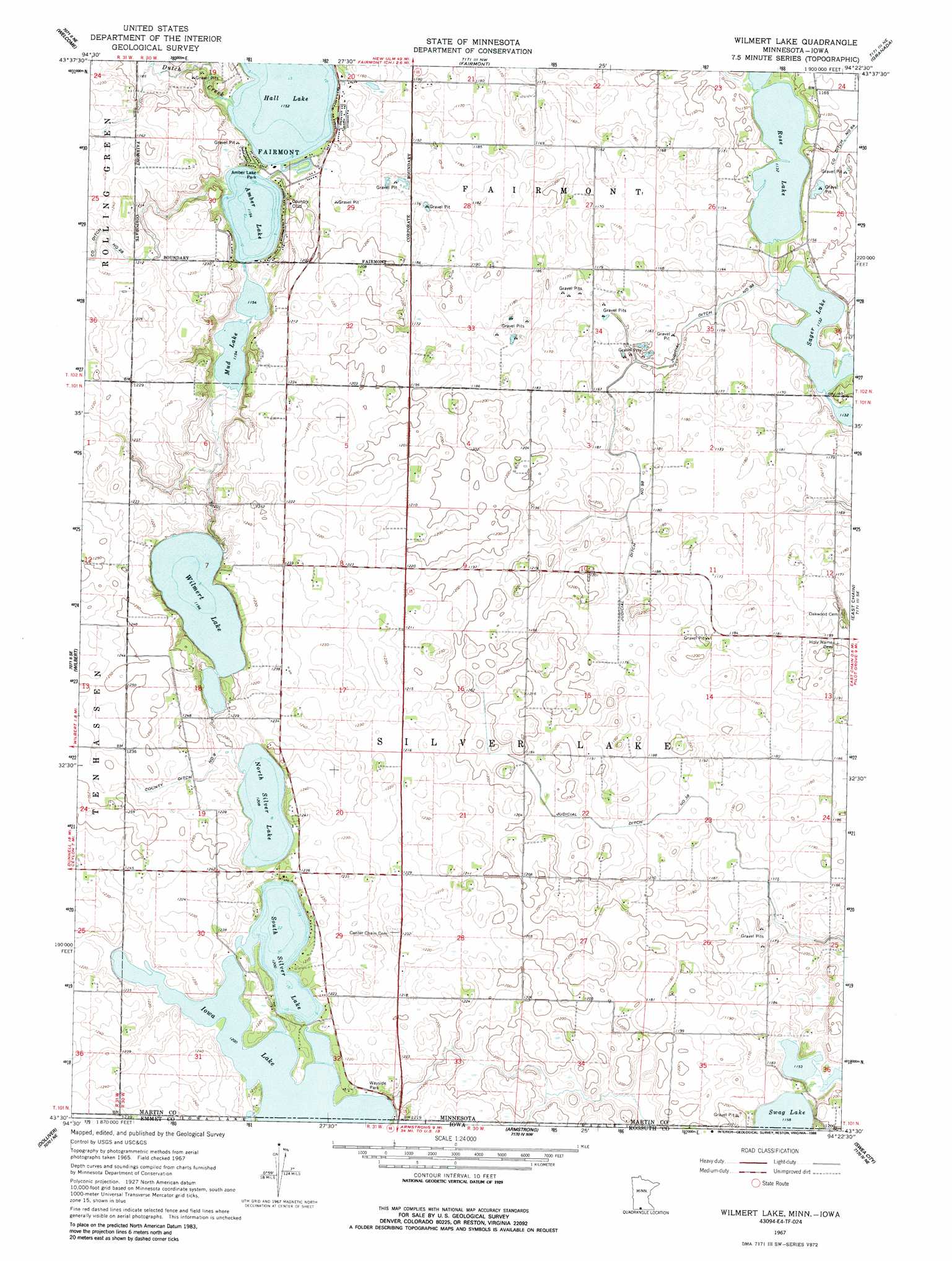
USGS Topo Quad 43094e4 - 1:24,000 scale
| Topo Map Name: | Wilmert Lake |
| USGS Topo Quad ID: | 43094e4 |
| Print Size: | ca. 21 1/4" wide x 27" high |
| Southeast Coordinates: | 43.5° N latitude / 94.375° W longitude |
| Map Center Coordinates: | 43.5625° N latitude / 94.4375° W longitude |
| U.S. States: | MN, IA |
| Filename: | o43094e4.jpg |
| Download Map JPG Image: | Wilmert Lake topo map 1:24,000 scale |
| Map Type: | Topographic |
| Topo Series: | 7.5´ |
| Map Scale: | 1:24,000 |
| Source of Map Images: | United States Geological Survey (USGS) |
| Alternate Map Versions: |
Wilmert Lake MN 1967, updated 1968 Download PDF Buy paper map Wilmert Lake MN 1967, updated 1988 Download PDF Buy paper map Willmert Lake MN 2010 Download PDF Buy paper map Willmert Lake MN 2013 Download PDF Buy paper map Willmert Lake MN 2016 Download PDF Buy paper map |
1:24,000 Topo Quads surrounding Wilmert Lake
Trimont |
Saint James Se |
Truman |
Truman Se |
Winnebago |
Sherburn |
Welcome |
Fairmont |
Granada |
Huntley |
Ceylon |
Wilbert |
Wilmert Lake |
East Chain |
Pilot Grove |
Gruver |
Dolliver |
Armstrong |
Swea City |
Ledyard |
Ingham Lake |
Ringsted |
Seneca |
Armstrong Se |
Bancroft |
> Back to 43094e1 at 1:100,000 scale
> Back to 43094a1 at 1:250,000 scale
> Back to U.S. Topo Maps home
Wilmert Lake topo map: Gazetteer
Wilmert Lake: Canals
County Ditch Number Nine elevation 372m 1220′Judicial Ditch Number Ninetyeight elevation 354m 1161′
Judicial Ditch Number Thirtyeight elevation 357m 1171′
Wilmert Lake: Dams
North Silver Lake Dam elevation 366m 1200′Wilmert Lake: Lakes
Amber Lake elevation 351m 1151′Hall Lake elevation 351m 1151′
Iowa Lake elevation 366m 1200′
Mud Lake elevation 351m 1151′
North Silver Lake elevation 366m 1200′
Rose Lake elevation 345m 1131′
Sager Lake elevation 345m 1131′
South Silver Lake elevation 366m 1200′
Swag Lake elevation 351m 1151′
Willmert Lake elevation 363m 1190′
Wilmert Lake: Parks
Amber Lake Park elevation 353m 1158′Cedar Park elevation 359m 1177′
Wilmert Lake: Reservoirs
North Silver Lake elevation 366m 1200′Wilmert Lake: Streams
Dutch Creek elevation 352m 1154′Wilmert Lake digital topo map on disk
Buy this Wilmert Lake topo map showing relief, roads, GPS coordinates and other geographical features, as a high-resolution digital map file on DVD: