Blue Earth Topo Map Minnesota
To zoom in, hover over the map of Blue Earth
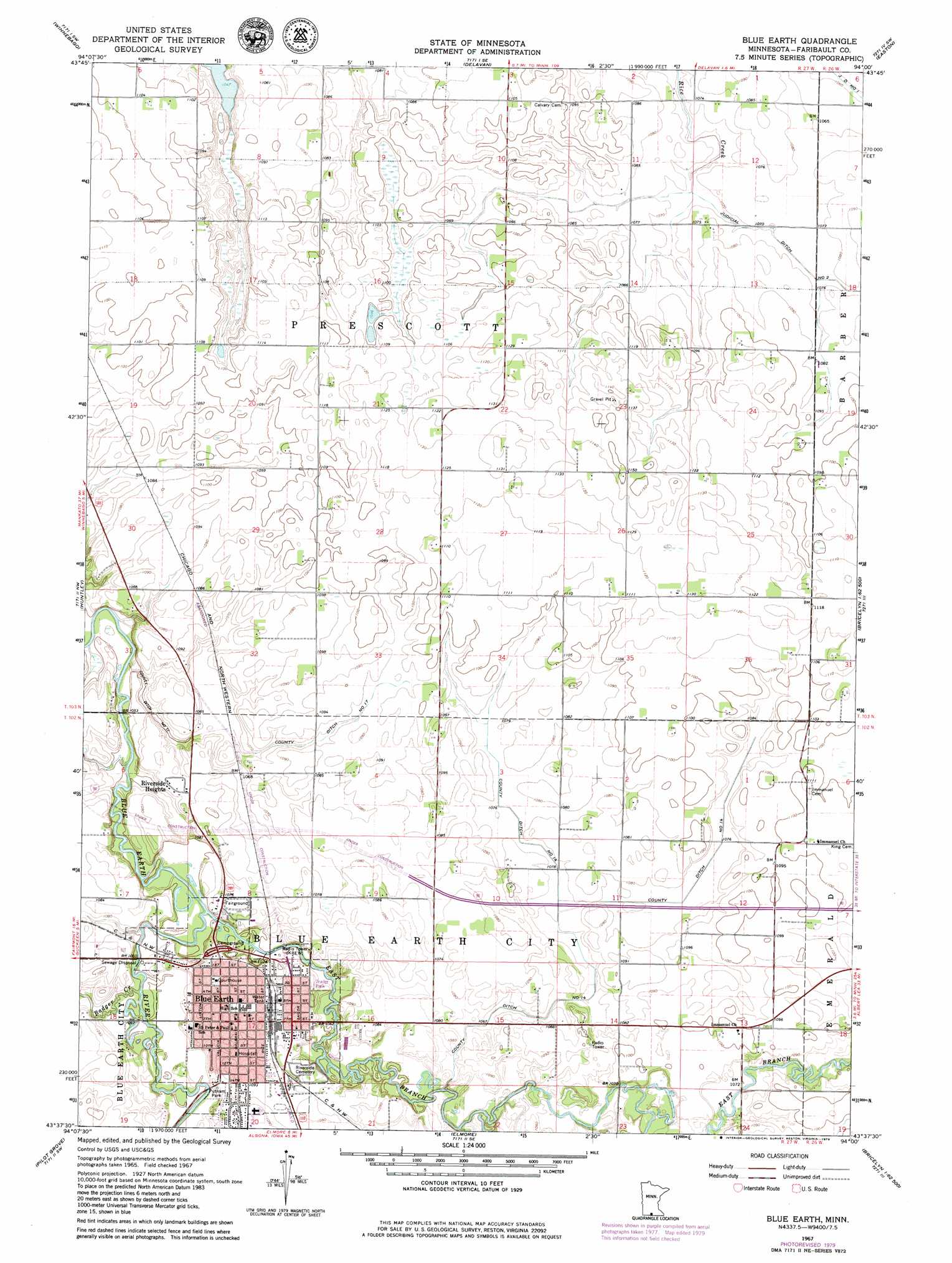
USGS Topo Quad 43094f1 - 1:24,000 scale
| Topo Map Name: | Blue Earth |
| USGS Topo Quad ID: | 43094f1 |
| Print Size: | ca. 21 1/4" wide x 27" high |
| Southeast Coordinates: | 43.625° N latitude / 94° W longitude |
| Map Center Coordinates: | 43.6875° N latitude / 94.0625° W longitude |
| U.S. State: | MN |
| Filename: | o43094f1.jpg |
| Download Map JPG Image: | Blue Earth topo map 1:24,000 scale |
| Map Type: | Topographic |
| Topo Series: | 7.5´ |
| Map Scale: | 1:24,000 |
| Source of Map Images: | United States Geological Survey (USGS) |
| Alternate Map Versions: |
Blue Earth MN 1967, updated 1970 Download PDF Buy paper map Blue Earth MN 1967, updated 1979 Download PDF Buy paper map Blue Earth MN 2010 Download PDF Buy paper map Blue Earth MN 2013 Download PDF Buy paper map Blue Earth MN 2016 Download PDF Buy paper map |
1:24,000 Topo Quads surrounding Blue Earth
Willow Creek |
Amboy |
Sterling Center |
Mapleton |
Mapleton Ne |
Truman Se |
Winnebago |
Delavan |
Easton |
Minnesota Lake |
Granada |
Huntley |
Blue Earth |
Oza Tanka Lakebed |
Brush Creek |
East Chain |
Pilot Grove |
Elmore |
Frost |
Bricelyn |
Swea City |
Ledyard |
Lakota |
Buffalo Center |
Buffalo Center Ne |
> Back to 43094e1 at 1:100,000 scale
> Back to 43094a1 at 1:250,000 scale
> Back to U.S. Topo Maps home
Blue Earth topo map: Gazetteer
Blue Earth: Airports
Fenske Airport elevation 339m 1112′Blue Earth: Canals
County Ditch Number Fourteen elevation 326m 1069′County Ditch Number Seventeen elevation 326m 1069′
Judicial Ditch Number Two elevation 327m 1072′
Blue Earth: Crossings
Interchange 119 elevation 326m 1069′Blue Earth: Parks
Beyer Field elevation 320m 1049′Exploring Southwestern Minnesota Historical Marker elevation 331m 1085′
Green Giant Statue Park elevation 330m 1082′
Leland Park elevation 320m 1049′
Minnesota Agriculture Historical Marker elevation 328m 1076′
Putnam Park elevation 325m 1066′
Blue Earth: Populated Places
Blue Earth elevation 332m 1089′Hillcrest Park Mobile Home Park elevation 322m 1056′
Riverside Heights elevation 330m 1082′
Blue Earth: Post Offices
Blue Earth Post Office elevation 330m 1082′Blue Earth: Streams
Badger Creek elevation 320m 1049′East Branch Blue Earth River elevation 318m 1043′
Blue Earth: Trails
Drexler Bicentennial Trail elevation 321m 1053′Unity Trail elevation 318m 1043′
Blue Earth digital topo map on disk
Buy this Blue Earth topo map showing relief, roads, GPS coordinates and other geographical features, as a high-resolution digital map file on DVD: