Trimont Topo Map Minnesota
To zoom in, hover over the map of Trimont
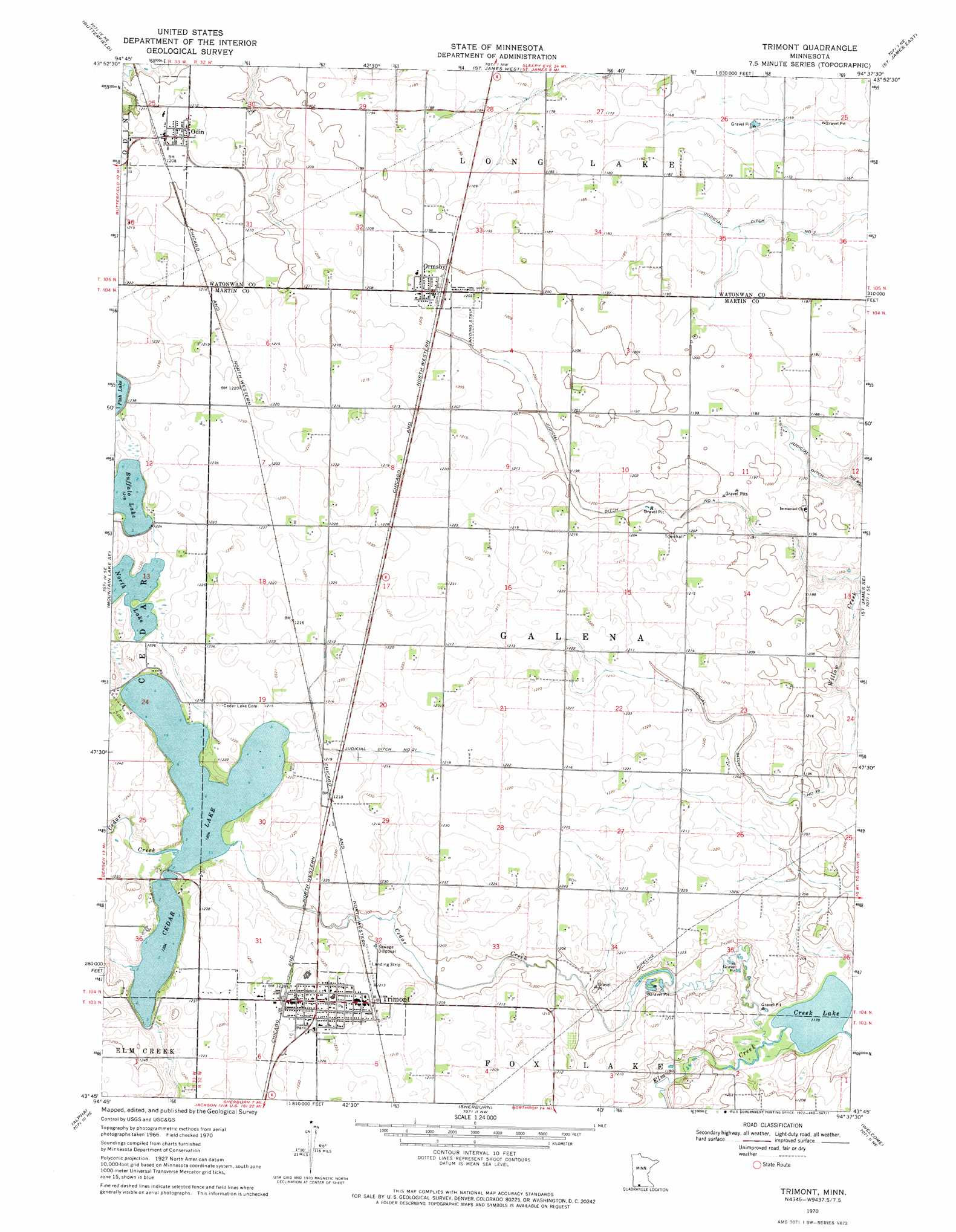
USGS Topo Quad 43094g6 - 1:24,000 scale
| Topo Map Name: | Trimont |
| USGS Topo Quad ID: | 43094g6 |
| Print Size: | ca. 21 1/4" wide x 27" high |
| Southeast Coordinates: | 43.75° N latitude / 94.625° W longitude |
| Map Center Coordinates: | 43.8125° N latitude / 94.6875° W longitude |
| U.S. State: | MN |
| Filename: | o43094g6.jpg |
| Download Map JPG Image: | Trimont topo map 1:24,000 scale |
| Map Type: | Topographic |
| Topo Series: | 7.5´ |
| Map Scale: | 1:24,000 |
| Source of Map Images: | United States Geological Survey (USGS) |
| Alternate Map Versions: |
Trimont MN 1970, updated 1972 Download PDF Buy paper map Trimont MN 2010 Download PDF Buy paper map Trimont MN 2013 Download PDF Buy paper map Trimont MN 2016 Download PDF Buy paper map |
1:24,000 Topo Quads surrounding Trimont
Comfrey |
Darfur |
Godahl |
La Salle |
Madelia |
Mountain Lake |
Butterfield |
Saint James West |
Saint James East |
Lewisville |
Bergen |
Mountain Lake Se |
Trimont |
Saint James Se |
Truman |
Jackson Nw |
Alpha |
Sherburn |
Welcome |
Fairmont |
Jackson |
Dunnell |
Ceylon |
Wilbert |
Wilmert Lake |
> Back to 43094e1 at 1:100,000 scale
> Back to 43094a1 at 1:250,000 scale
> Back to U.S. Topo Maps home
Trimont topo map: Gazetteer
Trimont: Canals
Judicial Ditch Number Eightytwo elevation 357m 1171′Judicial Ditch Number Four elevation 363m 1190′
Judicial Ditch Number Thirtynine elevation 366m 1200′
Judicial Ditch Number Twentyone elevation 369m 1210′
Judicial Ditch Number Two elevation 354m 1161′
Trimont: Lakes
Buffalo Lake elevation 371m 1217′Cedar Lake elevation 367m 1204′
Creek Lake elevation 357m 1171′
North Lake elevation 371m 1217′
Trimont: Populated Places
Odin elevation 369m 1210′Ormsby elevation 367m 1204′
Trimont elevation 372m 1220′
Trimont: Post Offices
Odin Post Office elevation 369m 1210′Ormsby Post Office elevation 367m 1204′
Trimont Post Office elevation 377m 1236′
Triumph Post Office (historical) elevation 372m 1220′
Trimont: Streams
Cedar Creek elevation 358m 1174′Trimont digital topo map on disk
Buy this Trimont topo map showing relief, roads, GPS coordinates and other geographical features, as a high-resolution digital map file on DVD: