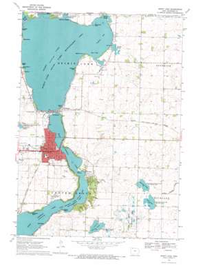
Spirit Lake Topo Map Iowa
To zoom in, hover over the map of Spirit Lake
USGS Topo Quad 43095d1 - 1:24,000 scale
| Topo Map Name: | Spirit Lake |
| USGS Topo Quad ID: | 43095d1 |
| Print Size: | ca. 21 1/4" wide x 27" high |
| Southeast Coordinates: | 43.375° N latitude / 95° W longitude |
| Map Center Coordinates: | 43.4375° N latitude / 95.0625° W longitude |
| U.S. State: | IA |
| Filename: | o43095d1.jpg |
| Download Map JPG Image: | Spirit Lake topo map 1:24,000 scale |
| Map Type: | Topographic |
| Topo Series: | 7.5´ |
| Map Scale: | 1:24,000 |
| Source of Map Images: | United States Geological Survey (USGS) |
| Alternate Map Versions: |
Spirit Lake IA 1970, updated 1972 Download PDF Buy paper map Spirit Lake IA 2010 Download PDF Buy paper map Spirit Lake IA 2013 Download PDF Buy paper map Spirit Lake IA 2015 Download PDF Buy paper map |
1:24,000 Topo Quads surrounding Spirit Lake
> Back to 43095a1 at 1:100,000 scale
> Back to 43094a1 at 1:250,000 scale
> Back to U.S. Topo Maps home
Spirit Lake topo map: Gazetteer
Spirit Lake: Airports
Dickinson County Memorial Hospital Heliport elevation 444m 1456′Spirit Lake: Bays
Anglers Bay elevation 427m 1400′Anglers Bay elevation 427m 1400′
East Bay elevation 427m 1400′
Stevens Cove elevation 427m 1400′
Templar Harbor elevation 427m 1400′
Spirit Lake: Beaches
Ainsworth Beach elevation 427m 1400′Anglers Bay Beach elevation 428m 1404′
Brooks Beach elevation 426m 1397′
Cedar Rapids Beach elevation 430m 1410′
Chalstroms Beach elevation 426m 1397′
Crandalls Beach elevation 428m 1404′
East Okoboji Beach elevation 426m 1397′
Harlan Beach elevation 428m 1404′
Inwood Park Beach elevation 427m 1400′
Kellys Beach elevation 428m 1404′
Maple Oak Beach elevation 431m 1414′
Marble Beach elevation 428m 1404′
Martha Yarns Memorial Beach elevation 431m 1414′
McClelland Beach elevation 427m 1400′
Miniwaukon Beach elevation 428m 1404′
Moores Beach elevation 426m 1397′
Orleans Beach elevation 431m 1414′
Pioneer Beach elevation 432m 1417′
Sandbar Beach elevation 428m 1404′
Twin Hills Beach elevation 429m 1407′
Spirit Lake: Capes
Bakers Point elevation 427m 1400′Big Stony Point elevation 429m 1407′
Cottonwood Point elevation 427m 1400′
Kulp Point elevation 428m 1404′
Little Stoney Point elevation 430m 1410′
Lone Tree Point elevation 426m 1397′
Peppermint Point elevation 427m 1400′
Red Nose Point elevation 431m 1414′
Stoney Point elevation 426m 1397′
Templar Point elevation 427m 1400′
The Narrows Point elevation 426m 1397′
Spirit Lake: Guts
Hale Slough elevation 427m 1400′Jemmerson Slough elevation 434m 1423′
McClelland Slough elevation 427m 1400′
Sandbar Slough elevation 427m 1400′
Trickle Slough elevation 428m 1404′
Spirit Lake: Lakes
East Okoboji Lake elevation 426m 1397′Lily Lake elevation 463m 1519′
Pleasant Lake elevation 463m 1519′
Prairie Lake elevation 452m 1482′
Spirit Lake elevation 427m 1400′
Spirit Lake: Parks
First White Girl Born in Dickinson County Historical Marker elevation 450m 1476′Gilbert Park elevation 427m 1400′
Hales Slough Area elevation 428m 1404′
Howe Cabin Historical Marker elevation 452m 1482′
J Jahn Park elevation 449m 1473′
Little League Park elevation 448m 1469′
Marble Beach State Recreation Area elevation 427m 1400′
Memorial Park elevation 431m 1414′
Mini Wakan State Park elevation 428m 1404′
Noble Cabin Historical Marker elevation 446m 1463′
Orleans State Park elevation 430m 1410′
Pleasant Lake State Game Management Area elevation 463m 1519′
Spirit Lake State Game Management Area elevation 427m 1400′
Spring Run State Game Management Areas elevation 457m 1499′
Stockade Protection from Indians Historical Marker elevation 451m 1479′
Templer Park elevation 428m 1404′
Trickle Slough Area elevation 427m 1400′
Spirit Lake: Populated Places
Orleans elevation 429m 1407′Sand Bar Beach Resort and Trailer Court elevation 428m 1404′
Spirit Lake elevation 449m 1473′
Spirit Lake: Post Offices
Hunters Post Office (historical) elevation 429m 1407′Orleans Post Office (historical) elevation 429m 1407′
Spirit Lake Post Office elevation 443m 1453′
Spirit Lake: Streams
Loon Creek elevation 427m 1400′Loon Creek elevation 427m 1400′
Spirit Lake digital topo map on disk
Buy this Spirit Lake topo map showing relief, roads, GPS coordinates and other geographical features, as a high-resolution digital map file on DVD:


