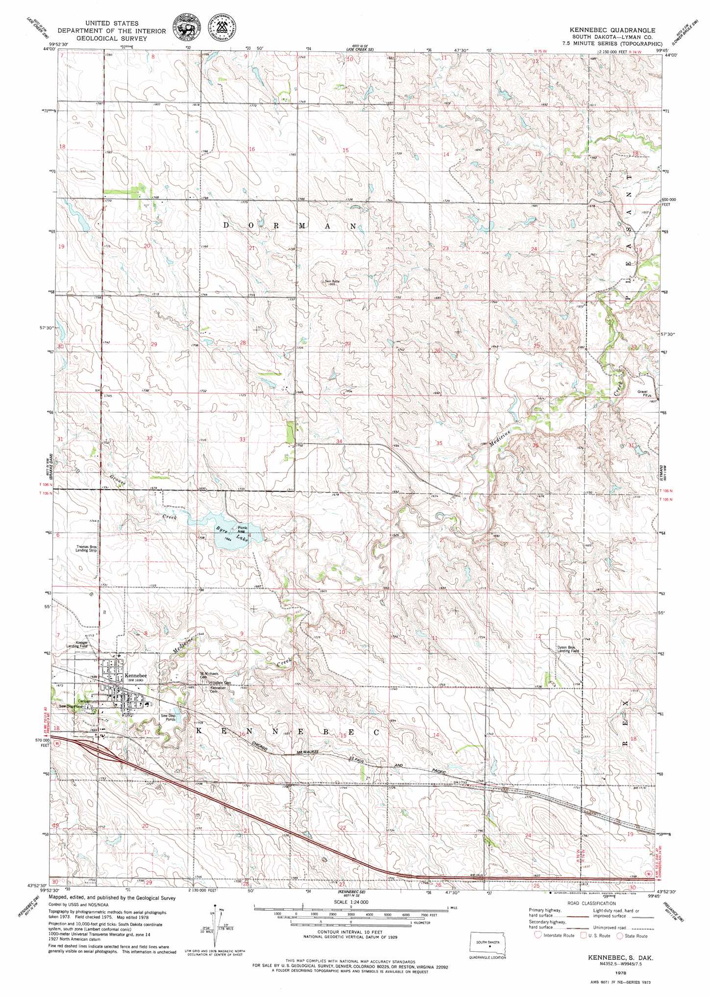
Kennebec Topo Map South Dakota
To zoom in, hover over the map of Kennebec
USGS Topo Quad 43099h7 - 1:24,000 scale
| Topo Map Name: | Kennebec |
| USGS Topo Quad ID: | 43099h7 |
| Print Size: | ca. 21 1/4" wide x 27" high |
| Southeast Coordinates: | 43.875° N latitude / 99.75° W longitude |
| Map Center Coordinates: | 43.9375° N latitude / 99.8125° W longitude |
| U.S. State: | SD |
| Filename: | o43099h7.jpg |
| Download Map JPG Image: | Kennebec topo map 1:24,000 scale |
| Map Type: | Topographic |
| Topo Series: | 7.5´ |
| Map Scale: | 1:24,000 |
| Source of Map Images: | United States Geological Survey (USGS) |
| Alternate Map Versions: |
Kennebec SD 1978, updated 1979 Download PDF Buy paper map Kennebec SD 2012 Download PDF Buy paper map Kennebec SD 2015 Download PDF Buy paper map |
1:24,000 Topo Quads surrounding Kennebec
Fort George Butte |
Joe Creek Nw |
Joe Creek |
Lower Brule Nw |
Lower Brule Ne |
Fort George Butte Se |
Joe Creek Sw |
Joe Creek Se |
Lower Brule Sw |
Lower Brule |
Presho |
Brakke Dam |
Kennebec |
Lyman |
Reliance |
Presho Se |
Kennebec Sw |
Kennebec Se |
Reliance Sw |
Reliance Se |
Presho 4 Ne |
Ideal Nw |
Ideal Ne |
Hamill Nw |
Hamill Ne |
> Back to 43099e1 at 1:100,000 scale
> Back to 43098a1 at 1:250,000 scale
> Back to U.S. Topo Maps home
Kennebec topo map: Gazetteer
Kennebec: Airports
Anderson Private Airstrip elevation 512m 1679′Dyson Brothers Landing Field elevation 537m 1761′
Kreager Landing Field elevation 522m 1712′
Thomas Brothers Landing Strip elevation 524m 1719′
Kennebec: Dams
Byre Dam elevation 513m 1683′Dorman Dam elevation 528m 1732′
Kennebec: Populated Places
Kennebec elevation 513m 1683′Kennebec: Reservoirs
Byre Lake elevation 513m 1683′Kennebec: Streams
Grouse Creek elevation 500m 1640′Kennebec digital topo map on disk
Buy this Kennebec topo map showing relief, roads, GPS coordinates and other geographical features, as a high-resolution digital map file on DVD:
Eastern North Dakota & Eastern South Dakota
Buy digital topo maps: Eastern North Dakota & Eastern South Dakota