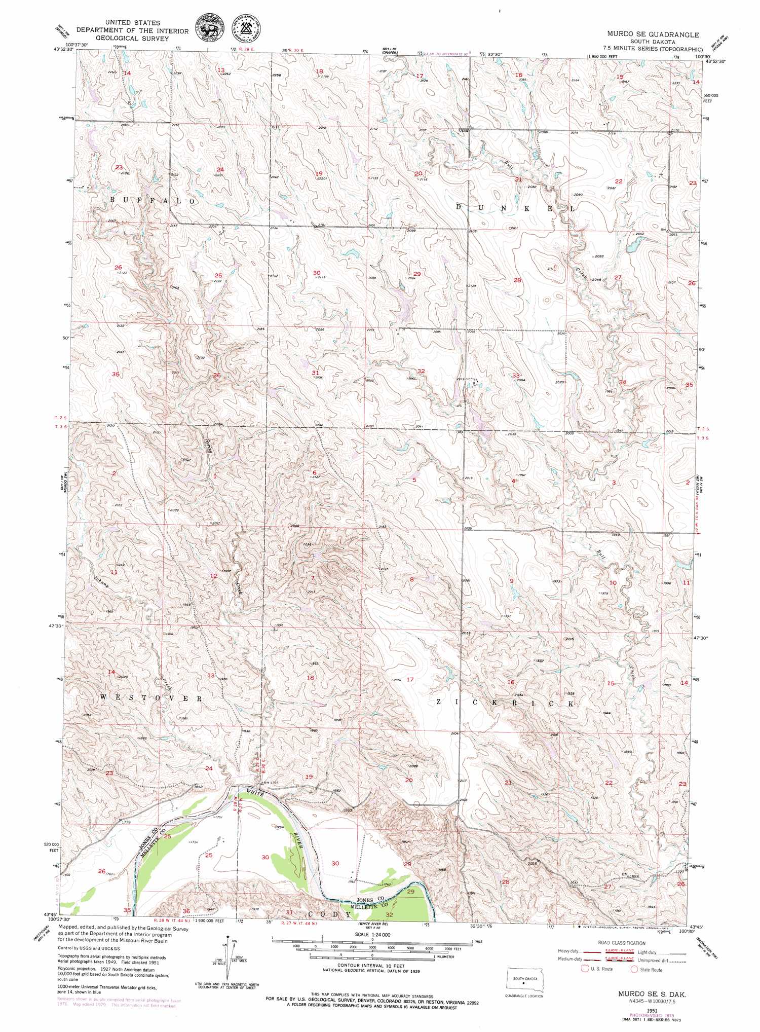
Murdo Se Topo Map South Dakota
To zoom in, hover over the map of Murdo Se
USGS Topo Quad 43100g5 - 1:24,000 scale
| Topo Map Name: | Murdo Se |
| USGS Topo Quad ID: | 43100g5 |
| Print Size: | ca. 21 1/4" wide x 27" high |
| Southeast Coordinates: | 43.75° N latitude / 100.5° W longitude |
| Map Center Coordinates: | 43.8125° N latitude / 100.5625° W longitude |
| U.S. State: | SD |
| Filename: | o43100g5.jpg |
| Download Map JPG Image: | Murdo Se topo map 1:24,000 scale |
| Map Type: | Topographic |
| Topo Series: | 7.5´ |
| Map Scale: | 1:24,000 |
| Source of Map Images: | United States Geological Survey (USGS) |
| Alternate Map Versions: |
Murdo SE SD 1951, updated 1953 Download PDF Buy paper map Murdo SE SD 2012 Download PDF Buy paper map Murdo SE SD 2015 Download PDF Buy paper map |
1:24,000 Topo Quads surrounding Murdo Se
Capa Se |
Wendte Sw |
Wendte Se |
Pierre 3 Sw |
Pierre 3 Se |
Okaton Ne |
Murdo |
Draper |
Vivian Nw |
Vivian |
Okaton Se |
Murdo Sw |
Murdo Se |
Vivian Sw |
Vivian Se |
Murdo 3 Ne |
Westover |
White River Ne |
Badnation Nw |
Badnation |
White River West |
White River East |
White River Se |
Wood North |
Badnation Se |
> Back to 43100e1 at 1:100,000 scale
> Back to 43100a1 at 1:250,000 scale
> Back to U.S. Topo Maps home
Murdo Se topo map: Gazetteer
Murdo Se: Dams
Brost Number 3 Dam elevation 598m 1961′Brost Number 4 Dam elevation 565m 1853′
Brost Number 5 Dam elevation 601m 1971′
Brost Number 6 Dam elevation 646m 2119′
Brost Number 7 Dam elevation 647m 2122′
Brost Number 8 Dam elevation 654m 2145′
Dalhke Ranch Number 1 Dam elevation 594m 1948′
Dalhke Ranch Number 2 Dam elevation 619m 2030′
Dalhke Ranch Number 3 Dam elevation 604m 1981′
Dalhke Ranch Number 4 Dam elevation 592m 1942′
Dalhke Ranch Number 5 Dam elevation 611m 2004′
Dalhke Ranch Number 6 Dam elevation 617m 2024′
Rankin Number 1 Dam elevation 592m 1942′
Rankin Number 2 Dam elevation 590m 1935′
Murdo Se: Streams
Johnny Creek elevation 531m 1742′Spring Creek elevation 531m 1742′
Murdo Se digital topo map on disk
Buy this Murdo Se topo map showing relief, roads, GPS coordinates and other geographical features, as a high-resolution digital map file on DVD:
Eastern North Dakota & Eastern South Dakota
Buy digital topo maps: Eastern North Dakota & Eastern South Dakota